

You are here
Avalanche Forecast for 2019-03-27 05:05
- EXPIRED ON March 28, 2019 @ 5:05 amPublished on March 27, 2019 @ 5:05 am
- Issued by Nick Meyers - Shasta-Trinity National Forest
Bottom Line
Another late winter storm is on tap. The avalanche danger will spike today during periods of heavy snowfall and strong, southerly wind. Fresh wind slabs are likely to form and could be sensitive to trigger. Leeward NW-N-NE-E aspects will be most suspect. Play it safe during the storm.


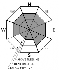
Avalanche Problem 1: Wind Slab
-
Character ?

-
Aspect/Elevation ?
-
Likelihood ?CertainVery LikelyLikelyPossible
 Unlikely
 -
Size ?HistoricVery LargeLargeSmall

The primary concern for today will be fresh wind slabs from our current storm. While existing storm snow from two days ago has settled and bonded well to the old snow surfaces, old wind slabs may also become reactive with additional snow load. Larger avalanches could be possible. Wind is out of the south and new snow totals are forecast in the 12+ inches range for the next 24 hours. Instabilities almost always occur during, or just after heavy snow and/or wind. If visibility allows, play it safe near and above treeline.
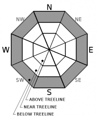
Avalanche Problem 2: Storm Slab
-
Character ?

-
Aspect/Elevation ?
-
Likelihood ?CertainVery LikelyLikelyPossible
Unlikely
-
Size ?HistoricVery LargeLargeSmall
In steep, protected areas below treeline where more than 6 inches of new snowfall has accumulated, watch for signs of a storm slab hazard. Storm slabs are a release of a soft cohesive layer (a slab) of new snow that breaks within the storm snow or on the old snow surface. For us around here, storm-slab problems typically last a few hours. Ski cut results on small inconsequential slopes, or natural activity on indicator slopes are often the best clues that a storm slab problem exists.
Forecast Discussion
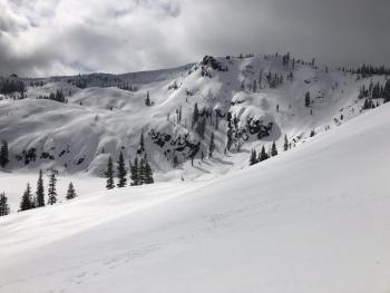
By the book, it's Spring... but snow is still falling from the sky here in Mount Shasta. Remember, anytime that sun comes out after fresh snow, loose-wet avalanche instability should be on your radar. The sun impacts on the snow are much greater this time of year. While stability tests may not show us anything askew, mother nature gives us plenty of warning signs. Temps above freezing, sun, rollerballs, point releases and sloppy, mushy or slushy snow are great examples. If you see these signs, it's time to get out of harms way. For today, fresh snow and wind will keep loose-wet's at bay.
Recent Observations
Yesterday, high temperatures from local weather stations were all over the board, ranging from 29 to 41 degrees F. Up to 11 inches of new snow was measured up in the Castle Lake area. Several inches of settlement was recorded by local snow depth sensors. Soft surface textures became sticky and moist. Rollerballs were observed even on northerly aspects. Cornice features were reactive to ski cuts within the new snow. Previous wind drifting was encountered in exposed areas, up to 1 foot deep, but very little active wind loading due to the moist nature of snow. No recent avalanches were observed. No observations came in from the big mountain.

Weather and Current Conditions
Weather Summary
Low pressure centered off the Northern California coast will spin numerous waves of wet weather our way over the next 48 hours. A winter storm warning is in effect until 11pm PDT this evening above 4,000 feet. Strong winds are expected above treeline. The strongest winds will be today, but breezy conditions will last through tomorrow. Upwards of 1.6 inches of water is forecast through Thursday evening. We could see over a foot of new snow accumulate in the mountains. Snow levels should linger at 4,500 feet today, and with cooling temps, drop to near 3,000 feet tomorrow. Lower snow levels may be achieved during periods of heavy snowfall. High pressure will bring a break in the precipitation Saturday and Sunday, before the next round of weather knocks at the door.
24 Hour Weather Station Data @ 3:00 AM
| Weather Station | Temp (°F) | Wind (mi/hr) | Snow (in) | Comments | ||||||||
|---|---|---|---|---|---|---|---|---|---|---|---|---|
| Cur | Min | Max | Avg | Avg | Max Gust | Dir | Depth | New | Water Equivalent | Settlement | ||
| Mt. Shasta City (3540 ft) | 38 | 26 | 50 | 40 | 1 | N | ||||||
| Sand Flat (6750 ft) | 29 | 14 | 33 | 28 | 141 | 2 | n/a | 3 | ||||
| Ski Bowl (7600 ft) | 26.5 | 17 | 35 | 25 | 176 | 2 | 0.29 | 3 | ||||
| Gray Butte (8000 ft) | 25.5 | 16.5 | 29 | 24 | 8 | 25 | S | |||||
| Castle Lake (5870 ft) | 22.5 | 22.5 | 31.5 | 28.5 | 143 | 2 | 3 | |||||
| Mount Eddy (6509 ft) | 26.5 | 18 | 34 | 28 | 1 | 10 | SSW | 144 | 2 | 3 | ||
| Ash Creek Bowl (7250 ft) | ||||||||||||
| Ash Creek Ridge (7895 ft) |
Two Day Mountain Weather Forecast
Produced in partnership with the Medford NWS
| For 7000 ft to 9000 ft | |||
|---|---|---|---|
|
Wednesday (4 a.m. to 10 p.m.) |
Wednesday Night (10 p.m. to 4 a.m.) |
Thursday (4 a.m. to 10 p.m.) |
|
| Weather | Snow. Breezy Snow level near 4,500 feet. | Snow showers. Snow level near 4,100 feet | Snow. Breezy. Snow level near 3,600 feet. |
| Temperature (°F) | 30 | 26 | 32 |
| Wind (mi/hr) | South 10-15 | South 10-15 | South 10-15 |
| Precipitation SWE / Snowfall (in) | / 8-14 | / 4-8 | / 4-8 |
| For 9000 ft to 11000 ft | |||
| Wednesday | Wednesday Night | Thursday | |
| Weather | Snow, heavy at times. Windy. | Snow showers, windy. | Snow showers, breezy. |
| Temperature (°F) | 18 and falling | 9 | 12 |
| Wind (mi/hr) | South 40-50 | Southwest 10-16 | Southwest 25-35 |
| Precipitation SWE / Snowfall (in) | / 10-16 | / 6-8 | / 6-8 |
Season Precipitation for Mount Shasta City
| Period | Measured (in) | Normal (in) | Percent of Normal (%) |
|---|---|---|---|
| From Oct 1, 2025 (the wet season) | 33.53 | 34.79 | 96 |
| Month to Date (since Jun 1, 2026) | 4.00 | 5.29 | 76 |
| Year to Date (since Jan 1, 2026) | 25.12 | 19.58 | 128 |

