

You are here
Avalanche Forecast for 2019-12-08 06:45
- EXPIRED ON December 9, 2019 @ 6:45 amPublished on December 8, 2019 @ 6:45 am
- Issued by Ryan Sorenson - Mount Shasta Avalanche Center
Bottom Line
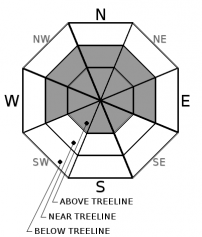
MODERATE avalanche danger today in near and above treeline terrain as nearly two feet of new snow from the last 48 hours continues to settle. Lingering windslabs could remain on steep leeward terrain. Natural avalanches are unlikely but human triggered avalanches are possible. Use caution and evaluate snow and terrain carefully. Identify areas of concern and adjust travel techniques accordingly. LOW danger exists below treeline.


Avalanche Problem 1: Wind Slab
-
Character ?

-
Aspect/Elevation ?
-
Likelihood ?CertainVery LikelyLikelyPossible
 Unlikely
 -
Size ?HistoricVery LargeLargeSmall

Wind has blown primarily from the southwest, loading northerly slopes and cross-loading westerly and easterly slopes. Winds are expected to switch to northerly today. Use caution and pay attention to where leeward areas reside. Stay away from steep slopes that have been loaded. Look for signs of the wind slab problem as you travel in safe terrain:
- Shooting cracks, blocking, whumphing
- Convex pillows of wind-drifted snow
- Chalky, hollow sounding snow
Forecast Discussion
Evaluate snow and terrain carefully. While the force required to trigger an avalanche will be difficult, avalanches are not impossible today.
Recent Observations
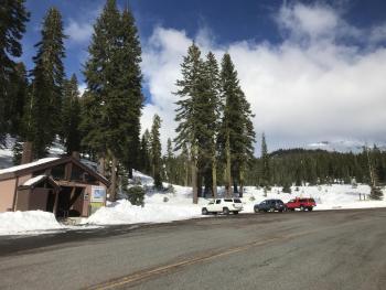
Precipitation was heavy at times on Mount Shasta yesterday morning. Bunny Flat at 0830 hours hosted poor visibility; constant moderate snowfall with periods of heavy snowfall near 2 inches per hour was observed. Snow levels fluctuated around the 5,900 to 6,200 foot mark. Old Ski Bowl weather station has recorded over two feet of new snow since this storm started late Friday night; 13 inches have been recorded in the last 24 hours mostly during day time hours. Temperatures in the last 24 hours have ranged from 28 F to 31 F.
A tour up Green Butte yesterday found snow surfaces to be supportable and smooth. Ski penetrations was 6 to 8 inches while boot penetration was 20 inches. Some evidence of wind effect in the form of small drifts and wind pillows were observed. Poor slab properties and overall stable conditions were observed. A pit dug on a west aspect at 8,300 feet measured 45 inches of snow to the ground. There was 26 inches of new snow atop an ice layer and supportable 1 finger hard snow. New snow showed a right side up configuration with 16 inches of light fist hard snow atop 10 inches of denser 4F hard snow below. Compression tests observed planar fractures at the density change 16 inches down (CTH down 45 cm Q1, ECTP22, ECTP22).
Weather and Current Conditions
Weather Summary
Expect clearing weather today as the recent storm pushes east out of the forecast area. There is a chance of some snow and rain showers in the morning with snow levels near 5,500 feet. The sun is expected to come out this afternoon as wind speeds drop off and shift out of the north throughout the day. Temperatures will top out near 35 degrees fahrenheit, and 5 to 10 mi/hr wind speeds are expected.
A small storm will move into the area on Tuesday bringing a chance of snow or rain. Snow levels could be as high as 8,000 feet. Expect continued unsettled and showery weather on Wednesday and Thursday.
24 Hour Weather Station Data @ 6:00 AM
| Weather Station | Temp (°F) | Wind (mi/hr) | Snow (in) | Comments | ||||||||
|---|---|---|---|---|---|---|---|---|---|---|---|---|
| Cur | Min | Max | Avg | Avg | Max Gust | Dir | Depth | New | Water Equivalent | Settlement | ||
| Mt. Shasta City (3540 ft) | 38 | 37.5 | 45 | 41 | 2 | N | ||||||
| Sand Flat (6750 ft) | 32 | 32 | 33 | 33 | 32 | 7 | 1.88 | 1 | ||||
| Ski Bowl (7600 ft) | 28.5 | 28 | 30.5 | 29 | 41.8 | 13.9 | 2.32 | 1.1 | ||||
| Gray Butte (8000 ft) | 27.5 | 26.5 | 30 | 28 | 15 | 37 | W | |||||
| Castle Lake (5870 ft) | 0 | 0 | 0 | 0 | 0 | 0 | 0 | not responding | ||||
| Mount Eddy (6509 ft) | 29.5 | 29.5 | 32.5 | 31.5 | 0 | 4 | ||||||
| Ash Creek Bowl (7250 ft) | down | |||||||||||
| Ash Creek Ridge (7895 ft) | down |
Two Day Mountain Weather Forecast
Produced in partnership with the Medford NWS
| For 7000 ft to 9000 ft | |||
|---|---|---|---|
|
Sunday (4 a.m. to 10 p.m.) |
Sunday Night (10 p.m. to 4 a.m.) |
Monday (4 a.m. to 10 p.m.) |
|
| Weather | Rain and snow showers clearing this afternoon. Snow levels near 5,500 feet. | Mostly clear | Partly cloudy in the morning then becoming sunny. |
| Temperature (°F) | 35 | 26 | 38 |
| Wind (mi/hr) | Northwest 0-5 | Northeast 5-10 | Northeast 0-5 |
| Precipitation SWE / Snowfall (in) | 0.03 / 0-1 | 0.00 / 0 | 0.00 / 0 |
| For 9000 ft to 11000 ft | |||
| Sunday | Sunday Night | Monday | |
| Weather | Partly cloudy and lingering snow showers becoming sunny. | Clear | Partly cloudy in the morning then becoming sunny. |
| Temperature (°F) | 27 | 27 | 35 |
| Wind (mi/hr) | Northwest 10-15 | North 10-15 | Northwest 10-15 |
| Precipitation SWE / Snowfall (in) | 0.03 / 0-1 | 0.00 / 0 | 0.00 / 0 |
Season Precipitation for Mount Shasta City
| Period | Measured (in) | Normal (in) | Percent of Normal (%) |
|---|---|---|---|
| From Oct 1, 2025 (the wet season) | 7.53 | 8.97 | 84 |
| Month to Date (since Jun 1, 2026) | 4.85 | 1.61 | 301 |
| Year to Date (since Jan 1, 2026) | 45.27 | 36.97 | 122 |

