

You are here
Avalanche Forecast for 2019-12-28 05:47
- EXPIRED ON December 29, 2019 @ 5:47 amPublished on December 28, 2019 @ 5:47 am
- Issued by Nick Meyers - Shasta-Trinity National Forest
Bottom Line
A savage, northwest wind event swept the forecast area yesterday. Wind slabs exist near and above treeline and human triggered avalanches are possible today. MODERATE danger continues near/above treeline and LOW danger below treeline in wind protected areas.
In the alpine, wind hammered terrain has been stripped of snow, leaving behind a slide-for-life, dangerous ice crust. Rime crusted rock features make for additional overhead hazard.


Avalanche Problem 1: Wind Slab
-
Character ?

-
Aspect/Elevation ?
-
Likelihood ?CertainVery LikelyLikelyPossible
 Unlikely
 -
Size ?HistoricVery LargeLargeSmall

Northwesterly winds blew for nearly 24 hours yesterday. This event was productive in moving our existing 6-12 inches of low density snow around. Windward aspects have been completely stripped of snow. Leeward and some cross-loaded aspects host newly formed wind slabs 1 to 4 feet deep. These slabs rest on the 12/19 ice layer and are poorly bonded. Human triggered avalanches are possible up to destructive size D2 (big enough to bury, injure or kill a person).
Several obvious clues of wind slab avalanche danger were observed yesterday:
- Recent avalanche
- Wind blowing snow
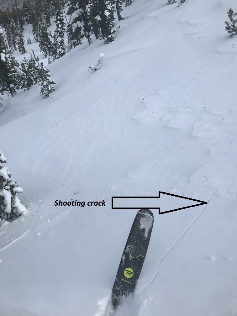
- Shooting cracks
- Scoured terrain, immediately transitioning to drum-like, hollow wind pillows
Communicate with your group and use safe travel practices such as "one at a time" where problematic wind slabs may exist. Wind slabs can "pop" off without warning. Tread lightly today.
Forecast Discussion
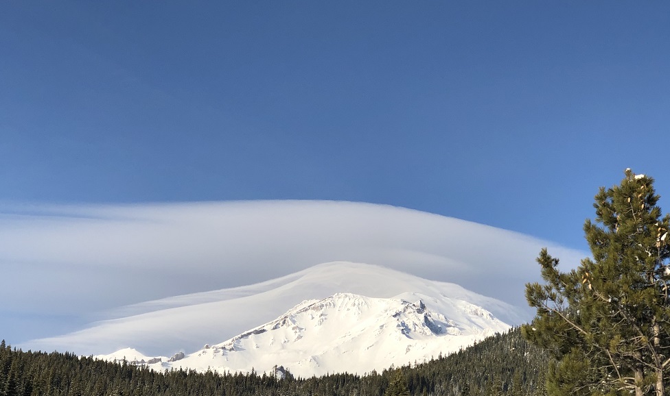
Lenticular clouds are stationary clouds that form mostly in the troposphere and are typically in perpendicular alignment to the wind direction. The short of it is, if you see a lenticular cloud on Mount Shasta, it's certain that high winds exist! This beauty was taken from the Mt. Shasta Ski Park yesterday (12.28) by Sean Malee.
Recent Observations
- Wind speed and direction recorded on Gray Butte (8,000 feet) over the past 24 hours: Average speed 15 mi/hr - N/NW shifting to SW/SE; Gusts 44 to 61 mi/hr - N/NW
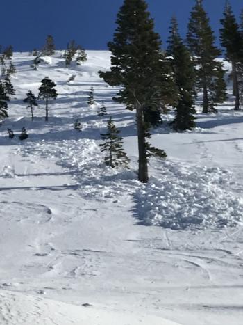
- A natural, wind slab avalanche (D1.5) was witnessed at 1130 hours off Green Butte/Broadway into Avalanche Gulch, a NW/W facing aspect cross-loaded by winds. Estimated crown height: 18 inches / Estimated width: 100 feet - This slide ran down through sparse trees near treeline. (Observation & photos here)
- At Castle Lake, moderate to strong northwest wind was observed near the noon hour. Shooting cracks and small slabs were easily triggered on small test slopes. Protected areas still held soft snow with surface hoar.
- Ridgelines and any exposed terrain have been completely stripped of the 6-10 inches of low density snow that previously existed. Remaining is the slide-for-life, December 19th ice crust. This crust is seriously dangerous if encountered in steep terrain.
- Exposed rock features in alpine terrain are crusted in rime ice.
- Well developed surface hoar observed below treeline in protected, low lying areas near Bunny Flat and Castle Lake.
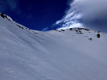
Sorry about the sideways camera angle, but here is a real good look at the slide-for-life ice crust we've been talking about. It's no joke! This 1/4 inch thick ice layer formed from freezing fog/rain late on the eve of December 19th. It is now exposed in many areas near and above treeline from the NW wind event. Poorly bonded wind slabs, 1-4 feet deep, rest on top of this layer currently.
Weather and Current Conditions
Weather Summary
For today, expect a mix of sunshine and high clouds beginning to float through. In alpine terrain, breezy conditions are likely on exposed topography. Gradually building clouds this afternoon will be the precursor associated with precipitation set to arrive Sunday morning. Precipitation will progress inland on Sunday and bring light to moderate water amounts, about .2 inches for Mount Shasta. Snow levels are near 5,000 feet. A couple inches of fresh snow is probable by the end of the weekend. Light to moderate wind out of the north today will swing around to the west tonight and southwest tomorrow.
24 Hour Weather Station Data @ 3:00 AM
| Weather Station | Temp (°F) | Wind (mi/hr) | Snow (in) | Comments | ||||||||
|---|---|---|---|---|---|---|---|---|---|---|---|---|
| Cur | Min | Max | Avg | Avg | Max Gust | Dir | Depth | New | Water Equivalent | Settlement | ||
| Mt. Shasta City (3540 ft) | 29 | 22 | 40 | 29 | 2 | N | ||||||
| Sand Flat (6750 ft) | 25 | 24 | 32 | 27 | 40 | 0 | 0 | 0 | ||||
| Ski Bowl (7600 ft) | 30 | 28.5 | 40 | 34.5 | 45.1 | 0 | 0 | 5 | wind blew 5 in. snow away | |||
| Gray Butte (8000 ft) | 30 | 29.5 | 36.5 | 32.5 | 15 | 61 | N | |||||
| Castle Lake (5870 ft) | 0 | 0 | 0 | 0 | 0 | 0 | 0 | down | ||||
| Mount Eddy (6509 ft) | 33 | 24.5 | 36 | 32 | 3 | 16 | SE | 33.5 | 0 | 1 | ||
| Ash Creek Bowl (7250 ft) | down | |||||||||||
| Ash Creek Ridge (7895 ft) | down |
Two Day Mountain Weather Forecast
Produced in partnership with the Medford NWS
| For 7000 ft to 9000 ft | |||
|---|---|---|---|
|
Saturday (4 a.m. to 10 p.m.) |
Saturday Night (10 p.m. to 4 a.m.) |
Sunday (4 a.m. to 10 p.m.) |
|
| Weather | Partly sunny | Chance of snow after 4am, cloudy. Chance of precipitation 30%. Snow level near 6,300 feet. | Mostly cloudy, snow, mainly after 10am. Chance of precipitation 90%. Snow level near 5,000 feet |
| Temperature (°F) | 40 | 27 | 28 |
| Wind (mi/hr) | North 5-10 | West 0-5 | South 0-5 |
| Precipitation SWE / Snowfall (in) | 0.00 / 0 | 0.00 / 0-0.50 | 0.20 / 2-4 |
| For 9000 ft to 11000 ft | |||
| Saturday | Saturday Night | Sunday | |
| Weather | Partly sunny and windy. | Mostly cloudy, chance of snow after 4am. | Snow, mainly after 10am. Breezy. |
| Temperature (°F) | 27 | 19 | 21 |
| Wind (mi/hr) | North 20-30 | West 10-20 | Southwest 10-20 |
| Precipitation SWE / Snowfall (in) | 0.00 / 0 | 0.00 / 0-0.50 | 0.20 / 2-4 |
Season Precipitation for Mount Shasta City
| Period | Measured (in) | Normal (in) | Percent of Normal (%) |
|---|---|---|---|
| From Oct 1, 2025 (the wet season) | 8.90 | 14.19 | 63 |
| Month to Date (since Jun 1, 2026) | 6.22 | 6.83 | 91 |
| Year to Date (since Jan 1, 2026) | 46.64 | 42.19 | 111 |

