

You are here
Avalanche Forecast for 2019-12-29 06:30
- EXPIRED ON December 30, 2019 @ 6:30 amPublished on December 29, 2019 @ 6:30 am
- Issued by Aaron Beverly - Mount Shasta Avalanche Center
Bottom Line
Small, human-triggered avalanches are possible later today and tonight as new snow combines with west and north winds to create wind slabs on top of a wide spread rain crust. Though unlikely to bury a person, these slides could take the off-guard skier into dangerous terrain. An ice axe and crampons are mandatory for climbers and know that self-arrest will be difficult.


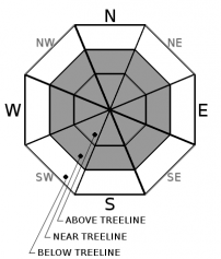
Avalanche Problem 1: Wind Slab
-
Character ?

-
Aspect/Elevation ?
-
Likelihood ?CertainVery LikelyLikelyPossible
 Unlikely
 -
Size ?HistoricVery LargeLargeSmall

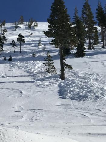
The wind slab issue seen on Friday has mostly diminished as high winds have left the snowpack scoured. Small, isolated wind slabs could still be encountered in lee areas.
Up to three inches of snow today combined with west and north winds will create new, small wind slabs sitting on top of a smooth, slippery rain crust. These will be small and probably not big enough to bury someone, but could take the unwary skier off guard and into dangerous terrain or on a slide-for-life ride. Avoid terrain over 35 degrees.
Blowing snow, cracking and blocking, and hollow sounding drifts are signs that wind slabs are forming.
Forecast Discussion
The new snow expected in the next 24 hours will create a dust on crust configuration. Be prepared to get your feet swept out from under you on steep slopes. If ascending into the alpine, an ice axe and crampons are mandatory. Self arresting on the burly crust out there will be difficult.
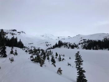
Recent Observations
In the last 24 hours on Mount Shasta, temperatures have ranged from 30 to 41°F. Winds were calm maxing out at 4 mi/hr.
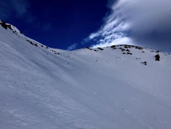
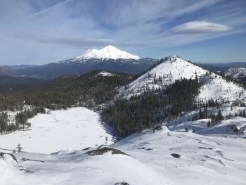
Near and above treeline, winds from the day prior have left the snowpack scoured down to the 12/19 rain crust in open areas and start zones. Pockets of wind packed sastrugi and drifts were seen in more protected areas. No cracking or blocking or other wind slab indicators were encountered. Very little snow remains for transport. Warmer temperatures have created a thin crust below treeline.
A weak layer still persists at Castle Lake below the rain crust. It would take a lot of weight or force to make this an issue, but it is worth continued monitoring. Overall the snowpack is well anchored. Some cracking was observed but wind slabs were small and isolated. Decent skiing conditions were encountered on northwest aspects.
Weather and Current Conditions
Weather Summary
Speaking optimistically, we may see up to 3 inches of snow above 4,000 ft today and tonight as a front moves into the region. Winds will be light to moderate, switching from the south to north.
Things will dry out tomorrow, but an active weather pattern will continue into the extended forecast with more snow likely on New Year's Day and then Friday and Saturday. Snow amounts on New Year's will be minimal.
24 Hour Weather Station Data @ 5:00 AM
| Weather Station | Temp (°F) | Wind (mi/hr) | Snow (in) | Comments | ||||||||
|---|---|---|---|---|---|---|---|---|---|---|---|---|
| Cur | Min | Max | Avg | Avg | Max Gust | Dir | Depth | New | Water Equivalent | Settlement | ||
| Mt. Shasta City (3540 ft) | 37 | 32 | 46 | 36.5 | 1 | N | ||||||
| Sand Flat (6750 ft) | 32 | 27 | 38 | 32 | 40 | 0 | 0 | 1 | ||||
| Ski Bowl (7600 ft) | 31 | 30.5 | 41 | 34 | 44.8 | 0 | 0 | 1 | ||||
| Gray Butte (8000 ft) | 28.5 | 28.5 | 39 | 33 | 1 | 12 | ||||||
| Castle Lake (5870 ft) | down | |||||||||||
| Mount Eddy (6509 ft) | 33 | 33 | 40 | 36.5 | 2 | 11 | WSW | 32.7 | 0 | 1 | ||
| Ash Creek Bowl (7250 ft) | down | |||||||||||
| Ash Creek Ridge (7895 ft) | down |
Two Day Mountain Weather Forecast
Produced in partnership with the Medford NWS
| For 7000 ft to 9000 ft | |||
|---|---|---|---|
|
Sunday (4 a.m. to 10 p.m.) |
Sunday Night (10 p.m. to 4 a.m.) |
Monday (4 a.m. to 10 p.m.) |
|
| Weather | Snow, mainly after 10 a.m. Chance of precipitation is 100%. | Snow showers before 10 p.m. Chance of precipitation is 90%. | Sunny. |
| Temperature (°F) | 29 | 24 | 33 |
| Wind (mi/hr) | South 5-10 | Northeast 5-10 | Northeast 5-10 |
| Precipitation SWE / Snowfall (in) | 0.11 / 0.50-1 | 0.09 / 0.50-1 | 0.00 / 0 |
| For 9000 ft to 11000 ft | |||
| Sunday | Sunday Night | Monday | |
| Weather | Snow, mainly after 10 a.m. Winds decreasing in the morning. Chance of precipitation is 100%. | Snow showers before 10 p.m. Chance of precipitation is 90%. | Sunny. Increasing winds. Gusty. |
| Temperature (°F) | 23 | 20 | 30 |
| Wind (mi/hr) | Southwest 15-20 | North 10-15 | Northeast 20-25 |
| Precipitation SWE / Snowfall (in) | 0.11 / 0.50-2 | 0.09 / 0.50-1 | 0.00 / 0 |
Season Precipitation for Mount Shasta City
| Period | Measured (in) | Normal (in) | Percent of Normal (%) |
|---|---|---|---|
| From Oct 1, 2025 (the wet season) | 8.90 | 14.45 | 62 |
| Month to Date (since Jun 1, 2026) | 6.22 | 7.09 | 88 |
| Year to Date (since Jan 1, 2026) | 46.64 | 42.45 | 110 |

