

You are here
Avalanche Forecast for 2020-01-31 05:23
- EXPIRED ON February 1, 2020 @ 5:23 amPublished on January 31, 2020 @ 5:23 am
- Issued by Nick Meyers - Shasta-Trinity National Forest
Bottom Line
The avalanche danger is LOW for all aspects/elevations today and normal caution is advised. Windy conditions will continue in high, alpine terrain.
Exposed rocks on Mount Shasta are plastered with rime ice. Warm daytime temperatures will allow small to large chunks of rime to cut loose onto skiers and climbers below. Getting hit with a solid chunk of ice can be like a rock! Wear a helmet or better yet, avoid slopes beneath rime covered rock features.


Avalanche Problem 1: Normal Caution
-
Character ?

-
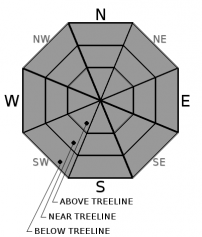
Aspect/Elevation ?
-
Likelihood ?CertainVery LikelyLikelyPossible
 Unlikely
 -
Size ?HistoricVery LargeLargeSmall

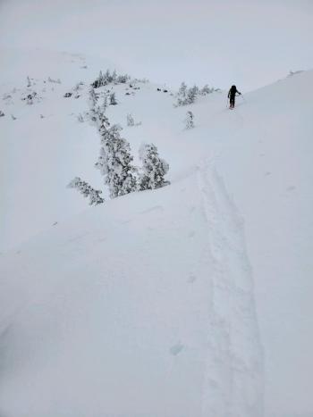
Normal caution should be standard for all winter backcountry adventures, any day of the season. This means checking the avalanche forecast, doing a beacon check at the trailhead and traveling wisely through avalanche terrain, like one at a time crossing steep slopes or avalanche paths while everyone watches from safe zones.
Always pay attention to the 5 red flags of avalanche danger: Recent avalanches, shooting cracks or whoompfing, heavy snowfall, wind drifting and rapid warming/rain.
Forecast Discussion
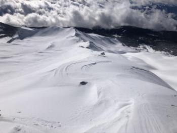
Watch for falling RIME ICE. Due to warm temperatures, chunks of rime like the one pictured below are certain to be tumbling down Mount Shasta's slopes today. A local skier was already smacked yesterday.
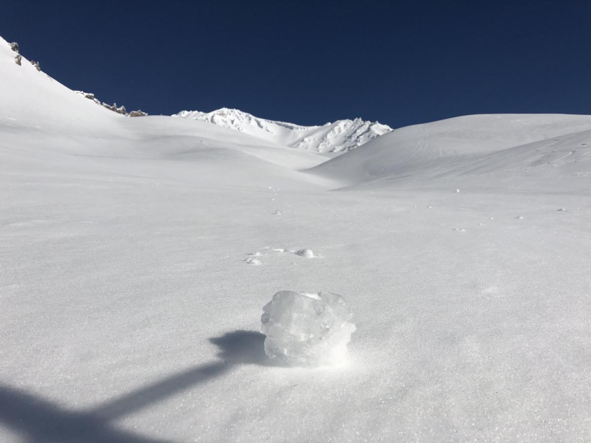
[Photo: S Malee - 1.30.20 - Avalanche Gulch, below 50/50 Flat]
Recent Observations
- Despite a gorgeous, sunny day, conditions were variable and challenging at times on Mount Shasta yesterday. A public observation from Avalanche Gulch, up to 11,500 feet, noted very windy conditions from multiple directions during the day. From 50/50 to Lake Helen was noted as "horrible". Glazed, marble-like snow surfaces were very difficult to skin up and the boot packing wasn't much better due to post-holing. Above Lake Helen, some moments of brilliance were found with soft, wind pressed snow in some areas. Active, falling rime ice was observed. Lower down on the mountain, transitional snow had some corn-like characteristics that skied decently.
- At Castle Lake, it was sun's out, guns out. Warm, spring-like conditions were observed with almost ripe corn snow on southerly aspects. In the shade was a bit crusty. The snowpack is actively melting and shallow up there, only about 30 inches (76 centimeters) average depth. Bare ground around trees is showing.The lake is still frozen, a bit mushy, but otherwise supportable. Of note, the Castle Lake weather station is back online! After a storied few months, we've successfully repaired the station. Thumbs up!
- Evidence of wind slabs and/or other signs of unstable snow was hard to come by yesterday. Warm temperatures have settled out the snowpack several inches and available snow for wind transport is minimal. Our current snowpack is plastered onto the landscape pretty darn well. Now we wait for more snow...because just like money, it never seems to be enough.
Weather and Current Conditions
Weather Summary
Low clouds and fog in the valleys this morning should burn off and give way to a pretty dang nice day. If you were out yesterday, it felt spring-like and today will feel even more so with temps a few degrees warmer. Don't get accustomed to the balmy weather. The pattern will change tonight as increasing clouds will arrive ahead of the next frontal system that will move through the area this weekend. Cold arctic air will push down from the north Saturday afternoon. Snow levels will be around 6,000 feet during the day, dropping sharply to valley floors by Sunday morning. Precipitation values for Mount Shasta don't look impressive at this point...only about .08" snow-water equivalent which could mean a few inches of snow. Better than a sharp stick to the eye as our variable snowpack could use a little Zamboni action.
24 Hour Weather Station Data @ 3:00 AM
| Weather Station | Temp (°F) | Wind (mi/hr) | Snow (in) | Comments | ||||||||
|---|---|---|---|---|---|---|---|---|---|---|---|---|
| Cur | Min | Max | Avg | Avg | Max Gust | Dir | Depth | New | Water Equivalent | Settlement | ||
| Mt. Shasta City (3540 ft) | 37 | 30 | 47 | 39.5 | 1 | N | ||||||
| Sand Flat (6750 ft) | 32 | 32 | 42 | 36 | 52 | 0 | 1 | 158 | ||||
| Ski Bowl (7600 ft) | 43.5 | 31 | 43.5 | 36.5 | 69.1 | 0 | 0 | 2.7 | ||||
| Gray Butte (8000 ft) | 41 | 30.5 | 41 | 35 | 7 | 25 | E | |||||
| Castle Lake (5870 ft) | 40 | 36 | 43 | 39.5 | 30.8 | 0 | 0 | |||||
| Mount Eddy (6509 ft) | 36 | 30.5 | 44.5 | 38 | 2 | 9 | WSW | 47.4 | 0 | 2.5 | ||
| Ash Creek Bowl (7250 ft) | down | |||||||||||
| Ash Creek Ridge (7895 ft) | down |
Two Day Mountain Weather Forecast
Produced in partnership with the Medford NWS
| For 7000 ft to 9000 ft | |||
|---|---|---|---|
|
Friday (4 a.m. to 10 p.m.) |
Friday Night (10 p.m. to 4 a.m.) |
Saturday (4 a.m. to 10 p.m.) |
|
| Weather | Mostly sunny | Partly cloudy | Mostly sunny. Chance of rain and snow after 4 PM. Snow levels near 6,400 feet. |
| Temperature (°F) | 52 | 33 | 46 |
| Wind (mi/hr) | Northwest 0-5 | Southwest 5-10 | South 10-15 |
| Precipitation SWE / Snowfall (in) | 0.00 / 0 | 0.00 / 0 | 0.02 / 0 |
| For 9000 ft to 11000 ft | |||
| Friday | Friday Night | Saturday | |
| Weather | Mostly sunny and windy | Partly cloudy and windy | Mostly sunny, temperatures falling, windy. |
| Temperature (°F) | 37 | 35 | 35 |
| Wind (mi/hr) | West 20-30 | Southwest 20-30 | Southwest 30-40 |
| Precipitation SWE / Snowfall (in) | 0.00 / 0 | 0.00 / 0 | 0.02 / 0 |
Season Precipitation for Mount Shasta City
| Period | Measured (in) | Normal (in) | Percent of Normal (%) |
|---|---|---|---|
| From Oct 1, 2025 (the wet season) | 12.78 | 22.06 | 58 |
| Month to Date (since Jun 1, 2026) | 3.85 | 6.85 | 56 |
| Year to Date (since Jan 1, 2026) | 3.85 | 6.85 | 56 |

