

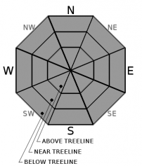
You are here
Avalanche Forecast for 2020-02-10 06:30
- EXPIRED ON February 11, 2020 @ 6:30 amPublished on February 10, 2020 @ 6:30 am
- Issued by Ryan Sorenson - Mount Shasta Avalanche Center
Bottom Line
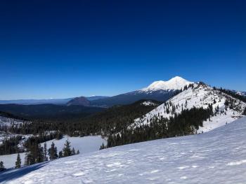
Snow surfaces are firm and variable. Avalanche danger is LOW for all elevations and aspects. The main concern is that a slip or fall on steep icy slopes could be difficult to arrest. Wear a helmet, carry an ice axe and crampons, and continue to watch for falling ice if traveling above treeline on Mount Shasta. Expect strong northeast wind near and above treeline.


Avalanche Problem 1: Normal Caution
-
Character ?

-
Aspect/Elevation ?
-
Likelihood ?CertainVery LikelyLikelyPossible
 Unlikely
 -
Size ?HistoricVery LargeLargeSmall

Normal caution is advised. Always carry the proper equipment such as a beacon, shovel, and probe. An ice axe, crampons, and helmet are necessary if planning on traveling above treeline on Mount Shasta. Snow surfaces are firm and variable. Lower elevations could see modest softening of snow surfaces in sunny areas, but shady slopes and higher elevations will remain firm and crusty.
Forecast Discussion
Climbers interested in ascending Mount Shasta this week will need to be prepared for firm, icy, and very windy conditions. Solid ice axe, crampon, and self-arrest skills mandatory. You need a Mt Shasta Wilderness summit pass if traveling above 10,000 feet, even if you don't plan on going to the summit. A wilderness permit and human waste packout bag are also required. All of these items are available for self-issue at the Bunny Flat trailhead or Mount Shasta Ranger Station. Annual passes ($30) are only available at the ranger station during business hours (Mon-Fri, 8 AM-4:30 PM).
Don't let the LOW danger rating lull you into complacency. It is essential to be familiar with your gear. Always check that your equipment is in proper functioning order BEFORE you leave the trailhead. Below is a video produced by the American Mountain Guides Association showing how to perform an avalanche beacon function check.
Recent Observations
Strong winds out of the northeast continue to keep existing snow surfaces firm and icy. Little change in the snowpack has occurred. Hard wind glazed and slippery snow surfaces remain.
Over the last 24 hours, daytime temperatures have remained mostly below freezing. A temperature inversion has built overnight. Currently (5 AM), it is 38°F at 8,000 feet on Mount Shasta and 32°F at 3,500 feet in Mount Shasta City. Steady, strong northeast winds averaging 23 mi/hr continue to blow. Gray Butte recorded an average temperature of 31°F at 8,000 feet.


Weather and Current Conditions
Weather Summary
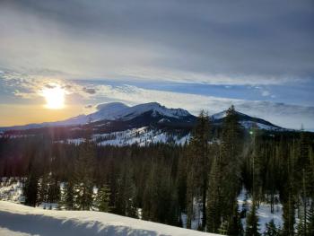
Today's weather, similar to yesterday, will be full of sunshine and wind as high pressure continues to dig in over Northern California and Oregon. Strong winds will be out of the northeast today. Daytime high temperatures will reach the mid to high 30's. The northerly wind will allow temperatures to drop to the upper 20's tonight. Warm and dry weather will continue until Thursday.
As of now, satellite and radar are showing that the storm scheduled to arrive on Thursday morning could bring some much-needed snow to the area. Unfortunately, the high-pressure ridge currently in place will block and use up much of the available energy in this storm. The snow flurries that make there way through will be light as .14 inches of available water precipitates out. It is early to tell, but snow levels are looking to be near 6,000 feet.
24 Hour Weather Station Data @ 5:00 AM
| Weather Station | Temp (°F) | Wind (mi/hr) | Snow (in) | Comments | ||||||||
|---|---|---|---|---|---|---|---|---|---|---|---|---|
| Cur | Min | Max | Avg | Avg | Max Gust | Dir | Depth | New | Water Equivalent | Settlement | ||
| Mt. Shasta City (3540 ft) | 32 | 28 | 44 | 36.5 | 4 | |||||||
| Sand Flat (6750 ft) | 25 | 15 | 29 | 23 | 50 | 0 | 0 | 0 | ||||
| Ski Bowl (7600 ft) | 41.5 | 18.5 | 42.5 | 34.5 | 65 | 0 | 0 | 1 | ||||
| Gray Butte (8000 ft) | 39.5 | 17 | 39.5 | 31.5 | 23 | 49 | NE | |||||
| Castle Lake (5870 ft) | 29.5 | 18 | 32.5 | 26.5 | 31 | 0 | 0 | |||||
| Mount Eddy (6509 ft) | 32.5 | 17.5 | 34 | 29 | 3 | 15 | SSW | 48 | 0 | 0 | ||
| Ash Creek Bowl (7250 ft) | down | |||||||||||
| Ash Creek Ridge (7895 ft) | down |
Two Day Mountain Weather Forecast
Produced in partnership with the Medford NWS
| For 7000 ft to 9000 ft | |||
|---|---|---|---|
|
Monday (4 a.m. to 10 p.m.) |
Monday Night (10 p.m. to 4 a.m.) |
Tuesday (4 a.m. to 10 p.m.) |
|
| Weather | Sunny and breezy | Clear | Sunny |
| Temperature (°F) | 40 | 28 | 42 |
| Wind (mi/hr) | Northeast 10-15 | Northeast 10-15 | Northeast 10-15 |
| Precipitation SWE / Snowfall (in) | 0.00 / 0 | 0.00 / 0 | 0.00 / 0 |
| For 9000 ft to 11000 ft | |||
| Monday | Monday Night | Tuesday | |
| Weather | Sunny, windy | Clear, windy | Sunny, windy |
| Temperature (°F) | 32 | 28 | 34 |
| Wind (mi/hr) | Northeast 30-35 | Northeast 30-35 | Northeast 35-40 |
| Precipitation SWE / Snowfall (in) | 0.00 / 0 | 0.00 / 0 | 0.00 / 0 |
Season Precipitation for Mount Shasta City
| Period | Measured (in) | Normal (in) | Percent of Normal (%) |
|---|---|---|---|
| From Oct 1, 2025 (the wet season) | 12.90 | 24.46 | 53 |
| Month to Date (since Jun 1, 2026) | 0.12 | 2.19 | 5 |
| Year to Date (since Jan 1, 2026) | 3.97 | 9.25 | 43 |

