

You are here
Avalanche Forecast for 2020-02-14 06:40
- EXPIRED ON February 15, 2020 @ 6:40 amPublished on February 14, 2020 @ 6:40 am
- Issued by Nick Meyers - Shasta-Trinity National Forest
Bottom Line
LOW avalanche danger exists with normal caution advised. Snow surfaces below 10,000 feet with direct sun exposure will soften during the afternoon hours. Firm snow surfaces in upper elevation terrain will present a sliding fall hazard. Pay extra close attention where firm, icy slopes terminate into exposed rock.


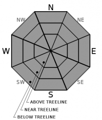
Avalanche Problem 1: Normal Caution
-
Character ?

-
Aspect/Elevation ?
-
Likelihood ?CertainVery LikelyLikelyPossible
 Unlikely
 -
Size ?HistoricVery LargeLargeSmall

Temperatures dropped below freezing last night. A decent surface refreeze is expected to have occurred. Anticipate firm snow surfaces this morning, gradually softening in areas of direct sun exposure and free of wind, primarily below 10,000 feet. Wind exposed and/or higher elevation slopes may remain firm all day, even if exposed to the sun. Northerly aspects will see minimal to no melt. Sliding falls on firm snow surfaces remain a concern. Think about this hazard and the associated travel plan for steep and firm snow surfaces. It would be easy to find yourself in an undesirable position in steep terrain.
Forecast Discussion
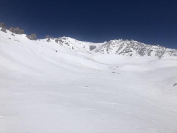
Happy Valentine's Day! It's been 15 days since our last drop of precipitation. Not very loving of Mother Nature. For the month of February, Mount Shasta City has observed .12" of water, normal is 3.14", only 4% of normal. Large, scoured patches of exposed rock exist on the mountain despite an average snow depth of 3 to 5 feet (152 centimeters) of snow.
Recent Observations
- The snowpack continues to settle out. Soft corn snow can be found in select areas below 10,000 feet
- Wind textured snow on ridges and moraine tops, very firm
- Smooth snow easy to find
- Dirt and cinder debris collecting in low-lying areas, gullies.
- Rime and rock fall minimal yesterday with light and variable wind
- No signs of avalanche danger
Weather and Current Conditions
Weather Summary
More clear, dry, cool and breezy weather today. The next wave will move in Saturday night into Sunday, first with a warm front and then a trailing cold front. Precipitation will be minimal for the area. Snow levels will start near 6,500 feet Saturday evening and fall to 4,500 feet by Sunday morning. Only a couple hundredths of an inch of water (.03") is showing at this time, merely a skiff of snow for the mountains. Wind will be a factor over higher terrain. Next week, northeasterly flow digs in with no major storms in the forecast.
24 Hour Weather Station Data @ 5:00 AM
| Weather Station | Temp (°F) | Wind (mi/hr) | Snow (in) | Comments | ||||||||
|---|---|---|---|---|---|---|---|---|---|---|---|---|
| Cur | Min | Max | Avg | Avg | Max Gust | Dir | Depth | New | Water Equivalent | Settlement | ||
| Mt. Shasta City (3540 ft) | 29 | 23 | 55 | 39.5 | 2 | N | ||||||
| Sand Flat (6750 ft) | 31 | 26 | 42 | 33 | 48 | 0 | 0 | 1 | ||||
| Ski Bowl (7600 ft) | 26.5 | 26.5 | 44 | 34 | 64 | 0 | 0 | 1 | ||||
| Gray Butte (8000 ft) | 26 | 25.5 | 38 | 32 | 12 | 31 | WNW | |||||
| Castle Lake (5870 ft) | 29.5 | 29.5 | 49.5 | 37.5 | 30.5 | 0 | 0 | |||||
| Mount Eddy (6509 ft) | 26.5 | 26.5 | 47 | 34.5 | 2 | 6 | WSW | 46 | 0 | 0 | ||
| Ash Creek Bowl (7250 ft) | down | |||||||||||
| Ash Creek Ridge (7895 ft) | down |
Two Day Mountain Weather Forecast
Produced in partnership with the Medford NWS
| For 7000 ft to 9000 ft | |||
|---|---|---|---|
|
Friday (4 a.m. to 10 p.m.) |
Friday Night (10 p.m. to 4 a.m.) |
Saturday (4 a.m. to 10 p.m.) |
|
| Weather | Mostly sunny | Partly cloudy | Partly sunny, chance of snow after 4PM |
| Temperature (°F) | 40 | 26 | 42 |
| Wind (mi/hr) | Northwest 5-10 | Northwest 5-10 | Southwest 5-10 |
| Precipitation SWE / Snowfall (in) | 0.00 / 0 | 0.00 / 0 | 0.01 / 0 |
| For 9000 ft to 11000 ft | |||
| Friday | Friday Night | Saturday | |
| Weather | Mostly sunny and windy | Partly cloudy and windy | Partly sunny and windy, chance of snow after 4PM |
| Temperature (°F) | 26 | 24 | 25 |
| Wind (mi/hr) | Northwest 20-30 | Northwest 20-30 | West 30-40 |
| Precipitation SWE / Snowfall (in) | 0.00 / 0 | 0.00 / 0 | 0.01 / 0 |
Season Precipitation for Mount Shasta City
| Period | Measured (in) | Normal (in) | Percent of Normal (%) |
|---|---|---|---|
| From Oct 1, 2025 (the wet season) | 12.90 | 25.41 | 51 |
| Month to Date (since Jul 1, 2026) | 0.12 | 3.14 | 4 |
| Year to Date (since Jan 1, 2026) | 3.97 | 10.20 | 39 |

