

You are here
Avalanche Forecast for 2020-02-16 06:30
- EXPIRED ON February 17, 2020 @ 6:30 amPublished on February 16, 2020 @ 6:30 am
- Issued by Aaron Beverly - Mount Shasta Avalanche Center
Bottom Line
Avalanche danger is LOW. Though a bit of snow is expected today below 5,500 ft, clear, dry weather will dominate for the foreseeable future. Be prepared for a firm snowpack. Bring an ice axe, crampons, and helmet if ascending high into the alpine.


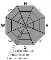
Avalanche Problem 1: Normal Caution
-
Character ?

-
Aspect/Elevation ?
-
Likelihood ?CertainVery LikelyLikelyPossible
 Unlikely
 -
Size ?HistoricVery LargeLargeSmall

Use your common sense in the backcountry. Carry the proper equipment for avalanche rescue: a beacon, shovel, and probe.
Don't let dust on crust conditions deceive you. Expect firm conditions above treeline. Bring an ice axe, crampons, and helmet if ascending steep slopes.
If prolonged, above freezing temperatures are experienced, beware of rock fall above Helen Lake.
Recent Observations
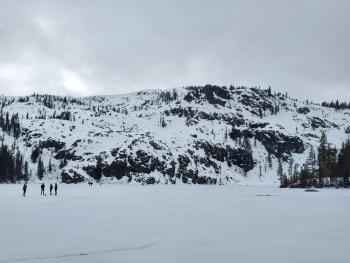
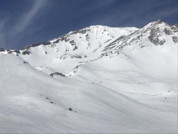
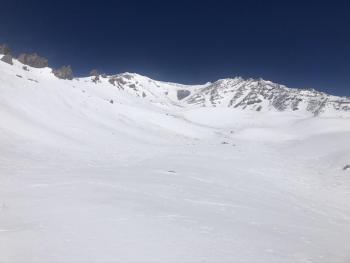
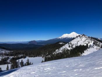
In the last 24 hours, Mount Shasta has received no new snow. Temperatures have been mostly near or below freezing, ranging from 26 to 36 degrees F. Northwest winds have been moderate to strong.
The snowpack is taking on late spring characteristics - shallow, firm, and sun-cupped, with old wind textures. Cinders, twigs, and other detritus from wind events litter the snow surface. Recent signs of rock fall is evident above Helen Lake.
No signs of instability have been seen.
Weather and Current Conditions
Weather Summary
The back end of a warm front will bring some light precipitation today. With snow levels dropping, we might see some flurries at elevations that we like to see them, but less than 1/2 an inch is expected. Snow levels will start at 5,500 ft and will drop to town by late tonight.
A building long wave ridge off the coast will keep us high and dry until mid-week. An easterly flow of air will then set in, continuing to dry us out until the weekend. Large diurnal ranges in temperatures are expected.
Unfortunately, a reprieve from dry weather is at least 10 days out. Check the California Weather Blog for details.

24 Hour Weather Station Data @ 5:00 AM
| Weather Station | Temp (°F) | Wind (mi/hr) | Snow (in) | Comments | ||||||||
|---|---|---|---|---|---|---|---|---|---|---|---|---|
| Cur | Min | Max | Avg | Avg | Max Gust | Dir | Depth | New | Water Equivalent | Settlement | ||
| Mt. Shasta City (3540 ft) | 38 | 37 | 52 | 44 | 1 | N | ||||||
| Sand Flat (6750 ft) | 32 | 30 | 38 | 34 | 48 | 0 | 0 | 1 | ||||
| Ski Bowl (7600 ft) | 29 | 26 | 36.5 | 31 | 64.4 | 0 | 0.02 | 0 | ||||
| Gray Butte (8000 ft) | 26.5 | 24.5 | 32.5 | 29 | 21 | 49 | NW | |||||
| Castle Lake (5870 ft) | 33.5 | 30 | 42 | 36 | 30.5 | 0 | 0 | |||||
| Mount Eddy (6509 ft) | 31 | 29.5 | 40.5 | 34 | 1 | 12 | SSE | 45.7 | 1.7 | 0 | ||
| Ash Creek Bowl (7250 ft) | down | |||||||||||
| Ash Creek Ridge (7895 ft) | down |
Two Day Mountain Weather Forecast
Produced in partnership with the Medford NWS
| For 7000 ft to 9000 ft | |||
|---|---|---|---|
|
Sunday (4 a.m. to 10 p.m.) |
Sunday Night (10 p.m. to 4 a.m.) |
Monday (4 a.m. to 10 p.m.) |
|
| Weather | Snow likely before 10 a.m., then a chance of snow showers after 10 a.m. Cloudy, then gradually becoming mostly sunny. Chance of precipitation is 60%. | Partly cloudy. | Sunny. |
| Temperature (°F) | 34 | 21 | 35 |
| Wind (mi/hr) | West 10-15 | Northwest 5-10 | Northeast 5-10 |
| Precipitation SWE / Snowfall (in) | 0.03 / 0-0.50 | 0.00 / 0 | 0.00 / 0 |
| For 9000 ft to 11000 ft | |||
| Sunday | Sunday Night | Monday | |
| Weather | Snow likely before 10 a.m., then a chance of snow showers after 10 a.m. Cloudy, then gradually becoming mostly sunny. Windy and gusty. Low wind chills. Chance of precipitation is 70%. | Partly cloudy. Windy and gusty. Low wind chills. | Sunny. Windy and gusty. Low wind chills. |
| Temperature (°F) | 20 | 8 | 17 |
| Wind (mi/hr) | Northwest 30-35 | Northwest 35-40 | North 25-30 |
| Precipitation SWE / Snowfall (in) | 0.03 / 0-0.50 | 0.00 / 0 | 0.00 / 0 |
Season Precipitation for Mount Shasta City
| Period | Measured (in) | Normal (in) | Percent of Normal (%) |
|---|---|---|---|
| From Oct 1, 2025 (the wet season) | 12.90 | 25.93 | 50 |
| Month to Date (since Jul 1, 2026) | 0.12 | 3.66 | 3 |
| Year to Date (since Jan 1, 2026) | 3.97 | 10.72 | 37 |

