

You are here
Avalanche Forecast for 2020-02-29 06:45
- EXPIRED ON March 1, 2020 @ 6:45 amPublished on February 29, 2020 @ 6:45 am
- Issued by Aaron Beverly - Mount Shasta Avalanche Center
Bottom Line
Avalanche danger is LOW. Be prepared for a firm snowpack. Bring an ice axe, crampons, and helmet if making a summit attempt. It's going to be a gray, cold, windy day.


Avalanche Problem 1: Normal Caution
-
Character ?

-
Aspect/Elevation ?

-
Likelihood ?CertainVery LikelyLikelyPossible
 Unlikely
 -
Size ?HistoricVery LargeLargeSmall

Avalanche danger is LOW. Exercise normal caution. Stay in the habit of bringing your avalanche rescue gear: shovel, probe, and transceiver. Follow best practices for wilderness and backcountry travel. Carry the ten essentials.
Forecast Discussion
Temperatures are dropping as we speak. Concerns for rock fall will diminish today. If climbing the mountain, expect firm conditions. Bring an ice axe, crampons, and helmet and know how to use them. Dress for cold, windy weather.
Recent Observations
Temperatures near treeline on Mount Shasta have dropped from 45 to 28 degrees. West/northwest winds are increasing. Gusts have been up to 25 mi/hr.
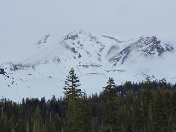
The snowpack is looking like early summer: shallow and dirty, but stable. Some rock fall is evident. A few small point releases have been observed during the warm weather over the last few days, though no new ones were seen yesterday.

Weather and Current Conditions
Weather Summary
Cold air from the north is moving in today. Expect cloudy, windy, and frigid weather. Snow levels will be near town. You might see some flurries, but don't anticipate any accumulation.
Sunny, cold, and windy conditions come tomorrow.
24 Hour Weather Station Data @ 5:00 AM
| Weather Station | Temp (°F) | Wind (mi/hr) | Snow (in) | Comments | ||||||||
|---|---|---|---|---|---|---|---|---|---|---|---|---|
| Cur | Min | Max | Avg | Avg | Max Gust | Dir | Depth | New | Water Equivalent | Settlement | ||
| Mt. Shasta City (3540 ft) | 30 | 30 | 64 | 44.5 | 2 | N | ||||||
| Sand Flat (6750 ft) | 27 | 27 | 48 | 37 | 41 | 0 | 0 | 0 | ||||
| Ski Bowl (7600 ft) | 28 | 28 | 45 | 36.5 | 60.2 | 0 | 0 | 0.5 | ||||
| Gray Butte (8000 ft) | 26 | 26 | 42 | 34.5 | 13 | 25 | WNW | |||||
| Castle Lake (5870 ft) | 25 | 25 | 57.5 | 41 | 27.9 | 0 | 0 | |||||
| Mount Eddy (6509 ft) | 22 | 22 | 47.5 | 37 | 1 | 9 | WSW | 44.4 | 0 | 0 | ||
| Ash Creek Bowl (7250 ft) | down | |||||||||||
| Ash Creek Ridge (7895 ft) | down |
Two Day Mountain Weather Forecast
Produced in partnership with the Medford NWS
| For 7000 ft to 9000 ft | |||
|---|---|---|---|
|
Saturday (4 a.m. to 10 p.m.) |
Saturday Night (10 p.m. to 4 a.m.) |
Sunday (4 a.m. to 10 p.m.) |
|
| Weather | A 20 percent chance of snow showers after 10 a.m. Mostly cloudy. | A 20 percent chance of snow showers before 10 p.m. Mostly cloudy | Sunny. Blustery. |
| Temperature (°F) | 25 | 16 | 27 |
| Wind (mi/hr) | Northwest 5-10 | North 10-15 | North 10-15 |
| Precipitation SWE / Snowfall (in) | 0.00 / 0 | 0.00 / 0 | 0.00 / 0 |
| For 9000 ft to 11000 ft | |||
| Saturday | Saturday Night | Sunday | |
| Weather | A 20 percent chance of snow showers after 10 a.m. Mostly cloudy. Windy. Low wind chills. | A 20 percent chance of snow showers before 10 p.m. Mostly cloudy. Blustery. Low wind chills. | Mostly sunny and cold. Windy. Low wind chills. |
| Temperature (°F) | 19 | 4 | 9 |
| Wind (mi/hr) | West 15-20 | North 15-20 | North 30-35 |
| Precipitation SWE / Snowfall (in) | 0.00 / 0 | 0.00 / 0 | 0.00 / 0 |
Season Precipitation for Mount Shasta City
| Period | Measured (in) | Normal (in) | Percent of Normal (%) |
|---|---|---|---|
| From Oct 1, 2025 (the wet season) | 12.90 | 29.50 | 44 |
| Month to Date (since Jun 1, 2026) | 0.12 | 7.23 | 2 |
| Year to Date (since Jan 1, 2026) | 3.97 | 14.29 | 28 |

