

You are here
Avalanche Forecast for 2020-03-05 06:11
- EXPIRED ON March 6, 2020 @ 6:11 amPublished on March 5, 2020 @ 6:11 am
- Issued by Nick Meyers - Shasta-Trinity National Forest
Bottom Line
Today will be the warmest day of the week. Watch for falling rock and small loose-wet slides. Be prepared for a firm snowpack at upper elevations and/or northerly facing slopes. Bring an ice axe, crampons, and helmet along with proper navigation tools if making a summit attempt. Winter weather will return briefly, Friday night into Saturday.


Avalanche Problem 1: Normal Caution
-
Character ?

-
Aspect/Elevation ?
-
Likelihood ?CertainVery LikelyLikelyPossible
 Unlikely
 -
Size ?HistoricVery LargeLargeSmall

Avalanche danger is LOW. Exercise normal caution. Stay in the habit of bringing your avalanche rescue gear: shovel, probe, and transceiver. Follow best practices for wilderness and backcountry travel. Carry the ten essentials.
If climbing the mountain, be prepared for firm conditions at upper elevations. Bring an ice axe, crampons, and helmet and know how to use them. Beware of small loose-wet slides under warm, sunlit slopes. Expect rockfall at any time.
Forecast Discussion
You need a Mount Shasta summit pass if traveling above 10,000 feet. A wilderness permit and human waste packout bag are also required. All of these items are available for self-issue at the Bunny Flat trailhead or Mount Shasta Ranger Station. Annual passes are available at the ranger station during business hours (Mon-Fri, 8 a.m - 4:30 p.m.) or The 5th Season.
Recent Observations
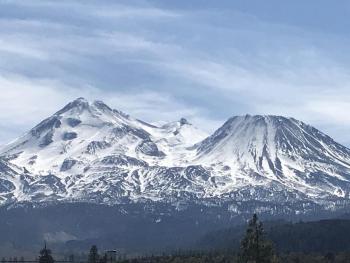
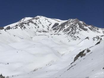
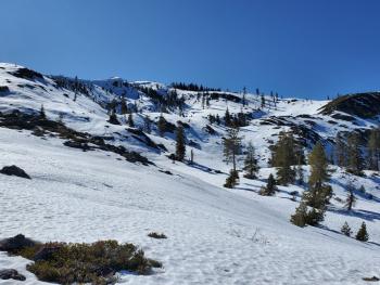
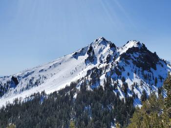
February has been dry, very dry and in fact the driest on record since 1948 (NWS). Despite the looks of it, a handful of nice turns can still be enjoyed on Mount Shasta. The avalanche danger has been stuck on LOW for quite sometime. Overnight re-freeze hasn't been the most stellar as of late, but despite this, snow conditions are still supportable below, near and above treeline throughout the day. All solar exposed aspects softened below 8,500 feet, my high point for the afternoon yesterday. Shady, westerly and northerly aspects were softish, albeit still a bit crusty at 1330 hours. Below treeline, snow surfaces are pretty rough and littered with tree debris. Tree wells are exposed up to +/- 7,500 feet. Near treeline is transitional with smoother snow attained with elevation. Above treeline the smoothest and cleanest snow can be found. With that said, ridgelines are rocky and exposed, as is The Heart and moraine convexities. Dirt and rocks have littered the snowpack in gullies and depressions. Large, exposed patches of rock still exist on all aspects of the mountain. Sun Bowl and Powder Bowl hold soft, pretty smooth corn turns. One can still ski to, and launch from (snowmobiles) Bunny Flat. The weather has been quite nice, winds have been dead calm and temps warm. Don't let a dismal winter get you down. Go soak up some sun. It will snow again, someday.
Weather and Current Conditions
Weather Summary
Today will end up similar to yesterday with mostly sunny skies breaking free once again with the warmest temps of the week. The pattern will begin to change tonight as a deep trough digs southward from BC, bringing a cold front and a bit of precipitation. Southwesterly wind will increase as well. All of this will impact the area Friday night into Saturday. Until then, expect some sun with increasing clouds and wind.
24 Hour Weather Station Data @ 4:00 AM
| Weather Station | Temp (°F) | Wind (mi/hr) | Snow (in) | Comments | ||||||||
|---|---|---|---|---|---|---|---|---|---|---|---|---|
| Cur | Min | Max | Avg | Avg | Max Gust | Dir | Depth | New | Water Equivalent | Settlement | ||
| Mt. Shasta City (3540 ft) | 31 | 31 | 65 | 45.5 | 3 | N | ||||||
| Sand Flat (6750 ft) | 32 | 32 | 51 | 39 | 38 | 0 | 0 | 1 | ||||
| Ski Bowl (7600 ft) | 36.5 | 36.5 | 48.5 | 41.5 | 58 | 0 | 0 | 0.5 | ||||
| Gray Butte (8000 ft) | 36.5 | 36 | 50 | 42 | 3 | 25 | W | |||||
| Castle Lake (5870 ft) | 40.5 | 38 | 56.5 | 45 | 26.6 | 0 | 0.3 | |||||
| Mount Eddy (6509 ft) | 38 | 38 | 49 | 43 | 2 | 6 | WSW | 43.8 | 0 | 0.5 | ||
| Ash Creek Bowl (7250 ft) | down | |||||||||||
| Ash Creek Ridge (7895 ft) | down |
Two Day Mountain Weather Forecast
Produced in partnership with the Medford NWS
| For 7000 ft to 9000 ft | |||
|---|---|---|---|
|
Thursday (4 a.m. to 10 p.m.) |
Thursday Night (10 p.m. to 4 a.m.) |
Friday (4 a.m. to 10 p.m.) |
|
| Weather | Sunny | Mostly cloudy, breezy | Mostly cloudy, 30% chance of snow after 4PM, breezy. Snow level near 5,800 feet. |
| Temperature (°F) | 45 | 32 | 39 |
| Wind (mi/hr) | South 10-15 | South 10-15 | South 10-15 |
| Precipitation SWE / Snowfall (in) | 0.00 / 0 | 0.00 / 0 | 0.11 / 0-0.50 |
| For 9000 ft to 11000 ft | |||
| Thursday | Thursday Night | Friday | |
| Weather | Mostly sunny, windy | Mostly cloudy, windy | Mostly cloudy, windy, a 30% chance of snow after 4PM |
| Temperature (°F) | 28 | 23 | 23 |
| Wind (mi/hr) | Southwest 30-40 | Southwest 35-45 | Southwest 40-50 |
| Precipitation SWE / Snowfall (in) | 0.00 / 0 | 0.00 / 0 | 0.11 / 0-0.50 |
Season Precipitation for Mount Shasta City
| Period | Measured (in) | Normal (in) | Percent of Normal (%) |
|---|---|---|---|
| From Oct 1, 2025 (the wet season) | 12.90 | 30.53 | 42 |
| Month to Date (since Jun 1, 2026) | 0 | 1.03 | 0 |
| Year to Date (since Jan 1, 2026) | 3.97 | 15.32 | 26 |

