

You are here
Avalanche Forecast for 2020-03-06 06:07
- EXPIRED ON March 7, 2020 @ 6:07 amPublished on March 6, 2020 @ 6:07 am
- Issued by Nick Meyers - Shasta-Trinity National Forest
Bottom Line
A winter weather advisory is in effect from 10PM this evening to 10AM PST Saturday above 3,500 feet.
Six to ten inches of new snow is forecast with strong southerly wind. Expect LOW avalanche danger today. MODERATE wind slab avalanche danger is possible by tomorrow morning.


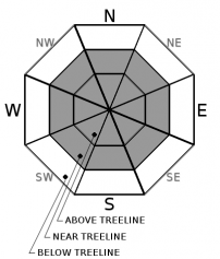
Avalanche Problem 1: Wind Slab
-
Character ?

-
Aspect/Elevation ?
-
Likelihood ?CertainVery LikelyLikelyPossible
 Unlikely
 -
Size ?HistoricVery LargeLargeSmall

New, small to medium-sized wind slabs will be possible by tomorrow morning. The wind forecast indicates southwesterlies blowing 40-50 mi/hr above treeline. The heaviest precipitation is expected early Saturday morning. Should snow totals verify, plenty of fresh snow will be available for wind transport. Watch for newly formed wind slabs on primarily leeward N-NE-E facing slopes and other cross-loaded slopes. Signs like shooting cracks, blocking or cracking within new wind slabs is a sure sign to avoid this terrain and choose a safer line.
Forecast Discussion
After weathering the driest month on record, is anyone even reading this still? Perhaps you are now with fresh snow on the horizon. A quick hitting storm will provide a much-needed refresh to our dirty, haggard snowpack. Good bonding between old and new snow layers is expected due to relatively warm temperatures, but still, lookout for those new wind slabs on steep slopes near/above treeline. Shred safe powder hounds!
Recent Observations
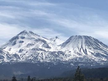
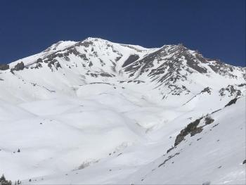
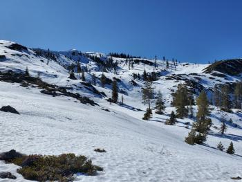
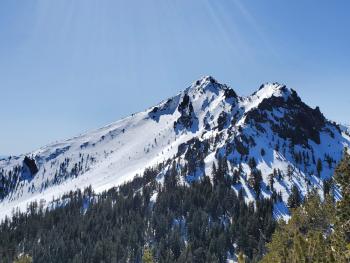
On Mount Shasta, existing snow surfaces leading into the storm are variable. Below treeline, scalloped, dirty snow surfaces dominate with plenty of needles and tree debris littering the snowpack. Tree wells are fully exposed. Near treeline is transitional with smoother snow attained with elevation. Above treeline is a mixed bag of wind hammered snow, exposed rocks, dirt collection in depressions, sun cups and smooth areas as well. In the Castle Lake area, a sad and shallow snowpack exists. Lake ice is untrustworthy. Check recent observation reports/photos for more details.
Weather and Current Conditions
Weather Summary
Mount Shasta is back in the winter game! A brief, but decent little storm will impact the area tonight/tomorrow. A frontal boundary is pushing in from the west today and expected to host moderate to locally heavy snowfall tonight for Bunny Flat and above. Snow levels today will be near 6,100 feet, but should lower to 5,700 feet tonight and 3,500 feet tomorrow. As much as .95" of water is forecast, which could mean a solid 6 to 12 inches of snow. The heaviest precipitation is expected between 10PM and 10AM overnight. South/Southwest wind will continue today, gradually fading into the weekend. High pressure will return Sunday.
24 Hour Weather Station Data @ 5:00 AM
| Weather Station | Temp (°F) | Wind (mi/hr) | Snow (in) | Comments | ||||||||
|---|---|---|---|---|---|---|---|---|---|---|---|---|
| Cur | Min | Max | Avg | Avg | Max Gust | Dir | Depth | New | Water Equivalent | Settlement | ||
| Mt. Shasta City (3540 ft) | 47 | 30 | 63 | 52 | 2 | N | ||||||
| Sand Flat (6750 ft) | 34 | 32 | 49 | 39 | 37 | 0 | 0 | 0 | ||||
| Ski Bowl (7600 ft) | 30.5 | 30.5 | 45 | 37.5 | 58 | 0 | 0 | 0.9 | ||||
| Gray Butte (8000 ft) | 28 | 28 | 41.5 | 35 | 7 | 31 | SW | |||||
| Castle Lake (5870 ft) | 35.5 | 35.5 | 55.5 | 43 | 25.3 | 0 | 0.6 | |||||
| Mount Eddy (6509 ft) | 33.5 | 33.5 | 47 | 40 | 2 | 10 | SSW | 43.1 | 0 | 0.5 | ||
| Ash Creek Bowl (7250 ft) | down | |||||||||||
| Ash Creek Ridge (7895 ft) | down |
Two Day Mountain Weather Forecast
Produced in partnership with the Medford NWS
| For 7000 ft to 9000 ft | |||
|---|---|---|---|
|
Friday (4 a.m. to 10 p.m.) |
Friday Night (10 p.m. to 4 a.m.) |
Saturday (4 a.m. to 10 p.m.) |
|
| Weather | Mostly cloudy, slight chance of rain and snow this morning, then chance of snow after 4PM. Breezy. Snow level near 6,100 feet. | Snow, mainly after 10PM. Snow heavy at times. Snow level near 5,700 feet. | Snow before 10AM, then snow showers diminishing. Snow could be heavy at times. Snow level near 3,500 feet. |
| Temperature (°F) | 40 | 23 | 29 |
| Wind (mi/hr) | South 10-15 | South 10-15 | Southwest 5-10 |
| Precipitation SWE / Snowfall (in) | 0.16 / 0-0.50 | 0.29 / 4-8 | 0.46 / 3-7 |
| For 9000 ft to 11000 ft | |||
| Friday | Friday Night | Saturday | |
| Weather | Slight chance of snow before 10AM, then snow likely after 4PM. Mostly cloudy, windy. | Snow and windy. | Snow before 10AM, then snow showers. Breezy |
| Temperature (°F) | 24 | 12 | 12 |
| Wind (mi/hr) | South 30-40 | South 30-40 | Southwest 15-25 |
| Precipitation SWE / Snowfall (in) | 0.16 / 0-1 | 0.29 / 6-10 | 0.46 / 3-7 |
Season Precipitation for Mount Shasta City
| Period | Measured (in) | Normal (in) | Percent of Normal (%) |
|---|---|---|---|
| From Oct 1, 2025 (the wet season) | 12.90 | 30.77 | 42 |
| Month to Date (since Jun 1, 2026) | 0 | 1.27 | 0 |
| Year to Date (since Jan 1, 2026) | 3.97 | 15.56 | 26 |

