

You are here
Avalanche Forecast for 2020-12-12 06:14
- EXPIRED ON December 13, 2020 @ 6:14 amPublished on December 12, 2020 @ 6:14 am
- Issued by Nick Meyers - Shasta-Trinity National Forest
Bottom Line
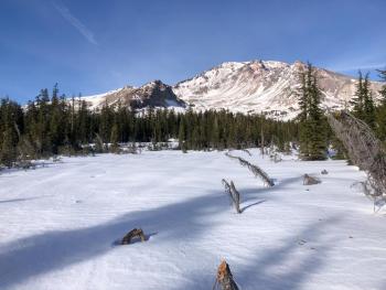
A weak front brought a trace to 2 inches of snow to the area last night. LOW avalanche danger and a thin, early season snowpack will carry on. Watch for rocks and other exposed objects. Normal caution advised.
Expect a break in the weather today. Tonight/tomorrow, a more robust storm should bring measurable snow to the mountains with southerly wind.


Avalanche Problem 1: Normal Caution
-
Character ?

-
Aspect/Elevation ?
-
Likelihood ?CertainVery LikelyLikelyPossible
 Unlikely
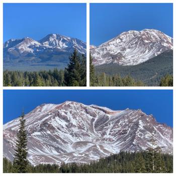
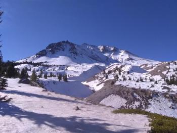
No concern with avalanches today. Early season, thin snowpack conditions continue. Snow surfaces are variable with many rocks. We recommend sticking to roads and gullies for the best snow coverage. Castle Lake does not have a usable snowpack. Climbing Mount Shasta to the top is not advised at this time.
Forecast Discussion
- Winter storms will impact the area over the coming weeks
- Be prepared for winter driving conditions. The Everitt Memorial Highway can be a dangerous, icy road. Go slow. Envision grandma's fresh, frosty cupcakes are sitting on the dash.
- It is still going to take several good storms before early season conditions fade away.
- Rangers have witnessed Christmas tree harvesting from the Bunny Flat area. Cutting trees along the Everitt Memorial Highway and at Bunny Flat is prohibited in most areas. Get a map and be informed.
- As we begin to get snow and see avalanches, help us out by submitting an observation! You can do it right on our website by clicking that big blue button near the obs section. A photo, a few words, anything helps!
Recent Observations
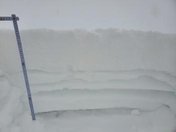
- A thin snowpack dominates the forecast area with many rocks, trees and brush still exposed and ornery as ever.
- A weak, short-lived storm came through last night. At 0500 this morning, it looks like a trace to 2 inches of new snow fell over the area.
- It's been breezy on the mountain, a nice lenticular showing at times yesterday. Wind has been primarily out of the west/northwest with a max gust of 49 mi/hr at 8,000 feet on Gray Butte.
- Temps have been in the teens and twenties F.
Weather and Current Conditions
Weather Summary
Today will be dry and provide a short break in the precipitation department. We might see a little blue sky at times. The next wave of wet weather will begin this evening through Sunday. A more full-bodied storm than last night, we could see up to 7 inches of new snow in the mountains by Monday morning. Snow levels will rise to near 4,200 feet tonight and 4,500 feet on Sunday. Expect windy conditions, northerly this morning switching to southerly this afternoon/evening. A slow start to winter, but what ya gonna do?
24 Hour Weather Station Data @ 5:00 AM
| Weather Station | Temp (°F) | Wind (mi/hr) | Snow (in) | Comments | ||||||||
|---|---|---|---|---|---|---|---|---|---|---|---|---|
| Cur | Min | Max | Avg | Avg | Max Gust | Dir | Depth | New | Water Equivalent | Settlement | ||
| Mt. Shasta City (3540 ft) | 32 | 25 | 40 | 33 | 0 | N | ||||||
| Sand Flat (6750 ft) | 24 | 23 | 29 | 25 | 10 | 2 | 0 | 0 | ||||
| Ski Bowl (7600 ft) | 18.5 | 18.5 | 27 | 21.5 | 14.7 | 2.3 | n/a | 0 | ||||
| Gray Butte (8000 ft) | 17 | 16.5 | 24 | 20 | 15 | 55 | W | |||||
| Castle Lake (5870 ft) | 25.5 | 23 | 33 | 27 | 3 | .6 | 0 | |||||
| Mount Eddy (6509 ft) | 23.5 | 20 | 33.5 | 26.5 | 2 | 6 | ESE | 8.5 | 1.3 | 0 | ||
| Ash Creek Bowl (7250 ft) | 21.5 | 18 | 27.5 | 23.5 | 15.6 | 1.8 | 0 | |||||
| Ash Creek Ridge (7895 ft) | 18 | 12.5 | 25.5 | 21 |
Two Day Mountain Weather Forecast
Produced in partnership with the Medford NWS
| For 7000 ft to 9000 ft | |||
|---|---|---|---|
|
Saturday (4 a.m. to 10 p.m.) |
Saturday Night (10 p.m. to 4 a.m.) |
Sunday (4 a.m. to 10 p.m.) |
|
| Weather | Mostly cloudy with a slight chance of snow this morning, partly sunny later. Blustery. Snow level near 3,500 feet | Breezy, mostly cloudy, snow likely in the evening and snow after midnight. Breezy. Snow level near 4,200 feet. | Snow, breezy. Snow level near 4,500 feet. |
| Temperature (°F) | 31 | 23 | 28 |
| Wind (mi/hr) | Northwest, becoming southeast 5-15 | North 15-25 | South/Southeast 15-25 |
| Precipitation SWE / Snowfall (in) | 0.02 / 0 | 0.12 / 1-2 | 0.63 / 3-7 |
| For 9000 ft to 11000 ft | |||
| Saturday | Saturday Night | Sunday | |
| Weather | Slight chance of snow before 10a.m. Mostly cloudy to partly sunny. Windy. | Mostly cloudy, snow likely. Windy. | Snow, heavy at times. Windy. |
| Temperature (°F) | 33 | 21 | 21 |
| Wind (mi/hr) | Northwest 20-30 | West/Southwest 25-35 | West/Southwest 40-50 |
| Precipitation SWE / Snowfall (in) | 0.02 / 0 | 0.12 / 1-3 | 0.63 / 5-7 |
Season Precipitation for Mount Shasta City
| Period | Measured (in) | Normal (in) | Percent of Normal (%) |
|---|---|---|---|
| From Oct 1, 2025 (the wet season) | 1.73 | 9.93 | 17 |
| Month to Date (since Jul 1, 2026) | 0.03 | 2.57 | 1 |
| Year to Date (since Jan 1, 2026) | 14.64 | 37.93 | 39 |

