

You are here
Avalanche Forecast for 2020-12-13 06:45
- EXPIRED ON December 14, 2020 @ 6:45 amPublished on December 13, 2020 @ 6:45 am
- Issued by Ryan Sorenson - Mount Shasta Avalanche Center
Bottom Line
Avalanche danger will become MODERATE today as fresh snow and strong winds combine to form wind slabs. Human triggered avalanches will be possible. Early season conditions and many hidden obstacles will remain below the fresh snow.


Avalanche Problem 1: Wind Slab
-
Character ?

-
Aspect/Elevation ?
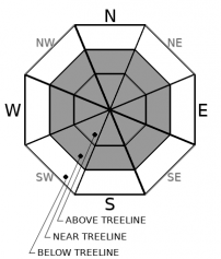
-
Likelihood ?CertainVery LikelyLikelyPossible
 Unlikely
 -
Size ?HistoricVery LargeLargeSmall

Up to 7 inches of new snow and strong southwest winds are predicted today. Fresh snow will combine with the 2 inches remaining from Friday to form new wind slabs. They could grow up to two feet deep on loaded terrain. These newly formed wind slabs may not bond well to the existing snow surfaces. Previous snow surfaces are variable with numerous obstacles. An avalanche terminating in rocky talus, trees, or bushes could have severe consequences.
Shooting cracks, blocking, and hollow sounding snow are signs that wind slabs may be reactive to a human trigger. Identify where wind slabs may exist by paying attention to clues like blowing snow, cornices above a slope, snowdrifts, and wind created surface textures. Adjust travel plans to minimize exposure to potential wind slabs. A probe, shovel, and avalanche transceiver are mandatory. Know how to use them.
Forecast Discussion
- It's going to be rowdy out there today. Winds could reach gale force speeds. Blowing snow, low visibility and bone-chilling winds will make travel difficult.
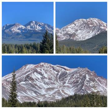
- The new snow has made the rocks and other obstacles harder to see and easier to hit and it is going to take several good storms before early season conditions fade away.
- Be prepared for winter driving conditions. The Everitt Memorial Highway can be a dangerous, icy road.
- Rangers have witnessed Christmas tree harvesting from the Bunny Flat area. Cutting trees along the Everitt Memorial Highway and at Bunny Flat is prohibited in most areas. Get a map and be informed.
- As we begin to get snow and see avalanches, help us out by submitting an observation! You can do it right on our website by clicking that big blue button near the obs section. A photo, a few words, anything helps!
Recent Observations
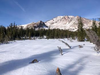
- In the last 24 hours on Mount Shasta, no snow accumulation has been measured.
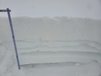
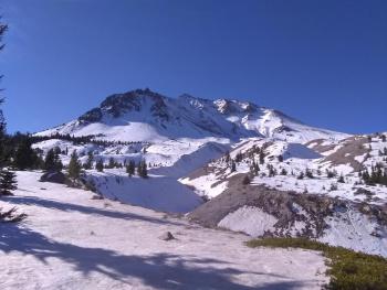
- A thin snowpack dominates the forecast area with many exposed rocks, trees and brushes.
- Up to 2 inches of new snow fell on Friday, adding to the 12 inches of snow remaining from November.
- Weak sugary faceted snow was found below fresh snow on colder, near and below treeline areas near Gray Butte.
- Temperatures have ranged from 17 to 35 °F at 8,000 feet.
- Winds have shifted from the East and Northeast to the South and Southwest. Winds have been light, averaging 10 mi/hr, gusting up to 37.
Weather and Current Conditions
Weather Summary
A strong winter storm will bring snow and windy conditions to the Mount Shasta area over the next 24 hours. A winter weather advisory is in effect from 4 a.m. to 10 p.m. Snow levels will be near 4,300 feet today and could drop as low as 3,900 feet tonight. Expect 3-7 inches of snow accompanied by strong to gale force southerly winds above treeline. The heaviest snowfall will occur this morning.
More weather fronts are expected through the remainder of the month. The next system is scheduled to arrive Wednesday.
24 Hour Weather Station Data @ 6:00 AM
| Weather Station | Temp (°F) | Wind (mi/hr) | Snow (in) | Comments | ||||||||
|---|---|---|---|---|---|---|---|---|---|---|---|---|
| Cur | Min | Max | Avg | Avg | Max Gust | Dir | Depth | New | Water Equivalent | Settlement | ||
| Mt. Shasta City (3540 ft) | 34 | 31 | 41 | 35.5 | 1 | N | ||||||
| Sand Flat (6750 ft) | 27 | 22 | 30 | 26 | 10 | 0 | 0 | 0 | ||||
| Ski Bowl (7600 ft) | 24.5 | 17 | 38 | 27 | 14.6 | 0 | 0 | 0 | ||||
| Gray Butte (8000 ft) | 22.5 | 17 | 35.5 | 25.5 | 10 | 37 | W | |||||
| Castle Lake (5870 ft) | 25.5 | 24 | 29.5 | 26.5 | 4.5 | 1.5 | 0 | |||||
| Mount Eddy (6509 ft) | 25.5 | 19.5 | 36.5 | 27.5 | 2 | 6 | WSW | 8 | 0 | 0 | ||
| Ash Creek Bowl (7250 ft) | 22.5 | 16 | 36 | 24 | 16 | 1.8 | 0.1 | |||||
| Ash Creek Ridge (7895 ft) | 19.5 | 13.5 | 33 | 23 | 0 | 0 | N |
Two Day Mountain Weather Forecast
Produced in partnership with the Medford NWS
| For 7000 ft to 9000 ft | |||
|---|---|---|---|
|
Sunday (4 a.m. to 10 p.m.) |
Sunday Night (10 p.m. to 4 a.m.) |
Monday (4 a.m. to 10 p.m.) |
|
| Weather | Breezy. Snow this morning, then snow showers this afternoon. Patchy blowing snow through the day. | Mostly cloudy. Snow showers in the evening, then a slight chance of snow showers after midnight. | Mostly cloudy with a slight chance of snow showers in the morning, then partly cloudy in the afternoon. |
| Temperature (°F) | 32 | 22 | 30 |
| Wind (mi/hr) | South 10-15 | West 5-10 | Northwest 5-10 |
| Precipitation SWE / Snowfall (in) | 0.46 / 3-7 | 0.02 / 1-2 | 0.00 / 0-0.50 |
| For 9000 ft to 11000 ft | |||
| Sunday | Sunday Night | Monday | |
| Weather | Snow, windy. Wind chill values as low as -11. | Mostly cloudy. Snow showers in the evening, then a slight chance of snow showers after midnight. Wind chill values as low as -12. | Mostly cloudy with a slight chance of snow showers in the morning, then partly cloudy in the afternoon. |
| Temperature (°F) | 23 | 12 | 16 |
| Wind (mi/hr) | Southwest 40-50 | West 30-35 | Northwest 15-25 |
| Precipitation SWE / Snowfall (in) | 0.46 / 3-7 | 0.02 / 1-2 | 0.00 / 0-0.50 |
Season Precipitation for Mount Shasta City
| Period | Measured (in) | Normal (in) | Percent of Normal (%) |
|---|---|---|---|
| From Oct 1, 2025 (the wet season) | 1.73 | 10.18 | 17 |
| Month to Date (since Jun 1, 2026) | 0.03 | 2.82 | 1 |
| Year to Date (since Jan 1, 2026) | 14.64 | 38.18 | 38 |

