

You are here
Avalanche Forecast for 2021-01-22 06:37
- EXPIRED ON January 23, 2021 @ 6:37 amPublished on January 22, 2021 @ 6:37 am
- Issued by Nick Meyers - Shasta-Trinity National Forest
Bottom Line
Avalanche activity remains unlikely. Widespread firm and icy conditions present hazards for backcountry users like long, sliding falls. A trace amount of new snow fell overnight and snow showers linger this morning. Low avalanche danger exists for all elevations and aspects. Travel using normal caution. Be willing to step back into safer terrain if conditions warrant.


Avalanche Problem 1: Normal Caution
-
Character ?

-
Aspect/Elevation ?
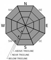
-
Likelihood ?CertainVery LikelyLikelyPossible
 Unlikely
 -
Size ?HistoricVery LargeLargeSmall

One will encounter exposed ground, rocks and icy slopes while on Mount Shasta. Other locations within the forecast area host barely usable snowpacks. While avalanche activity remains very unlikely, the firm conditions present hazards like uncontrollable, long, sliding falls. Slips and falls in these conditions never turns out well. Take it seriously. Watch for rockfall on the upper mountain and wear a helmet. Proper ice axe and crampon use is mandatory for climbers. The mountain looks as it usually does in late fall, when climbing conditions are the worst.
Forecast Discussion
 The Abominable Snowman says, "Grrr...get on over to the VIRTUAL SNOWBALL SITE!"
Recent Observations
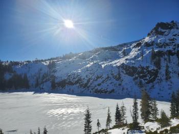
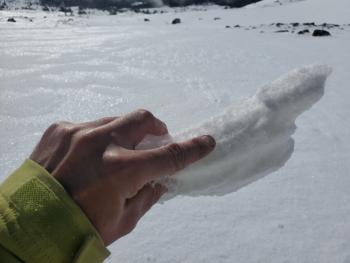
A quiet day on the mountain yesterday, for good reason. Snow surfaces struggled to soften, if at all. High clouds, cooling temperatures and light to moderate winds out of the W/NW was the soup de jour. As of this morning, a trace of new snow fell overnight (0.02 SWE). Existing snow surfaces are firm and icy on all aspects and elevations. We have not found any signs of instability. Check out the recent Casaval Ridge/upper mountain observation and photos HERE.

Weather and Current Conditions
Weather Summary
A low pressure center is moving south off the coast and will not progress any further inland. Cold air aloft will remain over the area today creating conditions conducive for convection. Shower activity will linger over higher terrain, diminishing this evening. Accumulation will be minimal. Snow levels will rise to 3,500 to 4,000 feet. A stronger front will move onshore Sunday brining lower snow levels and a couple inches of snow. A short break in the weather will ensue for the first part of next week. Beginning sometime Tuesday is when a real storm looks to arrive.
24 Hour Weather Station Data @ 5:00 AM
| Weather Station | Temp (°F) | Wind (mi/hr) | Snow (in) | Comments | ||||||||
|---|---|---|---|---|---|---|---|---|---|---|---|---|
| Cur | Min | Max | Avg | Avg | Max Gust | Dir | Depth | New | Water Equivalent | Settlement | ||
| Mt. Shasta City (3540 ft) | 34 | 30 | 50 | 39 | 1 | N | ||||||
| Sand Flat (6750 ft) | 24 | 24 | 37 | 31 | n/a | 0 | 0 | 0 | snow depth sensor broken | |||
| Ski Bowl (7600 ft) | 19 | 19 | 35 | 28 | 38.8 | 0 | 0.02 | 0 | ||||
| Gray Butte (8000 ft) | 18 | 18 | 34 | 26 | 9 | 25 | WNW | |||||
| Castle Lake (5870 ft) | 25 | 25 | 43 | 33 | 6 | 0 | 0 | |||||
| Mount Eddy (6509 ft) | 23 | 23 | 42 | 31 | 1 | 4 | SSW | 11.6 | 0 | 0 | ||
| Ash Creek Bowl (7250 ft) | 21 | 21 | 37.5 | 28.5 | 32.4 | 0 | 0.1 | |||||
| Ash Creek Ridge (7895 ft) | 17.5 | 17.5 | 35 | 25.5 | 11 | 38 | S |
Two Day Mountain Weather Forecast
Produced in partnership with the Medford NWS
| For 7000 ft to 9000 ft | |||
|---|---|---|---|
|
Friday (4 a.m. to 10 p.m.) |
Friday Night (10 p.m. to 4 a.m.) |
Saturday (4 a.m. to 10 p.m.) |
|
| Weather | Mostly cloudy with a 30% chance of snow showers. Snow level near 3 to 4,000 feet. | Mostly cloudy with a slight chance of snow in the evening, becoming partly cloudy. Snow level near 3 to 4,000 feet. | Partly cloudy in the morning, becoming sunny. |
| Temperature (°F) | 29 | 22 | 33 |
| Wind (mi/hr) | North/Northwest 0-10 | North 0-10 | North 0-10 |
| Precipitation SWE / Snowfall (in) | 0.08 / 1-1 | 0.00 / 0-1 | 0.00 / 0 |
| For 9000 ft to 11000 ft | |||
| Friday | Friday Night | Saturday | |
| Weather | Mostly cloudy, chance of snow showers | Mostly cloudy, windy. | Sunny |
| Temperature (°F) | 11 | 10 | 17 |
| Wind (mi/hr) | Northwest 5-15 | North 20-30 | Northeast 5-15 |
| Precipitation SWE / Snowfall (in) | 0.08 / 1-2 | 0.00 / 0-0.50 | 0.00 / 0 |
Season Precipitation for Mount Shasta City
| Period | Measured (in) | Normal (in) | Percent of Normal (%) |
|---|---|---|---|
| From Oct 1, 2025 (the wet season) | 5.75 | 20.13 | 29 |
| Month to Date (since Jun 1, 2026) | 2.17 | 4.92 | 44 |
| Year to Date (since Jan 1, 2026) | 2.17 | 4.92 | 44 |

