

You are here
Avalanche Forecast for 2021-01-23 06:25
- EXPIRED ON January 24, 2021 @ 6:25 amPublished on January 23, 2021 @ 6:25 am
- Issued by Nick Meyers - Shasta-Trinity National Forest
Bottom Line
Mount Shasta received 1 inch of new snow over the past 24 hours. Today will be mostly sunny with north wind. Significant avalanche activity remains unlikely today, but conditions will begin to change as new snow and wind start to form small snowdrifts near ridgelines. Firm and icy snow surfaces still dominate with many areas scoured to rock. Long, sliding falls are possible on steeper terrain. Watch for rockfall on the upper mountain.


Avalanche Problem 1: Normal Caution
-
Character ?

-
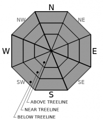
Aspect/Elevation ?
-
Likelihood ?CertainVery LikelyLikelyPossible
 Unlikely
 -
Size ?HistoricVery LargeLargeSmall

An inch of new snow will cover crusts with a layer of soft snow creating the classic dust on crust conditions. Still, expect firm and icy surfaces due to cloud cover and cool temperatures. The one inch of new snow and northerly wind may form small snowdrifts near ridge lines on leeward southerly aspects. Since we only received a touch of new snow, wind slab formation should remain minimal. More problematic wind slabs could form on wind-loaded slopes tomorrow if storm totals reach the higher end of forecasted amounts.
Avalanche activity remains unlikely today, but other hazards exist including rockfall and uncontrollable, long, sliding falls on icy slopes. Conditions will begin to change tomorrow as new snow and wind impact the forecast area. Monitor the snowpack while you travel. Be willing to step back into safer terrain if conditions exceed your group's comfort level. Even though the avalanche danger is low, stay alert and pay attention to signs of instability and changing conditions.
Forecast Discussion
It's the second to last day of the VIRTUAL SNOWBALL event. The typical in person party is our largest fundraiser of the year. The party is up to you this season, and so is the bidding! We've still got the silent auction and raffle going on (read: awesome stuff) via our VIRTUAL PLATFORM...SO GET ON IN HERE!
Recent Observations
Another quiet day on the hill with snow flurries throughout the day.
- New snow accumulation on mountain: ~1 inch [2.5 cm] / 0.11 SWE (Trace amounts on the west side)
- Wind: Variable 0-5 mph - Gusts 31 mph E/SE
- Temperature at treeline: Min 15 F - Max 23 F - Avg 19 F
- Total height of snow: Mount Shasta - 40 inches [101.5 cm] / Castle Lake: 6 inches [15 cm] / Mt. Eddy: 11.5 inches [29 cm]
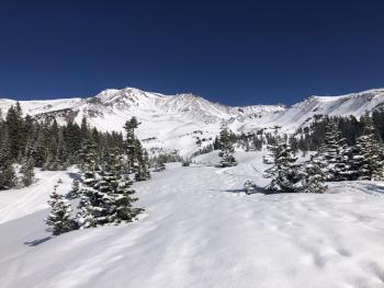
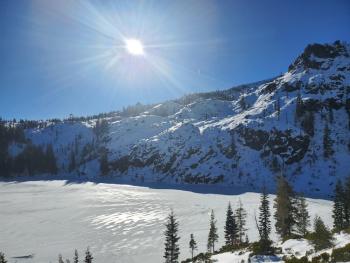
- Firm and icy conditions with a little "dust on crust". Snow coverage is very thin and scoured to mostly rock along wind exposed terrain. Gullies have the best coverage, but still expect rocks. Old tracks, breakable crust and overall dicey skiing and riding conditions are widespread.
- Zero signs of avalanche danger
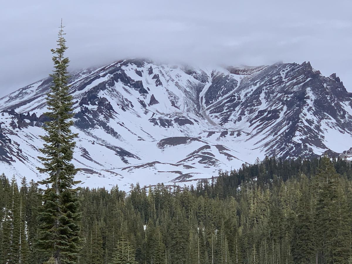
South side of Mount Shasta yesterday 1.23.21 from Bunny Flat, Avalanche Gulch center.

Weather and Current Conditions
Weather Summary
A little break in the action today, if you'd call yesterday action at all. Expect mostly clear skies for this fine Saturday with that pesky north wind on the mountain. Temperatures are cool, in the teens above treeline and near freezing below treeline (7,000 feet). Most attention is looking forward into Sunday and next week. A couple inches of lower elevation snow is expected Sunday. A stronger, cold low pressure system will likely bring heavy snow across Siskiyou County, Tuesday into Wednesday, especially the Mount Shasta area.
24 Hour Weather Station Data @ 5:00 AM
| Weather Station | Temp (°F) | Wind (mi/hr) | Snow (in) | Comments | ||||||||
|---|---|---|---|---|---|---|---|---|---|---|---|---|
| Cur | Min | Max | Avg | Avg | Max Gust | Dir | Depth | New | Water Equivalent | Settlement | ||
| Mt. Shasta City (3540 ft) | 34 | 30 | 50 | 39 | 1 | N | ||||||
| Sand Flat (6750 ft) | 22 | 17 | 26 | 23 | 0 | 0 | 0 | 0 | snow depth sensor broken | |||
| Ski Bowl (7600 ft) | 16.5 | 15 | 23 | 19 | 39.7 | 0.8 | 0.11 | 0 | ||||
| Gray Butte (8000 ft) | 16.5 | 16.5 | 20 | 18.5 | 5 | 31 | ESE | |||||
| Castle Lake (5870 ft) | 23.5 | 23.5 | 28.5 | 25.5 | 6 | 0 | 0 | |||||
| Mount Eddy (6509 ft) | 21.5 | 21.5 | 26 | 23.5 | 1 | 5 | SSE | 11.6 | 0 | 0 | ||
| Ash Creek Bowl (7250 ft) | 20 | 20 | 23 | 21.5 | 33.2 | 0.8 | 0 | |||||
| Ash Creek Ridge (7895 ft) | 16.5 | 16.5 | 20.5 | 18 | 4 | 23 | WNW |
Two Day Mountain Weather Forecast
Produced in partnership with the Medford NWS
| For 7000 ft to 9000 ft | |||
|---|---|---|---|
|
Saturday (4 a.m. to 10 p.m.) |
Saturday Night (10 p.m. to 4 a.m.) |
Sunday (4 a.m. to 10 p.m.) |
|
| Weather | Partly sunny | Increasing clouds | Snow, snow level 2,000 to 3,000 feet. |
| Temperature (°F) | 31 | 22 | 28 |
| Wind (mi/hr) | North 0-10 | North/Northwest 0-10 | Southwest 0-10 |
| Precipitation SWE / Snowfall (in) | 0.00 / 1-1 | 0.00 / 0-1 | 0.32 / 2-4 |
| For 9000 ft to 11000 ft | |||
| Saturday | Saturday Night | Sunday | |
| Weather | Mostly sunny, windy. | Increasing clouds, blustery. | Snow after 10 a.m. Blustery. |
| Temperature (°F) | 17 | 15 | 15 |
| Wind (mi/hr) | North 20-30 | North 10-20 | West 10-20 |
| Precipitation SWE / Snowfall (in) | 0.00 / 0 | 0.00 / 0 | 0.32 / 3-5 |
Season Precipitation for Mount Shasta City
| Period | Measured (in) | Normal (in) | Percent of Normal (%) |
|---|---|---|---|
| From Oct 1, 2025 (the wet season) | 5.77 | 20.35 | 28 |
| Month to Date (since Jun 1, 2026) | 2.19 | 5.14 | 43 |
| Year to Date (since Jan 1, 2026) | 2.19 | 5.14 | 43 |

