

You are here
Avalanche Forecast for 2021-01-24 06:30
- EXPIRED ON January 25, 2021 @ 6:30 amPublished on January 24, 2021 @ 6:30 am
- Issued by Ryan Sorenson - Mount Shasta Avalanche Center
Bottom Line
A cold front will bring fresh snow and light to moderate northwesterly winds to the mountains over the next 24 hours. Snow levels will be near 2,000 to 3,000 feet. Expect the total snow accumulation to be 2 to 5 inches. Watch for fresh wind slab avalanches on isolated steep leeward slopes that previously held a snowpack.
Join us tonight for the final, hilarious, ridiculous, improvisational ending to the Virtual Snowball. You won't be dissapointed.


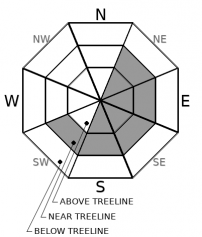
Avalanche Problem 1: Wind Slab
-
Character ?

-
Aspect/Elevation ?
-
Likelihood ?CertainVery LikelyLikelyPossible
 Unlikely
 -
Size ?HistoricVery LargeLargeSmall

Cold fresh snow will gradually add to the dust on crust conditions. Snow accumulation up to 5 inches is possible above treeline. Expect light to moderate northwesterly winds. Watch for fresh wind slab development on NE-E-SE-S-SW aspects near and above treeline. Wind slabs are expected to remain small and isolated to steep leeward slopes that previously held a snowpack. The snow coverage is thin above treeline and scoured to rock in many of the typical avalanche starting zones on the south side of Mount Shasta.
Natural and human triggered avalanche activity remains unlikely. However, continue to watch for isolated wind slabs on steep leeward slopes. Steep areas that previously hosted a snowpack are most suspect. Stay mindful and monitor the snowpack while you travel. Ask yourself where wind slabs might be forming. Be willing to step back into safer terrain if you experience cracking and blocking within the snowpack. Adjust travel plans to minimize exposure to wind slabs on steep slopes.
Forecast Discussion

Yep, you don't even have to finish shoveling your driveway. Sit back and enjoy the bidding as the snowfalls. The silent auction and raffle action continues all day (read: awesome stuff) via our VIRTUAL PLATFORM. Make sure to check back in at 5 p.m. where live from the FMSAC zoom studio we bring you the Livestream Giveaway and Snow Ball Telethon Extravaganza! ZOOM link - CLICK HERE
Recent Observations
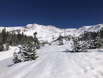
A dusting of fresh snow (received on 01.22.2020) two inches deep sits over a beat-up, icy and well-consolidated snowpack. Minimal wind effects were observed on a tour in Avalanche Gulch. Smooth surface snow textures. The dusting only partially covered the old tracks and breakable crusts. Overall dicey skiing and riding conditions continue. Snow coverage is thin and scoured to mostly rock along wind exposed terrain. Gullies have the best coverage. Expect rocks and other buried obstacles everywhere. The fresh snow is making many obstacles unlikely to see and easier to hit. No obvious signs of avalanche danger were observed.
In the past 24 hours:
- Wind: Variable 5-10 mph - Gusts 31 mph. Predominate wind direction, ESE switching to WNW.
- Temperature at treeline: Min 15 F - Max 31.5 F - Avg 22.5 F
- Total height of snow: Mount Shasta - 40 inches [101.5 cm] / Castle Lake: 6 inches [15 cm] / Mt. Eddy: 11.5 inches [29 cm] / Ash Creek Bowl: 33 inches [84 cm]

Weather and Current Conditions
Weather Summary
A quick-moving cold front is set to bring 2 to 5 inches of snow over the next 24 hours. Overcast skies will begin to snow around 9 a.m. with snow levels falling as low as 2,000 feet. Temperatures are cool, in the teens above treeline and mid 20's F below treeline (7,000 feet). Temperatures above treeline will fall into the single digits tonight as the storm passes. Expect gradually clearing skies tomorrow. Winds primarily out of the west/southwest will be light to moderate.
A stronger, cold low-pressure system will likely bring heavy snow across Siskiyou County, Tuesday into Wednesday, especially the Mount Shasta area.
24 Hour Weather Station Data @ 4:00 AM
| Weather Station | Temp (°F) | Wind (mi/hr) | Snow (in) | Comments | ||||||||
|---|---|---|---|---|---|---|---|---|---|---|---|---|
| Cur | Min | Max | Avg | Avg | Max Gust | Dir | Depth | New | Water Equivalent | Settlement | ||
| Mt. Shasta City (3540 ft) | 21 | 21 | 43 | 32 | 3 | N | ||||||
| Sand Flat (6750 ft) | 15 | 14 | 30 | 22 | 0 | 0 | 0 | 0 | snow depth sensor broken | |||
| Ski Bowl (7600 ft) | 20 | 15 | 31.5 | 22.5 | 39.3 | 0 | 0 | 0.1 | ||||
| Gray Butte (8000 ft) | 22 | 16.5 | 27 | 22.5 | 7 | 31 | ESE | |||||
| Castle Lake (5870 ft) | 27.5 | 22.5 | 28.5 | 25.5 | 6 | 0 | 0 | |||||
| Mount Eddy (6509 ft) | 22 | 20 | 29 | 24.5 | 2 | 6 | WSW | 11.6 | 0 | 0 | ||
| Ash Creek Bowl (7250 ft) | 19.5 | 15.5 | 23.5 | 19.5 | 33.1 | 0 | 0.2 | |||||
| Ash Creek Ridge (7895 ft) | 21.5 | 14 | 22.5 | 18 | 5 | 17 | NW |
Two Day Mountain Weather Forecast
Produced in partnership with the Medford NWS
| For 7000 ft to 9000 ft | |||
|---|---|---|---|
|
Sunday (4 a.m. to 10 p.m.) |
Sunday Night (10 p.m. to 4 a.m.) |
Monday (4 a.m. to 10 p.m.) |
|
| Weather | Snow. Snow level 2,000 to 3,000 feet. | Chance of snow showers in the evening, then a slight chance of snow showers after midnight. Snow level 2,000 to 3,000 feet. | Mostly cloudy in the morning then becoming partly cloudy. |
| Temperature (°F) | 30 | 16 | 26 |
| Wind (mi/hr) | Southwest 0-10 | North/Northwest 10-15 | North/Northwest 5-10 |
| Precipitation SWE / Snowfall (in) | 0.26 / 1-3 | 0.08 / 0-1 | 0.00 / 0 |
| For 9000 ft to 11000 ft | |||
| Sunday | Sunday Night | Monday | |
| Weather | Snow, windy. Blowing snow. | Chance of snow showers in the evening, then a slight chance of snow showers after midnight. | Mostly cloudy in the morning then becoming partly cloudy. |
| Temperature (°F) | 19 | 5 | 6 |
| Wind (mi/hr) | West 15-20 | North/Northwest 20-25 | North/Northwest 15-20 |
| Precipitation SWE / Snowfall (in) | 0.26 / 2-4 | 0.08 / 0-1 | 0.00 / 0 |
Season Precipitation for Mount Shasta City
| Period | Measured (in) | Normal (in) | Percent of Normal (%) |
|---|---|---|---|
| From Oct 1, 2025 (the wet season) | 5.77 | 20.57 | 28 |
| Month to Date (since Jun 1, 2026) | 2.19 | 5.36 | 41 |
| Year to Date (since Jan 1, 2026) | 2.19 | 5.36 | 41 |

