

You are here
Avalanche Forecast for 2021-01-25 06:30
- EXPIRED ON January 26, 2021 @ 6:30 amPublished on January 25, 2021 @ 6:30 am
- Issued by Ryan Sorenson - Mount Shasta Avalanche Center
Bottom Line
Yesterday's storm is breaking and leaving lingering showers and light northerly winds. The measured snow accumulation near treeline on Mount Shasta is 8 inches. Snow levels were as low as 2,000 feet. Natural and human triggered avalanche activity remains unlikely. Watch for isolated wind slab development on loaded NE-E-SE-S-SW aspects. Steep areas that previously hosted a snowpack are most suspect.


Avalanche Problem 1: Wind Slab
-
Character ?

-
Aspect/Elevation ?
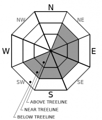
-
Likelihood ?CertainVery LikelyLikelyPossible
 Unlikely
 -
Size ?HistoricVery LargeLargeSmall

A cold front yesterday brought 8 inches (0.33 SWE) of fresh snow with low snow levels. Expected winds are light, primarily out of the northwest. Watch for fresh wind slab development on NE-E-SE-S-SW aspects near and above treeline. Clearing skies and calming winds should keep wind slabs small and isolated to steep leeward slopes that previously held a snowpack. Steep slopes near treeline are most suspect. The previous snow coverage was thin above treeline and scoured to rock in many of the typical avalanche starting zones on the south side of Mount Shasta. Anticipate changing conditions as more snow arrives tomorrow.
LOW avalanche danger does not mean NO danger. Stay mindful and monitor the snowpack while you travel. Ask yourself where wind slabs might be forming. Be willing to step back into safer terrain if you experience cracking and blocking within the snowpack. Adjust travel plans to minimize exposure to wind slabs on steep slopes.
Forecast Discussion
Thank you to everyone who supported us during our Virtual Snowball last night! What a wonderful event. We were able to raise $16,295! We can't express the love and gratitude we feel for the community and sponsors' support enough. Thank you!
Recent Observations
A dusting of fresh snow remained over the beat-up, icy and well-consolidated snowpack in Old Ski Bowl yesterday morning. It was beginning to snow and up to an inch of fresh had accumulated by 11 a.m. Snowfall continued throughout the day leaving 6 inches in town as we were finishing up the snowball at 7 p.m.
In the past 24 hours:
- New snow accumulation on mountain: 8 inches [20 cm] / 0.35 SWE
- Wind: Decreasing winds 10-15 mph before 6 p.m. 0-5 mph after 6 p.m. Predominate wind direction, WNW switching to ESE.
- Wind gusts as high as 31 mph.
- Temperature at treeline: Min 12 F - Max 24 F - Avg 16.5 F
- Total height of snow: Mount Shasta - 47.5 inches [120.5 cm] / Ash Creek Bowl: 39 inches [99 cm]
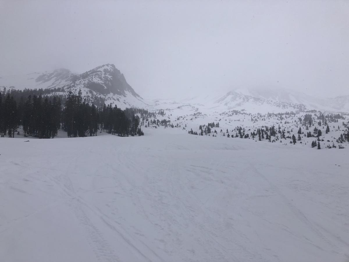
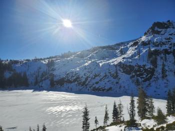
South side of Mount Shasta yesterday 11 a.m. 1.24.21 from Old Ski Bowl.

Weather and Current Conditions
Weather Summary
Lingering snow showers are possible this morning, then a brief break in the precipitation department. The temperature will remain cool, in the upper teens to low 20's F below treeline and single digits for upper elevations. Snow levels will remain near 2,000 feet. Expect gradually clearing skies. Light winds will be out of the north.
You asked, and the snow gods answered. A Winter Storm Warning is in effect from January 26, 01:00 p.m. until January 27, 04:00 a.m. Models are now confident that a potent low-pressure system will swing south, mixing with cold air and bring heavy snowfall across Siskiyou County, starting tomorrow and continuing into Wednesday. Expect 21 to 32 inches of total snow accumulation as 2.79 inches of precipitable water plays out with snow levels near 2,000 feet for Tuesday and Wednesday. Snow showers are expected to continue throughout the week.
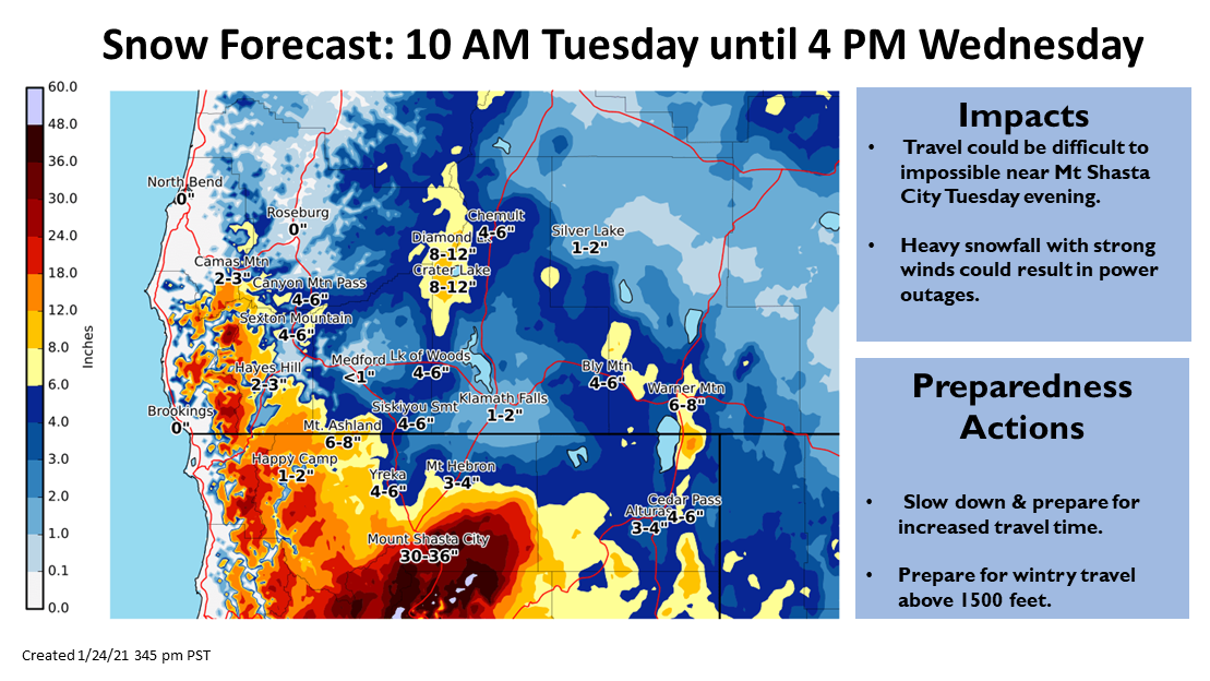
Snow forecast created by the NWS forecast office in Medford, OR.
24 Hour Weather Station Data @ 6:00 AM
| Weather Station | Temp (°F) | Wind (mi/hr) | Snow (in) | Comments | ||||||||
|---|---|---|---|---|---|---|---|---|---|---|---|---|
| Cur | Min | Max | Avg | Avg | Max Gust | Dir | Depth | New | Water Equivalent | Settlement | ||
| Mt. Shasta City (3540 ft) | 21 | 21 | 43 | 32 | 3 | N | ||||||
| Sand Flat (6750 ft) | 15 | 15 | 24 | 20 | 0 | 0 | 0 | 0 | snow depth sensor broken | |||
| Ski Bowl (7600 ft) | 11.5 | 11.5 | 21 | 17 | 47.3 | 7.7 | 0.35 | 0 | ||||
| Gray Butte (8000 ft) | 11 | 11 | 23.5 | 16 | 7 | 31 | WNW | |||||
| Castle Lake (5870 ft) | 15.5 | 15.5 | 31.5 | 23.5 | 6 | 0 | 0 | snow depth sensor broken | ||||
| Mount Eddy (6509 ft) | 13 | 13 | 27 | 20.5 | 2 | 7 | SE | 11.6 | 0 | 0 | ||
| Ash Creek Bowl (7250 ft) | 10.5 | 10.5 | 25 | 18 | 38.8 | 5.9 | 0 | |||||
| Ash Creek Ridge (7895 ft) | 6.5 | 6.5 | 22 | 14.5 | 8 | 25 | WNW |
Two Day Mountain Weather Forecast
Produced in partnership with the Medford NWS
| For 7000 ft to 9000 ft | |||
|---|---|---|---|
|
Monday (4 a.m. to 10 p.m.) |
Monday Night (10 p.m. to 4 a.m.) |
Tuesday (4 a.m. to 10 p.m.) |
|
| Weather | Mostly cloudy in the morning then becoming partly cloudy. A 20% chance of snow showers. | Mostly clear. Cold temperatures. | Windy. Partly cloudy with snow likely in the morning, then mostly cloudy with heavy snow in the afternoon and evening. |
| Temperature (°F) | 23 | 12 | 22 |
| Wind (mi/hr) | North/Northwest 5-10 | North/Northwest 5-10 | South 5-10 |
| Precipitation SWE / Snowfall (in) | 0.00 / 0-1 | 0.00 / 0 | 0.71 / 6-12 |
| For 9000 ft to 11000 ft | |||
| Monday | Monday Night | Tuesday | |
| Weather | Mostly cloudy in the morning then becoming partly cloudy. A 20% chance of snow showers. | Mostly clear. Blustery. Wind chill values as low as -21. | Windy. Partly cloudy with snow likely in the morning, then mostly cloudy with heavy snow in the afternoon and evening. |
| Temperature (°F) | 6 | 5 | 14 |
| Wind (mi/hr) | North 15-20 | North 10-15 | Southwest 25-30 |
| Precipitation SWE / Snowfall (in) | 0.00 / 0-1 | 0.00 / 0 | 0.71 / 8-13 |
Season Precipitation for Mount Shasta City
| Period | Measured (in) | Normal (in) | Percent of Normal (%) |
|---|---|---|---|
| From Oct 1, 2025 (the wet season) | 6.19 | 20.79 | 30 |
| Month to Date (since Jun 1, 2026) | 2.61 | 5.58 | 47 |
| Year to Date (since Jan 1, 2026) | 2.61 | 5.58 | 47 |

