

You are here
Avalanche Forecast for 2021-01-28 06:01
- EXPIRED ON January 29, 2021 @ 6:01 amPublished on January 28, 2021 @ 6:01 am
- Issued by Nick Meyers - Shasta-Trinity National Forest
Bottom Line
Avalanche danger is HIGH for all elevations and aspects. The recent storm that began on Tuesday afternoon delivered non-stop, high-flying snow action for nearly 38 hours straight, and more is expected today. Mix in moderate to strong southerly wind, and you've got a good mix for large and consequential avalanches. Travel in avalanche terrain is not recommended.


Avalanche Problem 1: Wind Slab
-
Character ?

-
Aspect/Elevation ?
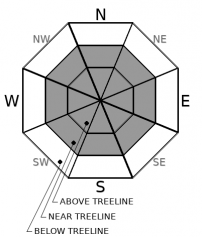
-
Likelihood ?CertainVery LikelyLikelyPossible
 Unlikely
 -
Size ?HistoricVery LargeLargeSmall

South. That is the primary direction the wind has blown from for the duration of this week's storm. Multiple feet of new snow and gale force winds have likely created large wind slabs on northerly facing slopes, near and above treeline. Cornices are also large and weak. It's unknown how sensitive these slabs/cornices will be to trigger. Any terrain below large cornices or wind loaded slopes is suspect.
Avalanche Problem 2: Storm Slab
-
Character ?

-
Aspect/Elevation ?
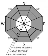
-
Likelihood ?CertainVery LikelyLikelyPossible
Unlikely
-
Size ?HistoricVery LargeLargeSmall
Storm slab avalanches could occur on all aspects near and below treeline. With an additional 5-10 inches forecast today, continue to be cautious. Rapid loading, temperature fluctuations and slight changes in wind could cause storm slab avalanches. Yesterday afternoon, slab properties were very good due to a slight increase in temperature. Slab avalanches could involve part of or all of the recent storm snow.
Forecast Discussion
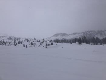
It's often that our snowpack settles out quickly, and we typically don't see lingering instabilities... don't let this notion be your ticket to ride. Another bout of snow is expected today and southerly wind will continue to push snow around. The biggest at risk users will be snowmobiles and Gray Butte backcountry skiers via Ski Park. Take a step back if you make it into the backcountry, proceed with extreme caution. The snow is deep and any avalanche could be large. Be cautious of tree wells...they are like the venus fly traps of winter. The Everitt and Castle lake roads are still closed, and it's unknown when they will open.
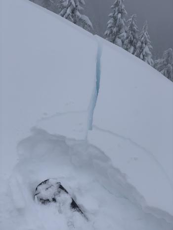
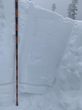
Recent Observations
Our strategic mindset is still in the assessment phase after the substantial weather event that started Tuesday afternoon. Road and backcountry ski travel was difficult yesterday due to deep snow. Visibility was obscured all day. Here is what we've observed thus far since the storm began on January 26th at 1400 hours:
- Total storm snow measured at treeline on Mount Shasta, as of this morning at 0500: 27 inches / 2.28 SWE (Snow-Water Equivalent)
- Wind speed min / max / average (mph): 1 / 49 / 9
- Temperature min / max / average (°F): 7 / 21 / 14
A tour around and to the top of Coyote Butte, Mt. Shasta Ski Park yesterday yielded extremely arduous backcountry travel conditions. New snow measured at Old Ski Bowl is 27 inches, but upwards of 3 feet was measured in some areas. Wind drifts were observed 3 to 4 feet deep. Numerous signs of avalanche danger presented including widespread wind blowing snow, heavy snowfall, shooting cracks and whoomphing in the snowpack.
Weather and Current Conditions
Weather Summary
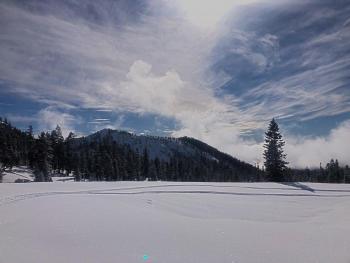
We've entered into the last 24 hours of the long duration, high impact snow event that began on Tuesday. The atmospheric forces that have driven this event are toned down today and tonight compared to the past 48 hours. A winter storm warning remains in effect until 4 p.m. PST this afternoon. Additional snow accumulation of 4-8 inches is expected at lower elevations and locally up to a foot above 5,000 feet. Winds will gust as high as 45 mi/hr over exposed terrain. We should get a break in the action on Friday, giving everyone time to fix broken equipment, dig out and catch a breath. Then, another major trough will try to make a repeat snow storm event, Sunday into Monday.
24 Hour Weather Station Data @ 5:00 AM
| Weather Station | Temp (°F) | Wind (mi/hr) | Snow (in) | Comments | ||||||||
|---|---|---|---|---|---|---|---|---|---|---|---|---|
| Cur | Min | Max | Avg | Avg | Max Gust | Dir | Depth | New | Water Equivalent | Settlement | ||
| Mt. Shasta City (3540 ft) | 32 | 27 | 34 | 31.5 | 2 | N | ||||||
| Sand Flat (6750 ft) | 24 | 17 | 25 | 23 | 0 | 0 | 0 | snow sensor broken | ||||
| Ski Bowl (7600 ft) | 21 | 13 | 21 | 19 | 73.7 | 6.8 | 1.17 | 0 | ||||
| Gray Butte (8000 ft) | 20 | 12 | 20 | 17.5 | 12 | 43 | SSE | |||||
| Castle Lake (5870 ft) | 24.5 | 18 | 25 | 23.5 | 49.3 | 7 | 0 | |||||
| Mount Eddy (6509 ft) | 23.5 | 17 | 23.5 | 22 | 2 | 6 | SW | 60.9 | 4.2 | 0 | ||
| Ash Creek Bowl (7250 ft) | 22 | 14.5 | 22 | 19.5 | 52.9 | 7.5 | 0 | |||||
| Ash Creek Ridge (7895 ft) | 19 | 11.5 | 19 | 16.5 | wind sensor now rimed |
Two Day Mountain Weather Forecast
Produced in partnership with the Medford NWS
| For 7000 ft to 9000 ft | |||
|---|---|---|---|
|
Thursday (4 a.m. to 10 p.m.) |
Thursday Night (10 p.m. to 4 a.m.) |
Friday (4 a.m. to 10 p.m.) |
|
| Weather | Snow showers, tapering off by 4 p.m. Windy. | Mostly cloudy with lingering snow showers. | Partly cloudy |
| Temperature (°F) | 26 | 19 | 28 |
| Wind (mi/hr) | South 5-10 | South 5-10 | Southwest 5-10 |
| Precipitation SWE / Snowfall (in) | 0.54 / 5-10 | 0.02 / 1-3 | 0.00 / 0 |
| For 9000 ft to 11000 ft | |||
| Thursday | Thursday Night | Friday | |
| Weather | Snow showers, mainly before 4 p.m. Snow heavy at times, windy. | Mostly cloudy, windy. | Partly sunny |
| Temperature (°F) | 33 | 22 | 10 |
| Wind (mi/hr) | South 30-40 | South 20-30 | Southwest 5-15 |
| Precipitation SWE / Snowfall (in) | 0.54 / 8-12 | 0.02 / 1-3 | 0.00 / 0 |
Season Precipitation for Mount Shasta City
| Period | Measured (in) | Normal (in) | Percent of Normal (%) |
|---|---|---|---|
| From Oct 1, 2025 (the wet season) | 9.18 | 21.43 | 43 |
| Month to Date (since Jun 1, 2026) | 5.60 | 6.22 | 90 |
| Year to Date (since Jan 1, 2026) | 5.60 | 6.22 | 90 |

