

You are here
Avalanche Forecast for 2021-03-06 06:26
- EXPIRED ON March 7, 2021 @ 6:26 amPublished on March 6, 2021 @ 6:26 am
- Issued by Nick Meyers - Shasta-Trinity National Forest
Bottom Line
Overnight, 4-6 inches of new snow blanketed the mountains of southern Siskiyou County and accompanied by a southerly wind. Fresh wind slabs are possible near and above treeline. Uncertainty exists in regard to the size, distribution and sensitivity to trigger of wind slabs. Evaluate the snow carefully as you enter avalanche terrain. Lingering showers this morning will give way to partly cloudy skies. Be mindful of shallow buried rocks.


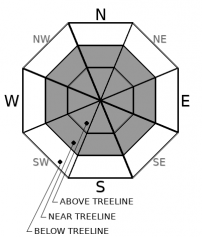
Avalanche Problem 1: Wind Slab
-
Character ?

-
Aspect/Elevation ?
-
Likelihood ?CertainVery LikelyLikelyPossible
 Unlikely
 -
Size ?HistoricVery LargeLargeSmall

Snow began to fall this morning at 0100 hours with about 4-6 inches observed via weather stations at 0600 hours. South/southeast winds may have loaded northerly facing slopes. Westerly wind is forecast for today. Existing snow surfaces are firm and variable. Look for wind deposits on the leeward side of near and above treeline terrain on prominent features such as ridges, peaks, bowls and passes. Wind can also blow across a slope and "cross-load". Wind can even cause loading when it blows down a slope. Remember, wind can blow from any direction on Mt. Shasta and deposit snow on most slopes. Be suspicious of any steep slope with recent deposits of wind drifted snow.
Identify wind slabs by looking for smooth, rounded, lens shaped, pillow shaped, chalky-white snow. They can feel "slabby" i.e. harder snow on top of softer snow and often sound hollow or drum-like. You may notice shooting cracks. Use small, inconsequential tests slopes to see how the snow responds. If a slab breaks away easily on your tests, don't cross larger slopes. Go back the way you came or find another route that avoids wind slabs.
Recent Observations
Yesterday was clear and windy for the daylight hours. Precipitation did not begin until the wee hours of the morning. Snow totals from around the area overnight:
- Old Ski Bowl - 3.5 inches / Temp (Low - High): 24° - 34° F
- Castle Lake - 5 inches / 33°- 43° F
- Eddy Mountains - 6 inches / 21.5° - 35.5°
- East Side (Ash Creek Butte) - 5 inches / 19.5° - 35°
Prior to the storm, the area has not seen any snow/rain since February 20th. Snow surfaces varied widely from soft to firm, satrugis, crusts, icy and wind affected. Many large patches of bare ground/rock are exposed on Mt. Shasta. The snow is dirty and has been pounded by southerly wind. Winds on Gray Butte, near treeline, averaged 10 mi/hr with gusts to 43 mi/hr, south/southeast.
Weather and Current Conditions
Weather Summary
The disturbance that brought a nice dollop of snow overnight is now moving to the east. The NWS winter weather advisory will expire this morning. Snow will diminish with a few isolated showers lingering into the AM hours. Partly cloudy to sunny skies will prevail for the remainder of the weekend. After this little break, another system will move in late Sunday/Monday bringing additional snow and wind through Tuesday. Later next week, chances of precipitation dwindle as the low drops south over southern and central California.
24 Hour Weather Station Data @ 4:00 AM
| Weather Station | Temp (°F) | Wind (mi/hr) | Snow (in) | Comments | ||||||||
|---|---|---|---|---|---|---|---|---|---|---|---|---|
| Cur | Min | Max | Avg | Avg | Max Gust | Dir | Depth | New | Water Equivalent | Settlement | ||
| Mt. Shasta City (3540 ft) | 33 | 33 | 54 | 40 | 5 | |||||||
| Sand Flat (6750 ft) | 24 | 24 | 38 | 32 | Snow sensor down | |||||||
| Ski Bowl (7600 ft) | 26 | 24 | 34 | 27.5 | 70.6 | 3.5 | n/a | 0 | ||||
| Gray Butte (8000 ft) | 22 | 22 | 31 | 25.5 | 11 | 37 | SSE | |||||
| Castle Lake (5870 ft) | 23.5 | 23.5 | 43 | 33 | 64.4 | 4.9 | 0 | |||||
| Mount Eddy (6509 ft) | 21.5 | 21.5 | 35.5 | 30 | 3 | 9 | SW | 63 | 6 | 0 | ||
| Ash Creek Bowl (7250 ft) | 19.5 | 19.5 | 35 | 27.5 | 59.2 | 4.4 | 0 | |||||
| Ash Creek Ridge (7895 ft) | 16 | 16 | 29 | 23.5 | 16 | 58 | S |
Two Day Mountain Weather Forecast
Produced in partnership with the Medford NWS
| For 7000 ft to 9000 ft | |||
|---|---|---|---|
|
Saturday (4 a.m. to 10 p.m.) |
Saturday Night (10 p.m. to 4 a.m.) |
Sunday (4 a.m. to 10 p.m.) |
|
| Weather | Chance of snow this morning, then partly cloudy this afternoon. Snow level near 3,800 feet. | Partly cloudy. | Partly cloudy |
| Temperature (°F) | 29 | 19 | 31 |
| Wind (mi/hr) | West 0-5 | Southwest 5-10 | West 0-5 |
| Precipitation SWE / Snowfall (in) | 0.03 / 0-0.50 | 0.00 / 0 | 0.00 / 0 |
| For 9000 ft to 11000 ft | |||
| Saturday | Saturday Night | Sunday | |
| Weather | Snow likely before 10am, becoming mostly sunny in afternoon, breezy. | Partly cloudy, windy. | Partly cloudy. |
| Temperature (°F) | 20 | 16 | 15 |
| Wind (mi/hr) | West 10-20 | Southwest 20-30 | West 15-25 |
| Precipitation SWE / Snowfall (in) | 0.03 / 0-1 | 0.00 / 0 | 0.00 / 0 |
Season Precipitation for Mount Shasta City
| Period | Measured (in) | Normal (in) | Percent of Normal (%) |
|---|---|---|---|
| From Oct 1, 2025 (the wet season) | 13.60 | 30.77 | 44 |
| Month to Date (since Jun 1, 2026) | 0.02 | 1.27 | 2 |
| Year to Date (since Jan 1, 2026) | 10.02 | 15.56 | 64 |

