

You are here
Avalanche Forecast for 2021-03-07 06:16
- EXPIRED ON March 8, 2021 @ 6:16 amPublished on March 7, 2021 @ 6:16 am
- Issued by Nick Meyers - Shasta-Trinity National Forest
Bottom Line
The avalanche danger is LOW and travel is generally safe. Travel with normal caution. Watch for isolated areas of hazard like overhanging cornices along ridgelines or small wind slabs in steep, extreme terrain. Shallow buried rocks unfortunately still exist. Rockfall is also a factor on the upper mountain.


Avalanche Problem 1: Normal Caution
-
Character ?

-
Aspect/Elevation ?
-
Likelihood ?CertainVery LikelyLikelyPossible
 Unlikely
 -
Size ?HistoricVery LargeLargeSmall

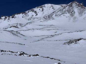
Travel in the backcountry with normal caution. Watch for potentially small, isolated wind slabs in very steep, extreme terrain or on unsupported slopes. It will be unlikely to trigger anything large enough to bury you, but a small avalanche can knock one off their feet. A variety of snow surface conditions exist depending on aspect and elevation. Some areas have better coverage from recent new snow than others. The west side of I-5 observed a few inches more snow than Mt. Shasta. Yesterday, westerly wind was evident and strong on the upper mountain, but most snow was blown off the mountain.
Recent Observations
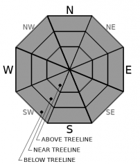
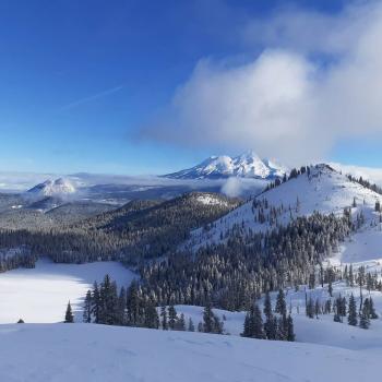
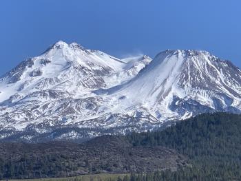
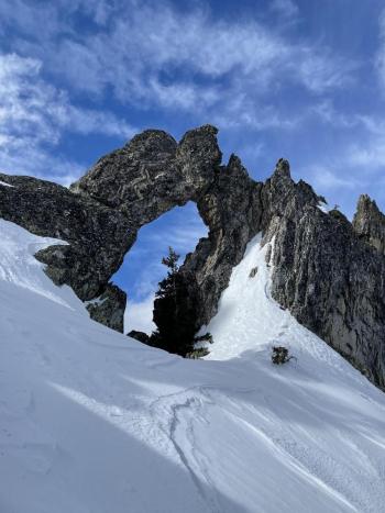
Recreational users brought in observations from Avalanche Gulch, Sun and Powder Bowl, Old Ski Bowl, Gray Butte and Castle Lake with no signs of instability or any recent avalanches. While I'm sure most sliders and riders were hoping for a bit more powder to the people, it was hard to beat the crisp, blue skies and 4-6 inches of fresh snow blanketing our two-week-old, tired and dirty snowpack. There was plenty of sunshine, and speaking of, it's that time of year when the sun is getting higher in the sky. Start thinking about the effects of sun on the snowpack and spring related instabilities like loose-wet avalanches. It's also that time of year to start remembering your sunscreen! Temperatures stayed cool though, and no roller balls or pinwheels were observed. Preserved powder will still linger on northerly facing slopes. Some sunny souths will have a sun crust on them today. Old tracks and wind features still protrude up through the snowpack. The new snow had fairly even distribution below treeline, much less so near and above treeline. Low-lying gullies host the best skiing. Westerly winds continue to blow up higher on the mountain. Snowpack totals across the area average 60-70 inches. For climbers, rockfall and smooth, slick conditions are still in play. Check out the Castle Lake and Mount Shasta observations from yesterday.
Weather and Current Conditions
Weather Summary
A cold front is moving inland with a narrow band of precipitation associated with it, but no precipitation is expected to make it to our area. We are going to get a brief break in the action today and tonight. Today there will be plenty of blue sky and more south/southwest wind over exposed terrain. A low pressure system will drop slowly to the south/southeast Monday into Tuesday. This will keep unsettled weather and bring snow showers to Siskiyou County. Snow levels will float in between 2 and 3,000 feet. Expect the precip to shut off by Wednesday evening.
24 Hour Weather Station Data @ 4:00 AM
| Weather Station | Temp (°F) | Wind (mi/hr) | Snow (in) | Comments | ||||||||
|---|---|---|---|---|---|---|---|---|---|---|---|---|
| Cur | Min | Max | Avg | Avg | Max Gust | Dir | Depth | New | Water Equivalent | Settlement | ||
| Mt. Shasta City (3540 ft) | 29 | 29 | 44 | 36.5 | 1 | N | ||||||
| Sand Flat (6750 ft) | 20 | 20 | 33 | 25 | Snow sensor down | |||||||
| Ski Bowl (7600 ft) | 18.5 | 18.5 | 28 | 22.5 | 69.3 | 0 | 0.4 | 0.5 | ||||
| Gray Butte (8000 ft) | 17.5 | 17.5 | 24.5 | 20.5 | 10 | 37 | W | |||||
| Castle Lake (5870 ft) | 22.5 | 22.5 | 41.5 | 28 | 64.7 | 0.7 | 0 | |||||
| Mount Eddy (6509 ft) | 22.5 | 19 | 29 | 23.5 | 2 | 5 | E | 62.5 | 0 | 0.2 | ||
| Ash Creek Bowl (7250 ft) | 20.5 | 19 | 27.5 | 22 | 59.4 | 0 | 0 | |||||
| Ash Creek Ridge (7895 ft) | 15.5 | 14.5 | 30.5 | 19 | 9 | 36 | SSE |
Two Day Mountain Weather Forecast
Produced in partnership with the Medford NWS
| For 7000 ft to 9000 ft | |||
|---|---|---|---|
|
Sunday (4 a.m. to 10 p.m.) |
Sunday Night (10 p.m. to 4 a.m.) |
Monday (4 a.m. to 10 p.m.) |
|
| Weather | Partly cloudy | Mostly cloudy | Snow showers. Snow level near town or lower. |
| Temperature (°F) | 33 | 21 | 23 |
| Wind (mi/hr) | Southwest 0-10 | Southwest 0-10 | South 0-10 |
| Precipitation SWE / Snowfall (in) | 0.01 / 0-0.50 | 0.12 / 0.50-1 | 0.42 / 3-5 |
| For 9000 ft to 11000 ft | |||
| Sunday | Sunday Night | Monday | |
| Weather | Mostly sunny, windy. | Mostly cloudy, windy. | Snow showers, windy. |
| Temperature (°F) | 15 | 7 | 7 |
| Wind (mi/hr) | Southwest 20-30 | South 15-25 | Southwest 20-30 |
| Precipitation SWE / Snowfall (in) | 0.01 / 0 | 0.12 / 0.50-1 | 0.42 / 3-5 |
Season Precipitation for Mount Shasta City
| Period | Measured (in) | Normal (in) | Percent of Normal (%) |
|---|---|---|---|
| From Oct 1, 2025 (the wet season) | 14.07 | 31.00 | 45 |
| Month to Date (since Jun 1, 2026) | 0.49 | 1.50 | 33 |
| Year to Date (since Jan 1, 2026) | 10.49 | 15.79 | 66 |

