Submitted by sclairmont on Tue, 01/10/2023 - 4:57am
Recent Observations:
The last 24 hours provided the first real break in storm conditions since January 4th. The sun poked out, heated up below and near treeline slopes, and gave the first glimpse of the upper mountain in a week.
An observation from Gray Butte yesterday described warm conditions down low. Roller balls, tree bombs, settling cracks, and heavy saturated snow were all prominent below 7,000 feet. Above 7,000 feet, snow surface conditions were cold, trees were rimed, and large wind drifts were abundant. A pit was dug on the west face of Gray Butte, mid-slope (~7,500 feet) with a NW aspect. Stable, well consolidated snow was found. No instabilities in the snowpack were observed yesterday.
A large amount of avalanche debris was found in the runout of the west face of Gray Butte yesterday. The debris was widespread and likely from the last 48 hours. This coincides well with the avalanche observation from two days ago in the Eddies. Both have a very similar timeline, size, aspect, and elevation. This suggests there was likely a widespread natural avalanche cycle in this last storm period.
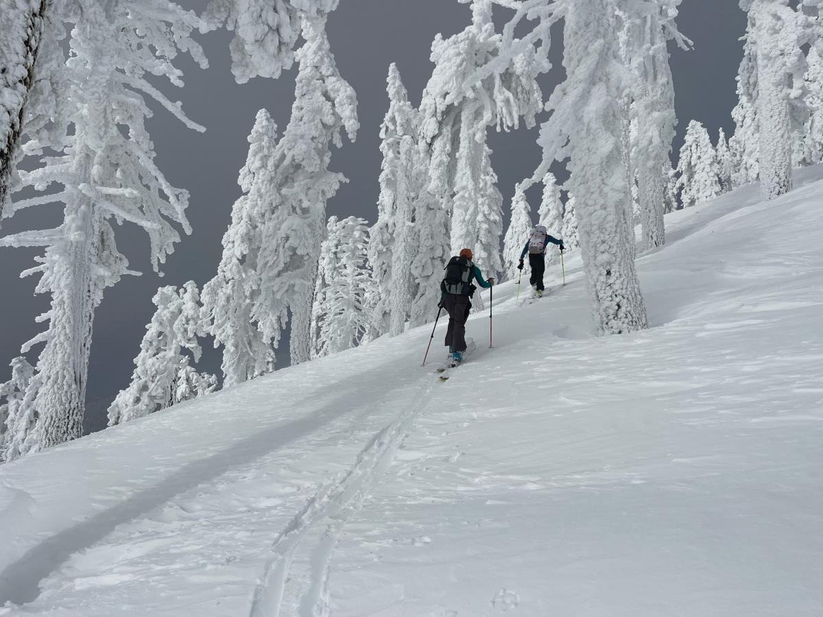
Photo: N. Meyers - SW face of upper Gray Butte (1-10-23)
Mountain Weather:
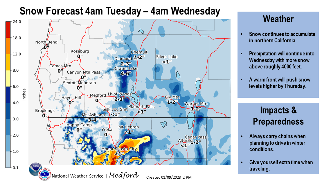
A strong low pressure system will be bringing more snow and wind to the Mount Shasta area this morning. This rapidly intensifying system will bring winter weather into the area by 4am and remaining for at least the next 24 hours. Precipitation forecasts are calling for 1.1 inches of water, which could equate to over a foot of snow. The highest precipitation rates will be seen this afternoon into the evening, then gradually tapering off late Wednesday. The National Weather Service has issued a winter storm warning in effect until 4pm today for areas above 3,500 feet. A winter storm watch is in effect starting this afternoon until Wednesday afternoon above 4,000 feet.
Below treeline, expect dense and wet snow conditions with freezing levels at 4,300 feet. Near and above treeline, expect blizzard like conditions. Winds will be strong gusting to extreme, snowfall will be intense, and visibility will be very poor.
On a different note, this storm has the potential to make road travel difficult today across all of Siskiyou county.
Media by NWS
Today 7-8 Weather :
Snow, heavy at times. Windy with gusts up to 45 mph. Snow level around 4,300 feet.
Today 7-8 Wind Direction:
SE
Today 8-9 Weather:
Snow, could be heavy at times. Wind chill values as low as -16. Windy, with gusts up to 85 mph.
Today 8-9 Wind Direction:
S
Tomorrow 7-8 Weather:
Snow showers before 1pm, then snow after 1pm. Snow could be heavy at times. Gusts up to 40 mph. Snow level around 4,300 feet.
Tomorrow 7-8 Wind Direction:
S
Tomorrow 8-9 Weather:
Snow showers before 1pm, then snow after 1pm. Snow could be heavy at times. Windy, with gusts up to 80 mph. Wind chill values as low as -15.
Tomorrow 8-9 Wind Direction:
SW
Tonight 7-8 Weather:
Snow showers. The snow could be heavy at times. Gusts up to 25 mph. Snow level dropping slightly to 4,200 feet.
Tonight 7-8 Wind Direction:
S
Tonight 8-9 Weather:
Snow showers. Snow could be heavy at times. Steady temperatures with wind chill values as low as -14. Windy, with gusts up to 90 mph.
Tonight 8-9 Wind Direction:
SW
27
26
28
27
83
14
0
19
18
32
25
129.5
2.4
0.89
Grey Butte Temp Max:
29.5
Grey Butte Temp Avg:
24.5
Grey Butte Wind Cur:
17.5
Grey Butte Wind Max:
25.5
Grey Butte Wind Gust Max:
55.2
Castle Lake Temp Avg:
32.5
Mount Eddy Temp Cur:
24.5
Mount Eddy Temp Avg:
27.5
Mount Eddy Wind Gust Max:
12.14
Mount Eddy Snow Depth:
99.7
Ash Creek Bowl Temp Cur:
25
Ash Creek Bowl Temp Min:
23
Ash Creek Bowl Temp Max:
25
Ash Creek Bowl Temp Avg:
23.5
Ash Creek Ridge Temp Cur:
20
Ash Creek Ridge Temp Min:
19
Ash Creek Ridge Temp Max:
26.5
Ash Creek Ridge Temp Avg:
22.5
Ash Creek Ridge Wind Cur:
0
Ash Creek Ridge Wind Max:
0
Ash Creek Ridge Wind Gust Max:
0
Mt. Shasta City Temp Cur:
35
Mt. Shasta City Temp Min:
35
Mt. Shasta City Temp Max:
46
Mt. Shasta City Temp Avg:
40
Mt. Shasta City Wind Cur:
3
Mt. Shasta City Wind Min:
0
Mt. Shasta City Wind Max:
5
Mt. Shasta City Wind Avg:
1
Mt. Shasta City Wind Avg:
N
Ash Creek Ridge Wind Min:
0
Ash Creek Ridge Wind Avg:
0
Sand Flat Snow Settlement:
0
Ski Bowl Snow Settlement:
0
Mount Eddy Snow Settlement:
0
Measured Precipitation Oct:
18.96
Normal Precipitation Oct:
14.18
Percent Precipitation Oct:
134
Measured Precipitation MTD:
9.83
Normal Precipitation MTD:
1.94
Percent Precipitation MTD:
507
Measured Precipitation YTD:
9.83
Normal Precipitation YTD:
1.94
Percent Precipitation YTD:
507
Tomorrow Wind Max 7-9:
20
Tomorrow Wind Min 7-9:
10
Tonight Wind Max 9-11:
45
Tomorrow Wind Max 9-11:
40
Tonight Wind Min 9-11:
35
Tomorrow Wind Min 9-11:
30
Today Snow Max 7-9:
16.00
Tonight Snow Max 7-9:
10.00
Tomorrow Snow Max 7-9:
8.00
Today Snow Min 7-9:
10.00
Tonight Snow Min 7-9:
6.00
Tomorrow Snow Min 7-9:
4.00
Today Snow Max 9-11:
20.00
Tonight Snow Max 9-11:
12.00
Tomorrow Snow Max 9-11:
9.00
Today Snow Min 9-11:
14.00
Tonight Snow Min 9-11:
8.00
Tomorrow Snow Min 9-11:
5.00
Weather Station Discussion:
The table below summarizes data reported from all of our weather stations over the last 24 hours.
Seasonal Stats Discussion:
The wet season is October 1 through May 1. The table below summarizes recorded vs. normal precipitation amounts for the City of Mount Shasta.
Overall Danger Rating:
Considerable


