Submitted by mmadden on Sun, 12/11/2022 - 4:10am
Recent Observations:
Blowing snow, freezing rain, deep powder, and low visibility have meant limited observations the past few days. Forecasters were able to trudge through the snow in the Castle Lake area last Thursday. They reported heavy snow, significant wind transport, and evidence of wind slab formation on leeward slopes. The storm crescendoed yesterday with high avalanche danger at all elevation bands. Whumpfing and cracking were reported by forecasters and the Mt. Shasta Ski Park Ski Patrol just outside the park boundary. A moderately-sized storm slab avalanche was investigated at the top of Coyote Butte yesterday which likely occurred early that morning. The avalanche was 60 cm (24 in) deep and 45 m (148 ft) across, running half way (235 m/775 ft) to the new Gray Butte ski lift. This avalanche fractured at a density change/interface within the recent storm snow. Forecasters have continued to monitor the strengthening facets and various crusts in the snowpack reported in previous observations. Any lingering surface hoar from Dec 7 that was buried on Dec 8 hasn't been seen intact or reactive within the snowpack. The winds and sun around Mt. Shasta tend to degrade surface hoar as quickly as it's formed, meaning it's not typically a concern for our area. That said, there have been limited observations from the field, both from forecasters and the public, regarding current snowpack and avalanche conditions. As the current storm gives way to sunny weather, remember to submit your snow, weather, and avalanche observations to the Mt. Shasta Avalanche Center.
Mountain Weather:
Today will be the last day of the current storm cycle which began last Thursday (12/8) bringing heavy snow, wind, and low visibility. The Mt. Shasta region has gained significant new snow with Gray Butte recording ~27" (69cm) and Mt. Eddy recording ~18" (46cm) since midday Thursday. We can expect a few more inches today as the low pressure system offshore begins departing south. Winds, averaging 13 mi/hr over the weekend, will taper down today and tomorrow. We can expect daytime temperatures to linger in the mid 20°s F (-4°C).
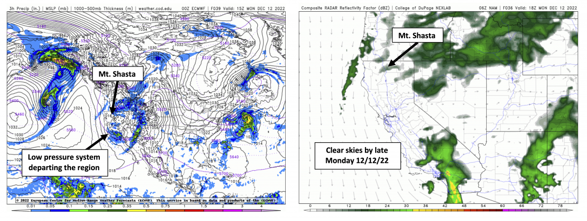
(left) Mean Sea Level Pressure (MSLP) forecast shows the low pressure system that brought the weekend's stormy weather departing to the south tomorrow. (right) Simulated radar reflectivity shows skies clearing throughout tomorrow.
Source: NexLab, College of DuPage
Today 7-8 Weather :
Overcast and snow showers. Snow level at 3,500ft dropping to 2,100ft by 10pm
Today 7-8 Wind Direction:
W
Today 8-9 Weather:
Overcast and snow showers.
Today 8-9 Wind Direction:
SW
Tomorrow 7-8 Weather:
Partly clouds. Snow level ~2,500ft
Tomorrow 7-8 Wind Direction:
W
Tomorrow 8-9 Weather:
Partly clouds.
Tomorrow 8-9 Wind Direction:
NW
Tonight 7-8 Weather:
Mostly cloudy with 40% change of snow showers. Snow level at ~1,900ft
Tonight 7-8 Wind Direction:
NE
Tonight 8-9 Weather:
Mostly cloudy with 40% change of snow showers.
Tonight 8-9 Wind Direction:
N
24
23
30
26
19
18.5
24.5
22
70.61
15.4
1.29
Grey Butte Temp Min:
18.5
Grey Butte Temp Max:
24.5
Grey Butte Temp Avg:
21.5
Grey Butte Wind Max:
23.5
Grey Butte Wind Gust Max:
42.93
Castle Lake Temp Cur:
25.5
Castle Lake Temp Min:
24.5
Mount Eddy Temp Cur:
19.5
Mount Eddy Temp Min:
19.5
Mount Eddy Temp Max:
27.5
Mount Eddy Wind Gust Max:
9.39
Mount Eddy Snow Depth:
46.39
Ash Creek Bowl Temp Cur:
21
Ash Creek Bowl Temp Min:
21
Ash Creek Bowl Temp Max:
26
Ash Creek Bowl Temp Avg:
23.5
Ash Creek Bowl Snow New:
9.8
Ash Creek Ridge Temp Cur:
17
Ash Creek Ridge Temp Min:
17
Ash Creek Ridge Temp Max:
23.5
Ash Creek Ridge Temp Avg:
20.5
Mt. Shasta City Temp Cur:
33
Mt. Shasta City Temp Min:
33
Mt. Shasta City Temp Max:
38
Mt. Shasta City Temp Avg:
34.5
Mt. Shasta City Wind Cur:
0
Mt. Shasta City Wind Min:
0
Mt. Shasta City Wind Max:
5
Mt. Shasta City Wind Avg:
2
Mt. Shasta City Wind Avg:
N
Ski Bowl Snow Settlement:
0
Mount Eddy Snow Settlement:
0
Ash Creek Bowl Snow Settlement:
0
Measured Precipitation Oct:
5.88
Normal Precipitation Oct:
7.76
Percent Precipitation Oct:
76
Measured Precipitation MTD:
2.55
Normal Precipitation MTD:
2.13
Percent Precipitation MTD:
120
Measured Precipitation YTD:
13.83
Normal Precipitation YTD:
33.14
Percent Precipitation YTD:
42
Tomorrow Wind Max 7-9:
12
Tonight Wind Max 9-11:
22
Tomorrow Wind Max 9-11:
18
Tonight Wind Min 9-11:
13
Tomorrow Wind Min 9-11:
8
Tonight Snow Max 7-9:
1.00
Tomorrow Snow Max 7-9:
0.00
Tonight Snow Min 7-9:
0.00
Tomorrow Snow Min 7-9:
0.00
Today Snow Max 9-11:
6.00
Tonight Snow Max 9-11:
1.00
Tomorrow Snow Max 9-11:
0.00
Today Snow Min 9-11:
3.00
Tonight Snow Min 9-11:
0.00
Tomorrow Snow Min 9-11:
0.00
Weather Station Discussion:
The table below summarizes data reported from all of our weather stations over the last 24 hours.
Seasonal Stats Discussion:
The wet season is October 1 through May 1. The table below summarizes recorded vs. normal precipitation amounts for the City of Mount Shasta.
Overall Danger Rating:
Considerable


