

Several storm slab avalanches large enough to bury, injury, or kill someone have occurred in the region over the past few days. These have initiated on a weak layer of graupel that briefly fell December 9th, helping separate the December 8-10 storm snow into two layers. The graupel layer can be a challenge to spot in the snowpack. The graupel is only 0.01-0.10 inches in size, comprises a relatively thin layer that's 2-3 ft deep. The avalanches reported on Coyote Butte and Gray Butte have all occurred on this layer near treeline in 36-39° terrain. They also initiated at sudden convex rolls where terrain below was open enough to allow an avalanche to run. Forecasters are uncertain as to the reactivity of this weak layer moving forward. It's not clear how widespread this layer is as reduced backcountry access from the recent storm has limited observations. Similar slopes adjacent to the recent avalanches haven't demonstrated comparable levels of reactivity. Given these observations and uncertainties, the avalanche danger for today was placed at moderate as isolated areas have been producing medium-to-large avalanches for the terrain. Forecasters will continue to monitor this layer's distribution and reactivity moving forward. As you go out to enjoy the sunny weather and new snow this week, help monitor the snowpack by reporting what you observe to the Mt. Shasta Avalanche Center.
Highlights of recently reported avalanche activity
- Dec 10, 2022 - A 2-ft deep, 148-ft wide natural slab avalanche D2/R4) on a NE aspect of Coyote Butte
- Dec 11, 2022 - A 2-ft deep, 60-ft wide skier triggered slab avalanche (D2/R3) on a west aspect of Gray butte.
- Dec 11, 2022 - A 8-ft deep, 100-ft wide slab avalanche reported in 3rd Chute at Mt. Ashland Ski Bowl when an artificially triggered 2-3ft deep slab avalanche stepped down to ground level.
- All three reported slab avalanches were big enough to bury, injure, or kill a person or group of people.
- All three reported slab avalanches initiated in the Dec 9-11 storm snow.
Today's weather forecast is the "calm after the storm." The low pressure system which brought snowy weather to Mt. Shasta Dec 8-11 has moved south and largely dissipated. High pressure will linger in the region this week bringing stable, sunny weather. This high pressure should ensure light winds and milder temperatures in the mountains. We can expect temperatures to gradually increase today and tomorrow, eventually settling into the mid- to low-30°s F moving into this week.
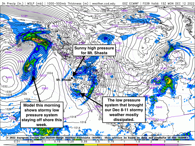
Mean Sea Level Pressure (MSLP) forecast model shows mostly sunny weather from high pressure in the region.
Source: NexLab, College of DuPage, ECMWF

