Submitted by mmadden on Mon, 12/05/2022 - 3:39am
Recent Observations:
The new snow yesterday was reported to be dry and low density making for excellent snowshoeing/skiing/snowboarding below treeline. The 12-hour snow total yesterday morning at Bunny Flat was 7 inches with another 5-8 inches falling overnight. A very thin ice layer was found separating the Nov 30-Dec 3 and Dec 4 new snow layers which was easily broken through while traveling. The past week of snow has remained relatively unconsolidated with 4F-F hardness.
In the past 72 hours, forecasters have found a widespread weak layer of sugary facets around the Nov 9-29 melt-freeze crust. So far, this layer has remained unreactive for forecasters but a public observation on Dec 2 reported easy fracturing of this layer around the crust. No avalanches have yet been reported on this layer. There is some uncertainty to the extent of this layer's reactivity, particularly with respect to elevation, as the avalanche center has no reports this past week from the ATL zone. There is some additional uncertainty as to how the snow might be settling above this melt-freeze crust. Forecasters will be heading out today to examine this facet layer in more detail and the extent to which the new snow might be consolidating into a slab. For now, a persistent weak layer problem remains out of the forecast as we gather more data.
Mountain Weather:
It's been a snowy couple of days for Mt. Shasta with 13.5" of new snow reported in the past 24 hours at Old Ski Bowl. The WINTER WEATHER ADVISORY from Saturday (12/3) has been extended until 4pm today. The low pressure system off the California coast will bring the last of this storm cycle's moisture into the area today as it departs southeast by Tuesday. We can expect continued snow showers this morning that gradually taper off as we approach tomorrow. Cool weather last night and today will help to preserve the new snow. Winds are expected to shift to the NW by Tuesday, potentially expanding the aspects with wind-loaded slopes. We can expect sunny weather and light winds on Tuesday--the calm after the storm.
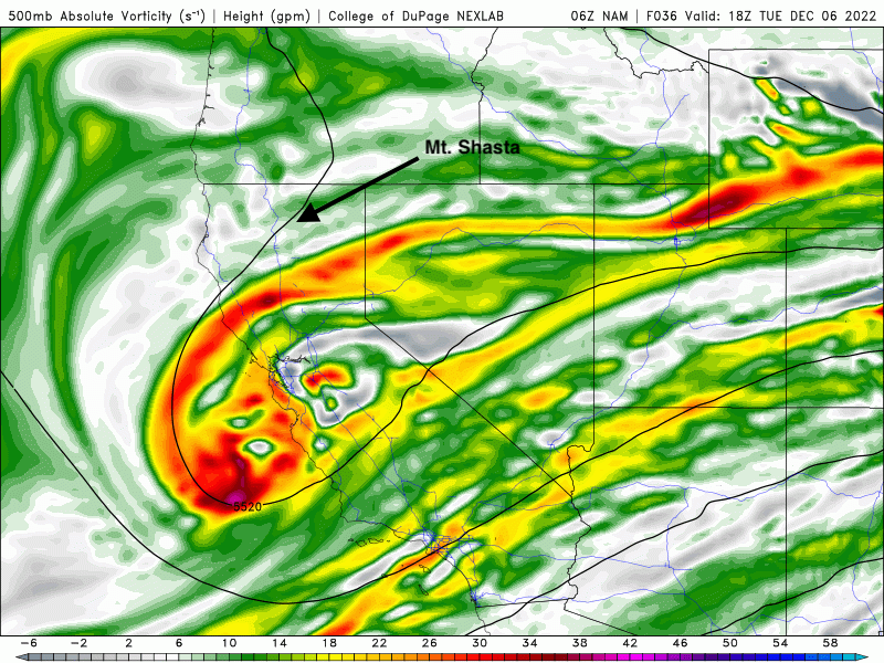
Models of 500mb vorticity help show the low pressure system departing the Mt. Shasta area by tomorrow morning.
Source: NAM, NexGen Weather Lab, College of DuPage
Today 7-8 Weather :
Overcast and snow showers. Snow level ~3,500'
Today 7-8 Wind Direction:
S
Today 8-9 Weather:
Overcast and snow showers. Snow level ~3,500'
Today 8-9 Wind Direction:
S
Tomorrow 7-8 Weather:
Mostly sunny. Snow level ~4,000'
Tomorrow 7-8 Wind Direction:
W-NW
Tomorrow 8-9 Weather:
Mostly sunny.
Tomorrow 8-9 Wind Direction:
W-NW
Tonight 7-8 Weather:
Partly cloudy with 20% chance of snow showers. Snow level ~2,500'
Tonight 7-8 Wind Direction:
S
Tonight 8-9 Weather:
Partly cloudy.
Tonight 8-9 Wind Direction:
SW
26
25
29
26
22
20.5
23.5
22
45.91
11.4
1.13
Grey Butte Temp Max:
22.5
Grey Butte Wind Gust Max:
36.8
Castle Lake Temp Max:
29.5
Castle Lake Temp Avg:
27.5
Mount Eddy Temp Min:
23.5
Mount Eddy Temp Avg:
25.5
Mount Eddy Wind Gust Max:
6.13
Mount Eddy Snow Depth:
28.67
Ash Creek Bowl Temp Cur:
22.5
Ash Creek Bowl Temp Min:
22.5
Ash Creek Bowl Temp Max:
24.5
Ash Creek Bowl Temp Avg:
23
Ash Creek Bowl Snow New:
4.3
Ash Creek Ridge Temp Cur:
19.5
Ash Creek Ridge Temp Min:
19
Ash Creek Ridge Temp Max:
21.5
Ash Creek Ridge Temp Avg:
20
Mt. Shasta City Temp Cur:
33
Mt. Shasta City Temp Min:
33
Mt. Shasta City Temp Max:
37
Mt. Shasta City Temp Avg:
35
Mt. Shasta City Wind Cur:
0
Mt. Shasta City Wind Min:
0
Mt. Shasta City Wind Max:
5
Mt. Shasta City Wind Avg:
2.5
Mt. Shasta City Wind Avg:
ESE
Ski Bowl Snow Settlement:
0
Mount Eddy Snow Settlement:
0.4
Ash Creek Bowl Snow Settlement:
0
Measured Precipitation Oct:
4.34
Normal Precipitation Oct:
6.46
Percent Precipitation Oct:
67
Measured Precipitation MTD:
1.01
Normal Precipitation MTD:
0.83
Percent Precipitation MTD:
122
Measured Precipitation YTD:
12.29
Normal Precipitation YTD:
31.84
Percent Precipitation YTD:
39
Tonight Wind Max 9-11:
15
Tomorrow Wind Max 9-11:
15
Tomorrow Wind Min 9-11:
5
Tonight Snow Max 7-9:
3.00
Tomorrow Snow Max 7-9:
0.00
Tonight Snow Min 7-9:
0.00
Tomorrow Snow Min 7-9:
0.00
Today Snow Max 9-11:
7.00
Tonight Snow Max 9-11:
3.00
Tomorrow Snow Max 9-11:
0.00
Today Snow Min 9-11:
3.00
Tonight Snow Min 9-11:
0.00
Tomorrow Snow Min 9-11:
0.00
Weather Station Discussion:
The table below summarizes data reported from all of our weather stations over the last 24 hours.
Seasonal Stats Discussion:
The wet season is October 1 through May 1. The table below summarizes recorded vs. normal precipitation amounts for the City of Mount Shasta.
Overall Danger Rating:
Considerable


