Submitted by sclairmont on Thu, 01/05/2023 - 5:35am
Recent Observations:
Observations from Gray Butte described weather trends as this storm was beginning to set in, as well as instability in the snowpack associated with our old surface crust. We experinced poor visibility, moderate snowfall, and light winds upon leaving the parking lot. While ascending Gray Butte, weather trends showed strengthening SE winds that were beginnning to transport snow from windward aspects and depositing them in the form of wind drifts, growing cornices, and wind loaded slopes. These observations represented mostly below tree line terrain and a little of above tree line. We also dug a pit on a west aspect, below tree line at an elevation of 7500 feet. Eight inches (20 cm) of new snow sat on top of the ~4mm surface crust, with old snow below. Upon performing an ECT, failure and full propagation occurred on isolation of the column (Q1). Failure plane was the old surface crust.
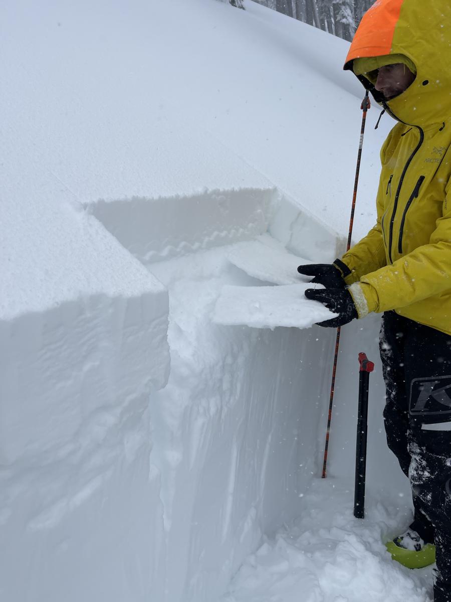
Photo: S. Clairmont, 1.4.2023 Gray Butte 7500'
From Parks Creek Summit area in the Eddy Mountains, sled-skiers described high winds creating the biggest hazard of the day. Multiple knocked over trees on the skin track and on the road were encountered. Precipitation increased during the day. Snowmobile and skin tracks quickly filled back in.
Mountain Weather:
It's wet out there folks, the storm has fully set in on the Mount Shasta area. Precipitation intensities have gradually increased starting yesterday into the night. Between 6pm and 12pm last night, the mountains picked up over 0.2 inches of water an hour. The town of Mount Shasta weather station collected nearly 0.3 inches of water in one hour (11pm), totaling ~2.7 inches of water in the last 24 hours. An avalanche warning is in effect for the surrounding area, and this will remain in effect through Sunday morning.
Today, precipitation and wind should remain high before gradually tapering off in the evening. During the day, Mount Shasta could see 10–14 inches of new snow near treeline. This evening, winds are forecast to decrease to moderate, with extreme gusts. Intensities will then pick back up in the morning of Friday (1/6).
With a series of low pressure systems continuing to develop and align in the pacific, Mount Shasta will continue to see higher precipitation for the imminent future. The Mount Shasta area is forecast to receive up to 7 inches of water in the next 6 days, and this is after last nights ~2.7 inches. For those who don't know, THAT IS A LOT OF WATER. This precipitation is well distributed over each day, with elevated intensities on Friday, Saturday, and Monday.
Do not underestimate the power and intensity of this storm. Observers have already run into down trees on roads and trails, and there have been numerous power outages in the region. With continued snowfall in the forecast, this is a good time to slow down, and watch this storm from a distance.
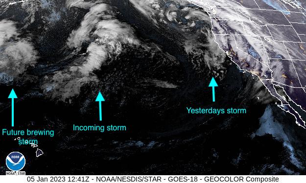
Photo by NOAA. 1/5/23 4:41am PST.
Today 7-8 Weather :
Snow. Chance of precipitation is 90 percent. Windy from the south strengthening throughout with gusts up to 65 mph.
Today 7-8 Wind Direction:
S
Today 8-9 Weather:
Snow, heavy a times. Chance of precipitation is 90 percent. Wind chill values as low as -10F. Windy from the south with gusts up to 70 mph and then weakening slightly throughout the day.
Today 8-9 Wind Direction:
S
Tomorrow 7-8 Weather:
Snow likely, mainly after 10am. Wind out of the south, with gusts up to 41 mph.
Tomorrow 7-8 Wind Direction:
S
Tomorrow 8-9 Weather:
Snow likely, mainly after 10am. Snow could be heavy at times. Wind chill values as low as -6F. Windy out of the south, gusting up to 47 mph.
Tomorrow 8-9 Wind Direction:
S
Tonight 7-8 Weather:
Snow likely, mainly after 10pm. Gusts up to 23 mph.
Tonight 7-8 Wind Direction:
S
Tonight 8-9 Weather:
Snow likely, mainly after 10pm. Wind chill values as low as -8F. Windy out of the south, gusting up to 47 mph, then weakening later in the evening.
Tonight 8-9 Wind Direction:
SW
26
20
26
24
50
0
0
29.5
21
29.5
25
79.39
6
1.38
Grey Butte Temp Cur:
28.5
Grey Butte Temp Avg:
23.5
Grey Butte Wind Gust Max:
61.34
Castle Lake Temp Avg:
31.5
Mount Eddy Temp Cur:
31.5
Mount Eddy Temp Max:
31.5
Mount Eddy Temp Avg:
27.5
Mount Eddy Wind Gust Max:
13.02
Mount Eddy Snow Depth:
50.86
Ash Creek Bowl Temp Cur:
25
Ash Creek Bowl Temp Min:
23
Ash Creek Bowl Temp Max:
25
Ash Creek Bowl Temp Avg:
23.5
Ash Creek Bowl Snow New:
4
Ash Creek Ridge Temp Cur:
25.5
Ash Creek Ridge Temp Min:
19.5
Ash Creek Ridge Temp Max:
28
Ash Creek Ridge Temp Avg:
23.5
Ash Creek Ridge Wind Cur:
0
Ash Creek Ridge Wind Max:
0
Ash Creek Ridge Wind Gust Max:
0
Mt. Shasta City Temp Cur:
41
Mt. Shasta City Temp Min:
34
Mt. Shasta City Temp Max:
44
Mt. Shasta City Temp Avg:
39.5
Mt. Shasta City Wind Cur:
4
Mt. Shasta City Wind Min:
0
Mt. Shasta City Wind Max:
6
Mt. Shasta City Wind Avg:
4
Ash Creek Ridge Wind Min:
0
Ash Creek Ridge Wind Avg:
0
Sand Flat Snow Settlement:
1
Ski Bowl Snow Settlement:
0
Mount Eddy Snow Settlement:
0
Ash Creek Bowl Snow Settlement:
0
Measured Precipitation Oct:
11.58
Normal Precipitation Oct:
13.1
Percent Precipitation Oct:
88
Measured Precipitation MTD:
2.45
Normal Precipitation MTD:
0.86
Percent Precipitation MTD:
285
Measured Precipitation YTD:
2.45
Normal Precipitation YTD:
0.86
Percent Precipitation YTD:
285
Tomorrow Wind Max 7-9:
20
Tomorrow Wind Min 7-9:
10
Tonight Wind Max 9-11:
30
Tomorrow Wind Max 9-11:
35
Tonight Wind Min 9-11:
20
Tomorrow Wind Min 9-11:
25
Today Snow Max 7-9:
14.00
Tonight Snow Max 7-9:
3.00
Tomorrow Snow Max 7-9:
9.00
Today Snow Min 7-9:
10.00
Tonight Snow Min 7-9:
1.00
Tomorrow Snow Min 7-9:
5.00
Today Snow Max 9-11:
22.00
Tonight Snow Max 9-11:
4.00
Tomorrow Snow Max 9-11:
10.00
Today Snow Min 9-11:
16.00
Tonight Snow Min 9-11:
2.00
Tomorrow Snow Min 9-11:
6.00
Weather Station Discussion:
The table below summarizes data reported from all of our weather stations over the last 24 hours.
Seasonal Stats Discussion:
The wet season is October 1 through May 1. The table below summarizes recorded vs. normal precipitation amounts for the City of Mount Shasta.
Overall Danger Rating:
High


