

You are here
Avalanche Advisory for 2017-03-13 07:02:18
- EXPIRED ON March 14, 2017 @ 7:02 amPublished on March 13, 2017 @ 7:02 am
- Issued by Andrew Kiefer - Mt Shasta Avalanche Center
Bottom Line
The avalanche danger is LOW on all aspects and at all elevations. Loose wet avalanches remain the primary concern. The likelihood of triggering an avalanche will increase throughout the day as snow surfaces melt and become unconsolidated. Falling rime ice presents a significant objective hazard as well. Watch for falling ice in the alpine, and also for its potential to trigger wet loose slides on slopes below.


Avalanche Problem 1: Loose Wet
-
Character ?

-
Aspect/Elevation ?
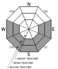
-
Likelihood ?CertainVery LikelyLikelyPossible
 Unlikely
 -
Size ?HistoricVery LargeLargeSmall

Wet loose avalanches will become a concern with incoming solar radiation and warming temperatures throughout the day. E-SE-S-SW-W aspects near and below treeline on slopes steeper than 30 degrees are where backcountry travelers will mostly likely encounter today’s avalanche problem. Watch for roller balls and pinwheels as snow surfaces melt, and monitor changing boot and ski penetration. Be intentional with your timing, and avoid steep slopes in the afternoon that present wet and unconsolidated snow surfaces.
A loose wet avalanche is a release of unconsolidated snow or slush. It starts at a point and entrains snow as it moves downhill. A terrain trap such as a gully, cliff, or an abrupt transition like a flat lake can magnify the consequences of wet loose avalanches.
Forecast Discussion
Sunny, warm, and beautiful weather will continue today, making for springtime conditions. The surface of the snowpack is transitioning, and has undergone uniform melt-freeze cycles over the past 48 hours. Warming temperatures and intense solar radiation will melt snow surfaces, and the likelihood for wet loose avalanche activity will increase throughout the day. Falling rime ice also presents a significant hazard for anyone venturing high into the alpine, and has the potential to trigger wet loose avalanches on slopes below.
Recent Observations
Very warm temperatures and intense solar radiation put snow surfaces to the test yesterday. Surprisingly, loose wet avalanche activity was minimal throughout the advisory area. Falling rime ice in the alpine posed the greatest objective hazard on Mount Shasta. Large rime ice formations were widespread throughout upper elevation rock outcrops, and evidence was found of previous falling rime ice triggering small wet loose avalanches on south and east facing slopes below.
The top 10-15cm of the snowpack has begun a melt-freeze cycle. Snow surfaces were firm and frozen yesterday morning, and a mid morning warm up allowed for a window of decent corn skiing on sun-exposed slopes between 8000-10000ft. By 2pm yesterday, ski quality deteriorated as snow surfaces became sticky and unconsolidated up to 9500ft with 10-15cm of boot penetration.
Weather and Current Conditions
Weather Summary
A strong ridge of high pressure over the advisory area will bring sunny skies and warm temperatures again today. Increasing westerly winds are expected, and flow aloft will begin to shift to the southwest this afternoon. A change in the clear weather pattern may come as early as tomorrow night. Precipitation is very likely by Wednesday, as a low-pressure system brings waves of moisture to northern California. Freezing levels look to be near 8500ft during this time.
===========================================================
In Mt Shasta City at 0500, we have a current temperature of 36 F.
On Mt Shasta (South Side) in the last 24 hours...
Sand Flat - 6750 ft, the current temperture is 31 degrees F. Temperatures have ranged from 29 F to 55 F. Snow on the ground totals 106 inches with no new snow and 3 inches of settlement.
Old Ski Bowl - 7,600ft. the current temperature is 39 degrees F. Temperatures have ranged from 32 F to 53 F. Snow on the ground totals 181 inches with no new snow and 3 inches of settlement.
Gray Butte - 8,000 feet, the current temperature is 44 degrees F. Temperatures have ranged from 35 F to 52 F. Winds have averaged 5-15 mph with gusts to 28 mph out of the west/northwest.
Mt Eddy Range (West side of Interstate-5)...
Castle Lake - 5,800 feet, the current temperature is 42 degrees F. Temperatures have ranged from 35 F to 59 F. Snow on the ground totals 107 inches with no new snow and 2 inches of settlement.
Mt Eddy - 6,500 feet, the current temperature is 35 degrees F. Temperatures have ranged from 30 F to 52 F. Snow on the ground measures 99 inches with no new snow and 2 inches of settlement. Winds have averaged 2-5 mph with gusts to 7 mph blowing out of the west/southwest.
THIS SEASON PRECIPITATION for MT SHASTA CITY: Since October 1st (the wet season), we have received 43.67 inches of water, normal is 32.37 inches, putting us at 135% of normal. For the month of March, we have received .36 inches of water, normal is 2.87 inches, which is 13% of normal. And finally for the year of 2017, we received 22.51 inches of water, normal is 17.16 inches, putting us at 131% of normal.
Always check the weather before you attempt to climb Mt Shasta. Further, monitor the weather as you climb. Becoming caught on the mountain in any type of weather can compromise life and limb. Be prepared.
| 0600 temperature: | 31 |
| Max. temperature in the last 24 hours: | 55 |
| Average wind direction during the last 24 hours: | West/Northwest |
| Average wind speed during the last 24 hours: | 5-10 mi/hr |
| Maximum wind gust in the last 24 hours: | 25 mi/hr |
| New snowfall in the last 24 hours: | 0 inches |
| Total snow depth: | 107 inches |
Two Day Mountain Weather Forecast
Produced in partnership with the Medford NWS
| For 7000 ft to 9000 ft | |||
|---|---|---|---|
|
Monday (4 a.m. to 10 p.m.) |
Monday Night (10 p.m. to 4 a.m.) |
Tuesday (4 a.m. to 10 p.m.) |
|
| Weather | Sunny | Mostly Clear | Mostly Sunny |
| Temperature (°F) | 58 | 40 | 54 |
| Wind (mi/hr) | Northwest 7-9 | West/Northwest becoming Southeast 7-9 mph | South 9-13 mph |
| Precipitation SWE / Snowfall (in) | / 0 | / 0 | / 0 |
| For 9000 ft to 11000 ft | |||
| Monday | Monday Night | Tuesday | |
| Weather | Sunny and Breezy | Mostly Clear and Windy | Mostly Sunny and Windy |
| Temperature (°F) | 35 | 31 | 31 |
| Wind (mi/hr) | West 25-30 mph | West/Southwest 0 | Southwest 29-37 mph |
| Precipitation SWE / Snowfall (in) | / 0 | / 0 | / 0 |

