

You are here
Avalanche Advisory for 2018-03-25 06:53
- EXPIRED ON March 26, 2018 @ 6:53 amPublished on March 25, 2018 @ 6:53 am
- Issued by Andrew Kiefer - Mt Shasta Avalanche Center
Bottom Line
Heightened avalanche conditions exist near and above treeline on wind loaded slopes 35 degrees and steeper. Human-triggered wind slab avalanches are possible. Careful snowpack evaluation is essential today as skies clear and the 5-day storm cycle comes to a close.


Avalanche Problem 1: Wind Slab
-
Character ?

-
Aspect/Elevation ?
-
Likelihood ?CertainVery LikelyLikelyPossible
 Unlikely
 -
Size ?HistoricVery LargeLargeSmall

Gale force winds paired with 2-3 ft of recent snow have created wind slabs on all aspects near and above treeline. Wind slabs could be several feet thick, and could be triggered by skiers and riders on slopes 35 degrees and steeper. Over the past 4 days, winds have been steady out of the W/SW with gusts close to 5 0 mph at 8,000 ft. Continued winds over the next 24 hours will aid in the development of existing wind slabs. Blowing snow, wind drifts, shooting cracks, wind eroded snow surfaces and hollow sounding snow are all signs of the wind slab problem. Look for wind slabs in leeward terrain near and above treeline, primarily on easterly aspects. Avoid the problem by sticking to protected or wind scoured areas and lower angle terrain.
Forecast Discussion
Our snowpack is adjusting to the recent load of new snow. Avalanches and several signs of instability have been observed during the storm. Today, it is possible to trigger a wind slab avalanche large enough to kill a person.
Shallow storm slabs, dry loose slouging and small cornices have also been observed recently. It is crucial to evaluate snow and terrain carefully today and make conservative decisions.
Recent Observations
An additional 4 inches of new snow was recorded over the past 24 hours at the Old Ski Bowl weather station. Our storm total at this location since 03/20 is 33 inches of snow (2.31 inches of snow water equivalent). The most snow accumulation occurred Friday evening (17 inches of cold, dry snow), with high freezing levels and rain on snow up to 7,500 ft earlier in the storm. Southwest winds have been strong and gusty for the past several days.
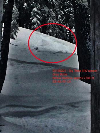
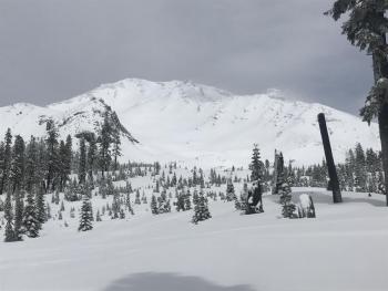
A small and shallow storm slab avalanche was skier triggered yesterday below treeline on a northwest facing aspect on Grey Butte (see observation). Skiers also found stiff wind slabs near treeline in a cross loaded area on a WNW facing aspect, and shooting cracks were observed (see photo below).
The low-density storm snow received since Friday has bonded poorly to the old snow surface. Westerly winds have transported snow onto leeward aspects near and above treeline and created drifts and wind slabs 2-4 ft deep. Exposed terrain features are scoured. Wind slabs and stiff wind-textured snow surfaces exist above 8,000 ft.

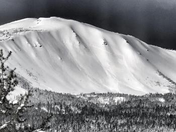
Shooting crack at 8600 ft on a WNW aspect on Mount Shasta (3/24/18, J. Koster Photo)
Weather and Current Conditions
Weather Summary
Light snow showers will continue this morning with clearing skies throughout the day. Highs will reach the lower 30s at 7,000 ft with 15-20 mph northwest winds expected above treeline. Conditions will dry out tonight and tomorrow as high pressure builds over northern California. Tomorrow will bring mostly sunny skies with strong and gusty north winds. Warm spring temperatures and sunshine will come later in the week as high pressure continues.
24 Hour Weather Station Data @ 6:00 AM
| Weather Station | Temp (°F) | Wind (mi/hr) | Snow (in) | Comments | ||||||||
|---|---|---|---|---|---|---|---|---|---|---|---|---|
| Cur | Min | Max | Avg | Avg | Max Gust | Dir | Depth | New | Water Equivalent | Settlement | ||
| Mt. Shasta City (3540 ft) | 29 | 24 | 39 | 31 | 2 | N | ||||||
| Sand Flat (6750 ft) | station down | |||||||||||
| Ski Bowl (7600 ft) | 13.5 | 7.5 | 36 | 16.5 | 94.5 | 4 | 0.26 | 3.5 | ||||
| Gray Butte (8000 ft) | 12.5 | 8 | 23 | 14.5 | 9 | 31 | WNW | |||||
| Castle Lake (5870 ft) | station down | |||||||||||
| Mount Eddy (6509 ft) | 15.5 | 9.5 | 26 | 17.5 | 1 | 9 | SW | 55 | 4 | 3 | ||
| Ash Creek Bowl (7250 ft) | station down | |||||||||||
| Ash Creek Ridge (7895 ft) | station donw |
Two Day Mountain Weather Forecast
Produced in partnership with the Medford NWS
| For 7000 ft to 9000 ft | |||
|---|---|---|---|
|
Sunday (4 a.m. to 10 p.m.) |
Sunday Night (10 p.m. to 4 a.m.) |
Monday (4 a.m. to 10 p.m.) |
|
| Weather | A 50% chance of snow showers in the morning then becoming partly sunny. | A 20 percent chance of snow showers before 11pm then partly cloudy. | Mostly sunny |
| Temperature (°F) | 30 | 15 | 36 |
| Wind (mi/hr) | NW 0-5 mi/hr | NW 0-5 mi/hr | N 5-10 mi/hr |
| Precipitation SWE / Snowfall (in) | / 0-.5 | / 0-.5 | / 0 |
| For 9000 ft to 11000 ft | |||
| Sunday | Sunday Night | Monday | |
| Weather | A 50 percent chance of snow showers. Partly sunny and cold. Wind chill values as low as -21. | A 20 percent chance of snow showers before 11pm. Partly cloudy. Wind chill values as low as -22. | Mostly sunny and windy. Wind chill values as low as -19. |
| Temperature (°F) | 2 | 2 | 21 |
| Wind (mi/hr) | NW 10-15 mi/hr | NW 0-1 | N 30-40 mi/hr |
| Precipitation SWE / Snowfall (in) | / 0-1 | / 0-.5 | / 0 |
Season Precipitation for Mount Shasta City
| Period | Measured (in) | Normal (in) | Percent of Normal (%) |
|---|---|---|---|
| From Oct 1, 2025 (the wet season) | 15.95 | 34.50 | 46 |
| Month to Date (since Jun 1, 2026) | 5.06 | 5.00 | 101 |
| Year to Date (since Jan 1, 2026) | 10.12 | 19.29 | 52 |

