

You are here
Avalanche Advisory for 2018-03-30 05:54
- EXPIRED ON March 31, 2018 @ 5:54 amPublished on March 30, 2018 @ 5:54 am
- Issued by Nick Meyers - Shasta-Trinity National Forest
Bottom Line
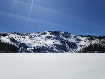
Avalanche danger is LOW at all elevations and aspects. Melt-freeze cycles are in the making. Exercise normal caution and watch for small, isolated wind slabs above treeline and loose wet activity near and below treeline. Be wary of falling rime ice on the upper mountain.


Avalanche Problem 1: Normal Caution
-
Character ?

-
Likelihood ?CertainVery LikelyLikelyPossible
 Unlikely
 -
Size ?HistoricVery LargeLargeSmall

Generally safe avalanche conditions exist in the backcountry. LOW avalanche danger does not mean NO avalanche danger:
- Watch for small isolated wind slabs where areas of drifting have occurred and firm layers of surface snow overlie softer layers.
- Warm weather and solar radiation may cause small loose wet avalanches on S/E facing slopes. To avoid, travel when the snow surface is colder and stronger. Plan your trips to avoid crossing on or under very steep sunlit slopes.
- Small cornices exist on easterly aspects. Increasing temperatures may weaken these causing them to fall. Avoid traveling on top or below them.
Forecast Discussion
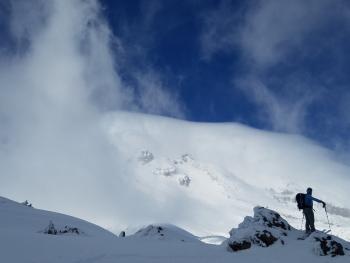
For the time being, loose wet snow instabilities will be the name of the game. While these instabilities will be mostly inconsequential, pay attention to snow surface conditions on slopes facing the sun during those warm afternoon hours. Roller balls and pin wheels are indicators that you may want to move onto a different aspect or come back a bit earlier another day. Almost every spring, Avalanche Gulch produces a couple large, loose wet slides. Anything is possible in the Spring: A warm and sunny spell can quickly be followed by a late season storm hosting whiteout conditions with new snow and associated wind and storm slab avalanche problems. Be prepared, check the weather and make good decisions as climbing season approaches.
Recent Observations
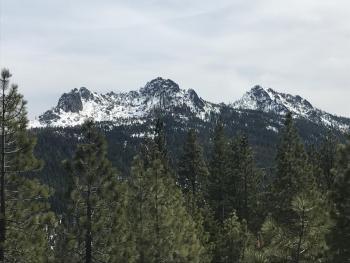
Yesterday's high reached 50 degrees F at 7,800 feet on Mount Shasta. Overnight low's bottomed out at 36 degrees F. These temps were identical to the day prior. Gray Butte continues to report light winds, easterly in nature. Firm snow in the morning and soft but supportable snow in the afternoon was observed on a tour of the west side of the forecast area yesterday. A day of snow survey from the South Fork Sac road (launched .5 miles past the second bridge) brought us to Mumbo Basin and Whalen Summit. Average snow depths in the basin were 20 inches. Average depth at Whalen summit was 9 inches. Small streams were running and the snow is melting fast. It was short sleeve weather all day with calm wind. No loose wet associated instabilities were observed.
Weather and Current Conditions
Weather Summary
The upper ridge that has brought mild weather to the area remains in control today. The air mass aloft is nearly identical to yesterday, temperature-wise. Upstream, satellite imagery is showing plenty of high level clouds that are directed toward Oregon. These will likely drift over the area today. If the clouds are thick enough, we may see slightly lower temperatures than yesterday. Regardless, it's going to be another mild, spring day with no precipitation. A more active pattern is shaping up for late next week.
24 Hour Weather Station Data @ 4:00 AM
| Weather Station | Temp (°F) | Wind (mi/hr) | Snow (in) | Comments | ||||||||
|---|---|---|---|---|---|---|---|---|---|---|---|---|
| Cur | Min | Max | Avg | Avg | Max Gust | Dir | Depth | New | Water Equivalent | Settlement | ||
| Mt. Shasta City (3540 ft) | 39 | 37 | 70 | 53 | 4 | |||||||
| Sand Flat (6750 ft) | station down | |||||||||||
| Ski Bowl (7600 ft) | 40 | 36.5 | 50.5 | 43 | 80.2 | 0 | 0 | 2.1 | ||||
| Gray Butte (8000 ft) | 41.5 | 39.5 | 50.5 | 44 | 4 | 12 | SE | |||||
| Castle Lake (5870 ft) | 0 | 0 | 0 | 0 | 0 | 0 | 0 | station down | ||||
| Mount Eddy (6509 ft) | 38.5 | 37.5 | 54 | 44.5 | 2 | 10 | WSW | 45.7 | 0 | 2.5 | ||
| Ash Creek Bowl (7250 ft) | station down | |||||||||||
| Ash Creek Ridge (7895 ft) | station down |
Two Day Mountain Weather Forecast
Produced in partnership with the Medford NWS
| For 7000 ft to 9000 ft | |||
|---|---|---|---|
|
Friday (4 a.m. to 10 p.m.) |
Friday Night (10 p.m. to 4 a.m.) |
Saturday (4 a.m. to 10 p.m.) |
|
| Weather | Partly cloudy | Partly cloudy | Mostly cloudy in the morning, then becoming partly cloudy |
| Temperature (°F) | 58 | 37 | 58 |
| Wind (mi/hr) | NW 0-5 mi/hr | NW 0-5 mi/hr | W 0-5 mi/hr |
| Precipitation SWE / Snowfall (in) | / 0 | / 0 | / 0 |
| For 9000 ft to 11000 ft | |||
| Friday | Friday Night | Saturday | |
| Weather | Partly cloudy and windy. | Partly cloudy and windy. | Mostly cloudy in the morning, then becoming partly cloudy, windy. |
| Temperature (°F) | 35 | 31 | 31 |
| Wind (mi/hr) | NW 15-20 mi/hr | W 0 | W 15-20 mi/hr |
| Precipitation SWE / Snowfall (in) | / 0 | / 0 | / 0 |
Season Precipitation for Mount Shasta City
| Period | Measured (in) | Normal (in) | Percent of Normal (%) |
|---|---|---|---|
| From Oct 1, 2025 (the wet season) | 15.95 | 35.20 | 45 |
| Month to Date (since Jun 1, 2026) | 5.06 | 5.70 | 89 |
| Year to Date (since Jan 1, 2026) | 10.12 | 19.99 | 51 |

