

You are here
Avalanche Advisory for 2018-01-13 05:31:23
- EXPIRED ON January 14, 2018 @ 5:31 amPublished on January 13, 2018 @ 5:31 am
- Issued by Nick Meyers - Shasta-Trinity National Forest
Bottom Line
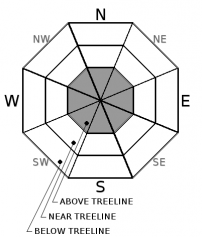
Triggering an avalanche is unlikely, and LOW avalanche danger exists at all elevations. Watch for unstable snow on isolated terrain features. Shallow snowpack hazards are still problematic below treeline. Use extreme caution on steep slopes at upper elevations where firm snow surfaces are widespread. Falling rime ice will be a serious hazard today with warming temperatures.


Avalanche Problem 1: Normal Caution
-
Character ?

-
Aspect/Elevation ?
-
Likelihood ?CertainVery LikelyLikelyPossible
 Unlikely
 -
Size ?HistoricVery LargeLargeSmall

Normal caution is advised:
- Watch for isolated slabs.
- Ski and ride one at a time in avalanche terrain.
- Don't regroup in run out zones
- Basic avalanche rescue skills are always essential when you travel in avalanche terrain.
Isolated slabs are generally related to wind and terrain: look for places where small areas of drifting have may have occurred and firm layers of surface snow overlie softer layers. Often this will occur on the lee side of ridges, in terrain depressions, on convex terrain features, and in the lee of isolated bands of trees.
Forecast Discussion
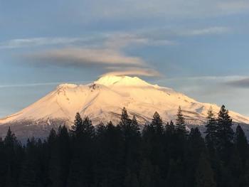
Today, falling RIME ICE will be our top concern. Temperatures are expected to warm upwards of 10 degrees F higher than previous days high temps with mild wind speeds. This will likely cause a maelstrom of rime ice to plummet down any slope below exposed, rime ice plastered rock features on Mount Shasta. Do not take this lightly. Rime ice can function just like a rock and cause serious injury or death, if large enough. Small, medium and large chunks are possible. We strongly advise wearing a helmet if you must go....but perhaps stay off suspect slopes altogether!
Recent Observations
- No recent avalanches or signs of instability, south side of Mount Shasta
- Extremely variable
- TONS of rime ice plastered to exposed rock formations, no exaggeration here.
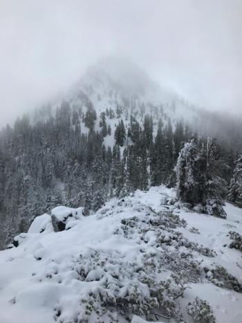
- Slick/glazed snow surfaces near treeline, breakable crust mid elevations, some softening on select southeasterly slopes
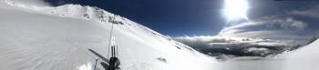
- Breezy near and above treeline, west/northwest
- Thin snowpack with many hazards below treeline
- Castle Lake has no snow, lake is not frozen
- Eddy Mountains have very little snow, 6-12 in (15-30 cm) average depth near/above treeline, hard, supportable (One is able to drive with high clearance 4WD to Parks Creek Summit, 9.3 miles from Stewart Springs. Snow encountered at 7.0 miles.)
- Pilgrim Creek Snowmobile Park is snowless, one can drive to at least Brewer Creek road on Military Pass, if not further with 4WD
Weather and Current Conditions
Weather Summary
High pressure takes the stand and will ring in the weekend with clear skies and dry weather. Patchy fog can be expected in the valleys. Winds are mellow and overall, there isn't much to mention weather-wise. All eyes are focused on next week, honestly. The aforementioned "parade of storms" is still on track. Storm precipitation amounts look to progressively increase over the course of the week, and snow levels will gradually lower. By next weekend, we should have significant snow in the hills. We usually don't like to put the cart before the horse, but can I get a hallelujah?
-------------------------
THIS SEASON PRECIPITATION for MT SHASTA CITY: Since October 1st (the wet season), we have received 7.81 inches of water, normal is 18.10 inches, putting us at 43% of normal. For the month of January and 2018, we have received 1.98 inches of water, normal is 2.89 inches, which is 68% of normal.
Always check the weather before you attempt to climb Mount Shasta. Further, monitor the weather as you climb. Becoming caught on the mountain in any type of weather can compromise life and limb. Be prepared.
24 Hour Weather Station Data @ 4:00 AM
| Weather Station | Temp (°F) | Wind (mi/hr) | Snow (in) | Comments | ||||||||
|---|---|---|---|---|---|---|---|---|---|---|---|---|
| Cur | Min | Max | Avg | Avg | Max Gust | Dir | Depth | New | Water Equivalent | Settlement | ||
| Mt. Shasta City (3540 ft) | 30 | 30 | 51 | 39 | 1 | N | ||||||
| Sand Flat (6750 ft) | 32 | 27 | 37 | 31 | 11 | 0 | 0 | 0 | ||||
| Ski Bowl (7600 ft) | 40 | 22 | 43 | 35 | 24 | 0 | 0 | 0 | ||||
| Gray Butte (8000 ft) | 41 | 22 | 42 | 35 | 7 | 25 | WNW | |||||
| Castle Lake (5870 ft) | 43 | 30 | 43 | 37 | 0 | 0 | 0 | |||||
| Mount Eddy (6509 ft) | 37 | 27 | 43 | 38 | 2 | 7 | WSW | 0 | 0 | 0 | ||
| Ash Creek Bowl (7250 ft) | Station down | |||||||||||
| Ash Creek Ridge (7895 ft) | Station down |
Two Day Mountain Weather Forecast
Produced in partnership with the Medford NWS
| For 7000 ft to 9000 ft | |||
|---|---|---|---|
|
Saturday (4 a.m. to 10 p.m.) |
Saturday Night (10 p.m. to 4 a.m.) |
Sunday (4 a.m. to 10 p.m.) |
|
| Weather | Sunny | Mostly Clear | Sunny |
| Temperature (°F) | 52 | 40 | 53 |
| Wind (mi/hr) | East 0-5 mph | East 0-5 mph | East 10-15 mph |
| Precipitation SWE / Snowfall (in) | / 0 | / 0 | / 0 |
| For 9000 ft to 11000 ft | |||
| Saturday | Saturday Night | Sunday | |
| Weather | Sunny | Mostly clear | Sunny and windy |
| Temperature (°F) | 39 | 34 | 41 |
| Wind (mi/hr) | Southeast 5-10 mph | Southeast 0 | South 15-25 mph |
| Precipitation SWE / Snowfall (in) | / 0 | / 0 | / 0 |

