

You are here
Avalanche Advisory for 2018-01-14 06:43:47
- EXPIRED ON January 15, 2018 @ 6:43 amPublished on January 14, 2018 @ 6:43 am
- Issued by Andrew Kiefer - Mt Shasta Avalanche Center
Bottom Line
LOW avalanche danger exists at all elevations. Falling rime ice will be a significant hazard above treeline on Mount Shasta today. A series of storms beginning tomorrow night will bring snowfall and changing conditions throughout the week.


Avalanche Problem 1: Normal Caution
-
Character ?

-
Aspect/Elevation ?
-
Likelihood ?CertainVery LikelyLikelyPossible
 Unlikely
 -
Size ?HistoricVery LargeLargeSmall

Normal caution is advised:
- Ski and ride one at a time in avalanche terrain.
- Don't regroup in run out zones.
- Basic avalanche rescue skills are always essential when you travel in avalanche terrain.
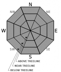
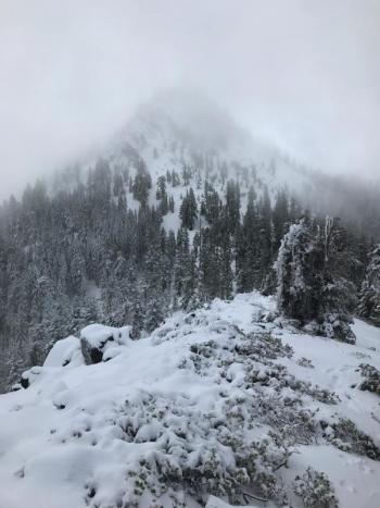
The thin, icy snowpack continues to create backcountry travels hazards. Steep terrain above treeline is challenging and dangerous. Arresting a fall in these conditions is difficult. Watch for rocks and patches of bare ground below treeline.
Forecast Discussion
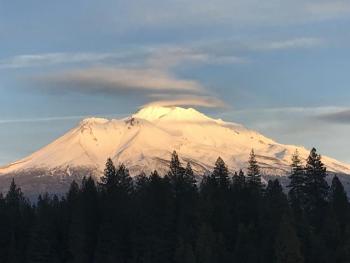
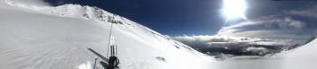
Snowpack stability is good, and generally safe avalanche conditions exist. Watch for unstable snow on steep slopes facing south and east above 9,000ft. Although unlikely, small wet loose avalanches could be a concern in these isolated areas. Falling rime ice is expected above treeline on Mount Shasta today. Be especially careful in Avalanche Gulch below Redbanks, the Trinity Chutes, and Casaval Ridge.
Recent Observations
Steady 15-25mph easterly winds blew yesterday near and above treeline. Sunshine and highs in the mid 50s allowed snow surfaces to soften. A small wet loose avalanche occurred on a southeast aspect near 10,000ft in the Old Ski Bowl in the afternoon. Plenty of rime ice came down off rock features in the alpine on Mount Shasta. Slick snow surfaces can be found above treeline. Shallow snowpack hazards continue to exist below treeline. Mount Shasta has the only useable snowpack in the advisory area.
Weather and Current Conditions
Weather Summary
High pressure will weaken and move eastward today and tonight. Expect partly cloudy skies, highs in the 50s and moderate southeast winds. Patchy fog will continue in the valleys. Low pressure and a series of storms will approach the Pacific Northwest beginning tomorrow. Light precipitation will spread throughout the area by late afternoon and evening. High snow levels between 6,500-7,500ft and gusty southwest winds are expected with this first frontal passage. Snow should begin to accumulate on Tuesday. Heavy precipitation and fluctuating snow levels are expected Wednesday through Friday.
-------------------------
THIS SEASON PRECIPITATION for MT SHASTA CITY: Since October 1st (the wet season), we have received 7.81 inches of water, normal is 18.34 inches, putting us at 43% of normal. For the month of January and 2018, we have received 1.98 inches of water, normal is 3.13 inches, which is 63% of normal.
Always check the weather before you attempt to climb Mount Shasta. Further, monitor the weather as you climb. Becoming caught on the mountain in any type of weather can compromise life and limb. Be prepared.
24 Hour Weather Station Data @ 4:00 AM
| Weather Station | Temp (°F) | Wind (mi/hr) | Snow (in) | Comments | ||||||||
|---|---|---|---|---|---|---|---|---|---|---|---|---|
| Cur | Min | Max | Avg | Avg | Max Gust | Dir | Depth | New | Water Equivalent | Settlement | ||
| Mt. Shasta City (3540 ft) | 35 | 30 | 52 | 40 | 3 | SW | ||||||
| Sand Flat (6750 ft) | 38 | 32 | 53 | 39 | 11 | 0 | 0 | 0 | ||||
| Ski Bowl (7600 ft) | 47 | 40 | 48 | 45 | 23 | 0 | 0 | 0 | ||||
| Gray Butte (8000 ft) | 47 | 40 | 49 | 45 | 16 | 31 | E | |||||
| Castle Lake (5870 ft) | 41 | 41 | 52 | 45 | 0 | 0 | 0 | |||||
| Mount Eddy (6509 ft) | 43 | 36 | 49 | 43 | 2 | 12 | WSW | 10 | 0 | 0 | ||
| Ash Creek Bowl (7250 ft) | station down | |||||||||||
| Ash Creek Ridge (7895 ft) | station down |
Two Day Mountain Weather Forecast
Produced in partnership with the Medford NWS
| For 7000 ft to 9000 ft | |||
|---|---|---|---|
|
Sunday (4 a.m. to 10 p.m.) |
Sunday Night (10 p.m. to 4 a.m.) |
Monday (4 a.m. to 10 p.m.) |
|
| Weather | Sunny | Partly Cloudy | Mostly cloudy and breezy. 50% chance of rain and snow. |
| Temperature (°F) | 50 | 38 | 43 |
| Wind (mi/hr) | South/Southeast 10-15 mph | South/Southeast 10-15 mph | South/Southeast 10-20 mph |
| Precipitation SWE / Snowfall (in) | / 0 | / 0 | / <.5 |
| For 9000 ft to 11000 ft | |||
| Sunday | Sunday Night | Monday | |
| Weather | Sunny and Breezy | Partly cloudy and windy. | 50% chance of snow after 10am. Mostly cloudy. Wind chill values as low as -10 F. |
| Temperature (°F) | 37 | 29 | 30 |
| Wind (mi/hr) | South 15-25 mph | South/Southwest 0 | South/Southwest 25-35 mph, gusting 50 mph |
| Precipitation SWE / Snowfall (in) | / 0 | / 0 | / <.5 |

