

You are here
Avalanche Advisory for 2018-02-06 06:30
- EXPIRED ON February 7, 2018 @ 6:30 amPublished on February 6, 2018 @ 6:30 am
- Issued by Andrew Kiefer - Mt Shasta Avalanche Center
Bottom Line
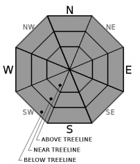
The avalanche danger is LOW for all elevations and aspects throughout the advisory area. Avalanches are unlikely and NORMAL CAUTION is advised. Shallow snowpack hazards exist. Watch for falling rime ice in upper elevation terrain on Mount Shasta.


Avalanche Problem 1: Normal Caution
-
Character ?

-
Aspect/Elevation ?
-
Likelihood ?CertainVery LikelyLikelyPossible
 Unlikely
 -
Size ?HistoricVery LargeLargeSmall

NORMAL CAUTION means:
- Always watch for isolated slabs.
- Ski and ride one at a time in avalanche terrain.
- Don't regroup in run out zones.
- Basic avalanche rescue skills are essential in avalanche terrain.
Isolated slabs are generally related to wind and terrain. Look for places where small areas of drifting have occurred and firm layers of surface snow overlie softer layers. Often this will occur on the lee side of ridges, in terrain depressions, on convex terrain features and in the lee of isolated bands of trees.
Forecast Discussion
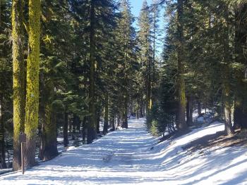
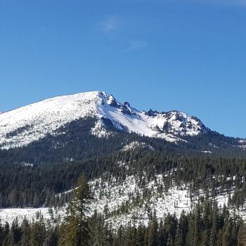
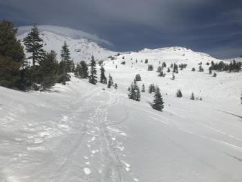
The warm temperatures are taking a toll on the snowpack. A noticeable loss in snow height has occurred in areas below 7,500 ft over the past week. Although it is possible to ski and ride in the Ash Creek Butte area, Mount Shasta, by far, has the most useable snowpack in the advisory area. Castle Lake and Mount Eddy still have very little or not enough snow for winter recreation.
Icefall remains a concern in upper elevation terrain on Mount Shasta. Continue to exercise normal caution in the backcountry. There is always some degree of risk, and even traveling on a LOW danger day is not a 100% guarantee of safety.
Recent Observations
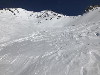
Northwest winds were strong yesterday near and above treeline with gusts over 50 mph at the Grey Butte weather station. Overnight temperatures dropped near or to just below freezing at most stations. A ride to Ash Creek Butte and the Brewer Creek trailhead revealed very low snow coverage below 6,500 ft. Above, 1-3 ft of snow with 4-6 in of moist soft snow at the surface made for fun riding. No signs of avalanches or instability were observed. Recent grooming on the roads has helped keep the snow from melting, but bare patches are impossible to avoid. With a 4x4 vehicle, it is possible to drive to the intersection of Military Pass and the Brewer Creek trailhead road.
Weather and Current Conditions
Weather Summary
High pressure will dominate over the west coast bringing warm temperatures across northern California through the weekend. Today will be sunny with highs in the mid 50s. North winds will be strong with gusts up to 35 mph near treeline. Skies will remain clear overnight and winds are expected to die down by tomorrow. The area should remain dry under N-NW flow for the next several days.
24 Hour Weather Station Data @ 6:00 AM
| Weather Station | Temp (°F) | Wind (mi/hr) | Snow (in) | Comments | ||||||||
|---|---|---|---|---|---|---|---|---|---|---|---|---|
| Cur | Min | Max | Avg | Avg | Max Gust | Dir | Depth | New | Water Equivalent | Settlement | ||
| Mt. Shasta City (3540 ft) | 37 | 37 | 42 | 40 | 5 | N | ||||||
| Sand Flat (6750 ft) | 29 | 29 | 46 | 40 | 20 | 0 | 0 | 1 | ||||
| Ski Bowl (7600 ft) | 33.5 | 33 | 48 | 42 | 41 | 0 | 0 | 0 | ||||
| Gray Butte (8000 ft) | 31.5 | 31 | 43 | 38 | 11 | 55 | NNW | |||||
| Castle Lake (5870 ft) | 35.5 | 34 | 44.5 | 38.5 | 8.5 | 0 | 0 | |||||
| Mount Eddy (6509 ft) | 33 | 32 | 43.5 | 37.5 | 3 | 14 | SE | 20.5 | 0 | 0 | ||
| Ash Creek Bowl (7250 ft) | station down | |||||||||||
| Ash Creek Ridge (7895 ft) | station down |
Two Day Mountain Weather Forecast
Produced in partnership with the Medford NWS
| For 7000 ft to 9000 ft | |||
|---|---|---|---|
|
Tuesday (4 a.m. to 10 p.m.) |
Tuesday Night (10 p.m. to 4 a.m.) |
Wednesday (4 a.m. to 10 p.m.) |
|
| Weather | Sunny and breezy | Clear | Sunny |
| Temperature (°F) | 48 | 35 | 56 |
| Wind (mi/hr) | North 15-20 mi/hr | Northeast 5-10 mi/hr | East/Northeast 5-10 mi/hr |
| Precipitation SWE / Snowfall (in) | / 0 | / 0 | / 0 |
| For 9000 ft to 11000 ft | |||
| Tuesday | Tuesday Night | Wednesday | |
| Weather | Sunny and windy | Clear | Sunny and windy |
| Temperature (°F) | 31 | 31 | 33 |
| Wind (mi/hr) | North 30-40 mi/hr | North 0 | Northeast 15-20 mi/hr |
| Precipitation SWE / Snowfall (in) | / 0 | / 0 | / 0 |
Season Precipitation for Mount Shasta City
| Period | Measured (in) | Normal (in) | Percent of Normal (%) |
|---|---|---|---|
| From Oct 1, 2025 (the wet season) | 10.11 | 22.75 | 44 |
| Month to Date (since Jun 1, 2026) | 0.00 | 0.48 | 0 |
| Year to Date (since Jan 1, 2026) | 4.28 | 7.54 | 57 |

