

You are here
Avalanche Advisory for 2018-02-27 06:40
- EXPIRED ON February 28, 2018 @ 6:40 amPublished on February 27, 2018 @ 6:40 am
- Issued by Andrew Kiefer - Mt Shasta Avalanche Center
Bottom Line
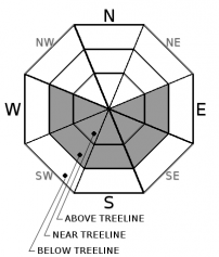
The avalanche danger is MODERATE near and above treeline where fresh wind slabs 1-2 feet thick have formed on W-SW-S-SE-E aspects. Wind slabs will grow in size and distribution today with continued northerly winds. Human triggered wind slab avalanches are possible while natural avalanches are unlikely. Below treeline, the avalanche danger is LOW.


Avalanche Problem 1: Wind Slab
-
Character ?

-
Aspect/Elevation ?
-
Likelihood ?CertainVery LikelyLikelyPossible
 Unlikely
 -
Size ?HistoricVery LargeLargeSmall

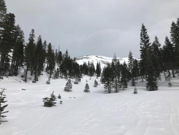
New snow and northerly winds have created fresh wind slabs near and above treeline on W-SW-S-SE-E aspects. Wind slabs 1-2 ft thick could be human triggered on leeward slopes and terrain features 35 degrees and steeper. Watch for blowing snow, cornices, textured snow surfaces and drifts of snow as evidence of recent wind loading. Be especially careful of convex slopes, gullies and terrain depressions between 7,500-9,000 ft where previous wind loading has occurred. Plenty of low-density snow is available for transport and active wind loading is expected today.
Forecast Discussion
The recent storm produced more snow than anticipated and added a much-needed refresh to the backcountry. With storm totals of 4-8 inches of snow and continued northerly winds, wind slabs are the primary avalanche concern and will grow in size and distribution today. Shallow snowpack hazards still exist below treeline and are now just barely covered by the fresh snow. A major winter storm will begin tomorrow, bringing changing conditions in the backcountry and rising avalanche danger in the coming days.
Recent Observations
Snowfall continued into the afternoon yesterday with an additional 3-5 inches of low-density snow accumulating throughout the advisory area. Totals from yesterday’s storm range from 4-8 inches. Winds were calm out of the W yesterday morning, but became strong and shifted to the N/NE in the afternoon and overnight with a max wind gust over 60 mph at Grey Butte.
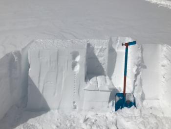
Precipitation intensity up to 2 inches an hour was observed yesterday between 11am-1pm during a tour to 8,500 ft in Avalanche Gulch. Visibility was limited above treeline. No avalanches, shooting cracks or whumphs were observed. Very little wind loading had occurred before 2 pm yesterday. The new snow was evenly distributed throughout the terrain and unconsolidated, not showing any slab properties. No recent wind slabs were seen, but the winds had not picked up yet. Previously wind loaded areas were encountered with isolated winds slabs up to 2 ft thick on SE aspects near and above treeline.
Weather and Current Conditions
Weather Summary
Today will be sunny with strong and gusty north/northeast winds. High temperatures will reach the low 30s. Tonight will be clear with increasing clouds by tomorrow morning. A deep trough of low pressure will impact northern California Wednesday night through Friday. Hurricane force winds out of the southwest are expected above treeline. Precipitation should begin after 10 am on Wednesday. The bulk of snow should come Wednesday night and during the day on Thursday. Over 2 inches of water and 2-3 feet of snow are expected by this weekend with snow levels dropping to 2,000-3,000 ft.
24 Hour Weather Station Data @ 6:00 AM
| Weather Station | Temp (°F) | Wind (mi/hr) | Snow (in) | Comments | ||||||||
|---|---|---|---|---|---|---|---|---|---|---|---|---|
| Cur | Min | Max | Avg | Avg | Max Gust | Dir | Depth | New | Water Equivalent | Settlement | ||
| Mt. Shasta City (3540 ft) | 23 | 23 | 35 | 29.5 | 7 | NNW | ||||||
| Sand Flat (6750 ft) | station down | |||||||||||
| Ski Bowl (7600 ft) | 7.5 | 6.5 | 21 | 14 | 44 | 3 | 0.2 | 3 | ||||
| Gray Butte (8000 ft) | 14 | 9 | 16.5 | 13.5 | 13 | 63 | N | |||||
| Castle Lake (5870 ft) | 12 | 12 | 23 | 18 | 11 | 2 | 1 | |||||
| Mount Eddy (6509 ft) | 10 | 9 | 20.5 | 14.5 | 3 | 13 | SSE | 32 | 5 | 2 | ||
| Ash Creek Bowl (7250 ft) | station down | |||||||||||
| Ash Creek Ridge (7895 ft) | station down |
Two Day Mountain Weather Forecast
Produced in partnership with the Medford NWS
| For 7000 ft to 9000 ft | |||
|---|---|---|---|
|
Tuesday (4 a.m. to 10 p.m.) |
Tuesday Night (10 p.m. to 4 a.m.) |
Wednesday (4 a.m. to 10 p.m.) |
|
| Weather | Sunny. Wind chill values as low as -10. | Partly cloudy with a 10 percent chance of snow after 4am. | Snow, mainly after 4pm. Chance of precipitation 80%. |
| Temperature (°F) | 29 | 20 | 29 |
| Wind (mi/hr) | N 10-15 mi/hr | N/NW 5-10 mi/hr | S 5-10 mi/hr |
| Precipitation SWE / Snowfall (in) | / 0 | / 0 | / 2-4 |
| For 9000 ft to 11000 ft | |||
| Tuesday | Tuesday Night | Wednesday | |
| Weather | Sunny. Wind chill values as low as -29. | A 10 percent chance of snow after 4am. Wind chill values as low as -9. | Snow, mainly after 4pm. Chance of precipitation 80 percent. Wind chill values as low as -23. |
| Temperature (°F) | 16 | 14 | 15 |
| Wind (mi/hr) | N/NE 40-50 mi/hr | W/NW 0 | W/SW 20-30 mi/hr |
| Precipitation SWE / Snowfall (in) | / 0 | / 0 | / 2-4 |
Season Precipitation for Mount Shasta City
| Period | Measured (in) | Normal (in) | Percent of Normal (%) |
|---|---|---|---|
| From Oct 1, 2025 (the wet season) | 10.49 | 28.96 | 36 |
| Month to Date (since Jun 1, 2026) | 0.38 | 6.69 | 6 |
| Year to Date (since Jan 1, 2026) | 4.66 | 13.75 | 34 |

