

You are here
Avalanche Advisory for 2018-12-02 06:30
- EXPIRED ON December 3, 2018 @ 6:30 amPublished on December 2, 2018 @ 6:30 am
- Issued by Aaron Beverly - Mount Shasta Avalanche Center
Bottom Line
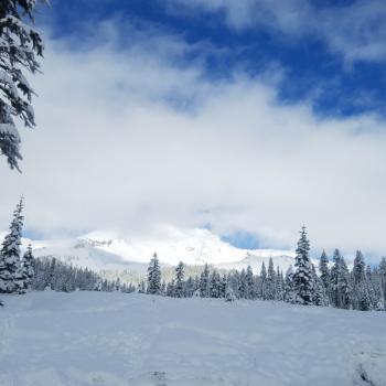
Avalanche danger is CONSIDERABLE near and above treeline due to the formation of wind slabs. Wind slabs will be touchy to trigger and it will be best to avoid leeward slopes today. Small loose-dry avalanches may be triggered below and near treeline in wind protected areas where slopes are greater than 35 degrees. Be prepared for cold temperatures.


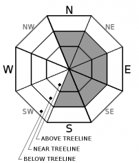
Avalanche Problem 1: Wind Slab
-
Character ?

-
Aspect/Elevation ?
-
Likelihood ?CertainVery LikelyLikelyPossible
 Unlikely
 -
Size ?HistoricVery LargeLargeSmall

Be very mindful of the wind slab problem today. Wind slabs will mostly be seen on SE-E-NE aspects but mountain winds are variable so look for them wherever there is evidence of wind loading. Small wind slab avalanches were observed near treeline yesterday on Gray Butte. Moderate to strong NW winds coupled with new snow will have caused these wind slabs to grow late into last night.
Evaluate snow and terrain carefully. Avoid wind slabs by traveling in windward areas where snow surfaces have been eroded. Avoid slopes greater than 35 degrees where wind loading has occurred. Evaluate conditions as you travel in safe terrain by looking for signs of the wind slab problem:
- Smooth rounded wind pillows
- Hollow sounding snow
- Harder snow atop softer snow
- Shooting cracks
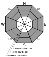
Avalanche Problem 2: Loose Dry
-
Character ?

-
Aspect/Elevation ?
-
Likelihood ?CertainVery LikelyLikelyPossible
Unlikely
-
Size ?HistoricVery LargeLargeSmall
With 5-6 inches of new dry snow received yesterday, keep an eye out for the loose-dry problem on slopes greater than 35 degrees. This type of avalanche starts at a point and entrains snow as it moves downhill. These "sluffs" are usually harmless but can catch an unaware skier and carry them into or over a terrain trap or down a long slope.
Loose-dry avalanches could be encountered below and near treeline in areas protected by the wind.
Forecast Discussion
Temperatures will remain very cold the next two days. If venturing out into the backcountry, bring appropriate clothing to stay warm!
Recent Observations
A series of winter storms beginning on Thanksgiving (November 22, 2018) has brought 50 inches of snow above 7000 ft. Current height of snow (HN) at the Old Ski Bowl weather station is 42 inches.
Yesterday brought 5-6 inches of light low density snow to the forecast area. Moderate to strong NW winds continued to transport snow throughout the day and night until 10 p.m. Early season obstacles are mostly covered.
Three small avalanches were observed on Gray Butte. Two were wind slab avalanches with 10 inch crowns, about 20 ft wide and 90 ft in length, one natural, and one skier-triggered. See observation below for more details.
Weather and Current Conditions
Weather Summary
Expect dry cold conditions to prevail today and tomorrow accompanied by light winds. A weak warm front will bring warmer moist air back late Monday night and Tuesday. A series of low pressure systems in the northern Pacific may bring significant moisture back to the region Friday and early next week.
We are currently 155% of normal for precipitation for December!
24 Hour Weather Station Data @ 5:00 AM
| Weather Station | Temp (°F) | Wind (mi/hr) | Snow (in) | Comments | ||||||||
|---|---|---|---|---|---|---|---|---|---|---|---|---|
| Cur | Min | Max | Avg | Avg | Max Gust | Dir | Depth | New | Water Equivalent | Settlement | ||
| Mt. Shasta City (3540 ft) | 32 | 32 | 45 | 36.5 | 2 | N | ||||||
| Sand Flat (6750 ft) | 17 | 17 | 26 | 22 | 33 | 1 | 0.12 | 1 | ||||
| Ski Bowl (7600 ft) | 13 | 12 | 23.5 | 17.5 | 41.6 | 2.7 | 0.12 | 3.9 | ||||
| Gray Butte (8000 ft) | 14 | 12.5 | 22 | 17 | 19 | 55 | NW | |||||
| Castle Lake (5870 ft) | station down | |||||||||||
| Mount Eddy (6509 ft) | 19.5 | 19 | 26 | 22 | 2 | 15 | SSE | 36.1 | 3.4 | 3.5 | ||
| Ash Creek Bowl (7250 ft) | station down | |||||||||||
| Ash Creek Ridge (7895 ft) | station down |
Two Day Mountain Weather Forecast
Produced in partnership with the Medford NWS
| For 7000 ft to 9000 ft | |||
|---|---|---|---|
|
Sunday (4 a.m. to 10 p.m.) |
Sunday Night (10 p.m. to 4 a.m.) |
Monday (4 a.m. to 10 p.m.) |
|
| Weather | A 20 percent chance of snow showers before 10 a.m. Mostly sunny. | Mostly clear. | A 30 percent chance of snow after 4 p.m. Mostly sunny. |
| Temperature (°F) | 29 | 17 | 30 |
| Wind (mi/hr) | NW 5 | NE 3 | SE 3 |
| Precipitation SWE / Snowfall (in) | / 0 | / 0 | / 0 |
| For 9000 ft to 11000 ft | |||
| Sunday | Sunday Night | Monday | |
| Weather | A 20 percent chance of snow showers before 10 a.m. Mostly sunny and cold. Wind chill values as low as -13. Windy. | A 60 percent chance of snow showers, mainly before 11pm. Mostly cloudy. Windy. Wind chill values as low as -19. | Mostly sunny and cold. Windy. |
| Temperature (°F) | 11 | 11 | 23 |
| Wind (mi/hr) | NW 15 | NW 0 | W 8 |
| Precipitation SWE / Snowfall (in) | / 0 | / 0 | / 0 |
Season Precipitation for Mount Shasta City
| Period | Measured (in) | Normal (in) | Percent of Normal (%) |
|---|---|---|---|
| From Oct 1, 2025 (the wet season) | 5.07 | 7.58 | 67 |
| Month to Date (since Jun 1, 2026) | 0.34 | 0.22 | 155 |
| Year to Date (since Jan 1, 2026) | 20.35 | 35.58 | 57 |

