

You are here
Avalanche Advisory for 2018-12-07 06:13
- EXPIRED ON December 8, 2018 @ 6:13 amPublished on December 7, 2018 @ 6:13 am
- Issued by Nick Meyers - Shasta-Trinity National Forest
Bottom Line
The avalanche danger is LOW at all elevations and aspects. Exercise normal caution. Shallow buried rocks and trees exist everywhere.


Avalanche Problem 1: Normal Caution
-
Character ?

-
Aspect/Elevation ?
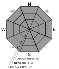
-
Likelihood ?CertainVery LikelyLikelyPossible
 Unlikely
Generally safe avalanche conditions exist in the backcountry. Both natural and human triggered avalanches are unlikely. Exercise NORMAL CAUTION and watch for the odd wind slab(s) on leeward slopes. Wind pillows, hollow sounding snow, shooting cracks, and harder snow atop softer snow are signs that a wind slab may be nearby.
Forecast Discussion
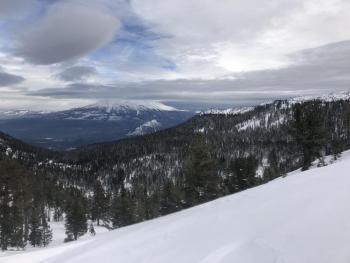
This week has brought several days of gorgeous weather. Full sun, crisp temperatures and soft snow surfaces have been daily delights enjoyed by many. Hopefully the virtual landmine of rocks lurking havn't stopped the show for any. While our early season winter snowpack is set in place, more snow is necessary to seal the deal. Avalanche danger is on hold. Climbers should be cautious for slide for life conditions up higher as well as rockfall. Many ridgelines and classic avalanche starting zones are scoured and exposed. With a little bit of early season caution, there is still plenty to enjoy here in Northern California.
Recent Observations
- Old Ski Bowl weather station tipping/precipitation bucket is back up and operating. Any precipitation recorded from this week can be disregarded.
- Castle Lake weather station is still down. We are having radio communication trouble and working on fixnig the problem ASAP.
- Snow depths at various locations:
- Old Ski Bowl (Mount Shastsa) - 8,500 feet - 35 inches average with drifts 40 to 50 inches, wind textured with soft snow surfaces. Ridgelines scoured to rock.
- Castle Lake - 10 to 15 inches - needs more snow for reasonable winter recreation. The lake is frozen and NOT supportable. An active bear has been observed on Left Peak recently.
- Eddy Mountains - 25-30 inches - decent coverage. Vehicle access 5.2 miles up Parks Creek road from Stewart Mineral Springs.
- No new avalanches observed
- Snow stability very good
- Small surface hoar snow crystals observed in isolated areas near and above treeline on shady aspects.
- A virtual landmine of rocks and other shallow buried objects exist
- Sand Flat winter cross-country ski trails are open with 27 inches of snow on the ground.
Weather and Current Conditions
Weather Summary
Today will be similar to yesterday, albeit we'll see increasing cloud cover as the day progresses. The first in a series of fronts will move through the area this evening. Compared to future expected fronts, this one is releatively weak and will wash out as it moves inland. Little snow accumulation is expected. We will get a break in the action Saturday and then see the next system approach the area late Saturday night into Sunday morning. Showers will continue into Monday. The extended forecast is wet, although precipitation will not be continuous. Snow levels should remain fairly low, keeping our winter stomping grounds out of the rain. Each wave will bring small amounts of rain, snow, wind and overall...wintery weather!
Curious about the status of EL NINO? Click HERE
24 Hour Weather Station Data @ 4:00 AM
| Weather Station | Temp (°F) | Wind (mi/hr) | Snow (in) | Comments | ||||||||
|---|---|---|---|---|---|---|---|---|---|---|---|---|
| Cur | Min | Max | Avg | Avg | Max Gust | Dir | Depth | New | Water Equivalent | Settlement | ||
| Mt. Shasta City (3540 ft) | 26 | 26 | 45 | 35 | 0 | N | ||||||
| Sand Flat (6750 ft) | 22 | 20 | 34 | 26 | 27 | 0 | 0 | 3 | ||||
| Ski Bowl (7600 ft) | 26 | 26 | 38.5 | 30.5 | 34.7 | 0 | 0 | 1.9 | ||||
| Gray Butte (8000 ft) | 27 | 27 | 38.5 | 31 | 5 | 18 | E | |||||
| Castle Lake (5870 ft) | 0 | 0 | 0 | 0 | 0 | 0 | 0 | station down | ||||
| Mount Eddy (6509 ft) | 23 | 22 | 38 | 27.5 | 2 | 5 | WSW | 227.8 | 0 | 19.5 | ||
| Ash Creek Bowl (7250 ft) | station down | |||||||||||
| Ash Creek Ridge (7895 ft) | station down |
Two Day Mountain Weather Forecast
Produced in partnership with the Medford NWS
| For 7000 ft to 9000 ft | |||
|---|---|---|---|
|
Friday (4 a.m. to 10 p.m.) |
Friday Night (10 p.m. to 4 a.m.) |
Saturday (4 a.m. to 10 p.m.) |
|
| Weather | Mostly sunny | Partly cloudy with a 30% chance of snow, mainly between 10pm and 4am. Little to no snow accumulation expected | Mostly cloudy, a 20% chance of snow before 10am. Little to no snow accumulations expected |
| Temperature (°F) | 36 | 26 | 37 |
| Wind (mi/hr) | S/SE 5-10 | S/SE 10-15 | S/SE 5-10 |
| Precipitation SWE / Snowfall (in) | / 0 | / < .5 | / 0 |
| For 9000 ft to 11000 ft | |||
| Friday | Friday Night | Saturday | |
| Weather | Mostly sunny | Partly cloudy, a 30% chance of snow, mainly between 10pm and 4am, windy, snow accumulation less than a half inch possible. | Mostly cloudy, breezy, a 20% chance of snow before 10am. |
| Temperature (°F) | 27 | 22 | 28 |
| Wind (mi/hr) | W/SW 10-15 | W 0 | SW 10-15 |
| Precipitation SWE / Snowfall (in) | / 0 | / < .5 | / 0 |
Season Precipitation for Mount Shasta City
| Period | Measured (in) | Normal (in) | Percent of Normal (%) |
|---|---|---|---|
| From Oct 1, 2025 (the wet season) | 5.08 | 8.73 | 58 |
| Month to Date (since Jun 1, 2026) | 0.35 | 1.37 | 26 |
| Year to Date (since Jan 1, 2026) | 20.36 | 36.73 | 55 |

