

You are here
Avalanche Advisory for 2018-12-09 06:34
- EXPIRED ON December 10, 2018 @ 6:34 amPublished on December 9, 2018 @ 6:34 am
- Issued by Nick Meyers - Shasta-Trinity National Forest
Bottom Line
The avalanche danger will rise to MODERATE late today and tonight near and above treeline as a new storm blows in. Increasing southwest winds with a few inches of new snow will create fresh wind slabs in leeward terrain.
LOW danger exists below treeline.


Avalanche Problem 1: Wind Slab
-
Character ?

-
Aspect/Elevation ?
-
Likelihood ?CertainVery LikelyLikelyPossible
 Unlikely
 -
Size ?HistoricVery LargeLargeSmall

Southwest winds will be strong enough to move new snow. Wind slabs will be small to medium in size and are likely to be most sensitive to trigger late tonight and early tomorrow. Look for signs of newly wind drifted snow in the form of wind pillows, wind textured snow surfaces and cornice formation. Keep in mind that a buried surface hoar weak layer may lurk in isolated areas and could fail on lower angle slopes. If uncertainty remains, opt for more wind protected terrain. Simply avoiding all wind affected areas is an easy way to manage this problem.
Forecast Discussion
Avalanche danger will rise and fall several times over the course of the week and periods of new snow and wind move into the area. Some classic avalanche paths still have exposed rocks and will need more snow to pose a threat. Others are fair game. Larger avalanches are unlikely in the near future, but be on the look out for smaller, isolated, wind loaded areas where one might be able to kick something off; something certainly big enough to bury a person.
Recent Observations
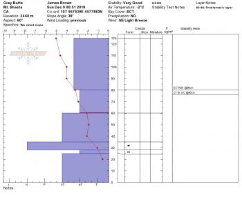
We've had a slight, albiet steady increase in temperatures over the week and the past few days the snowpack has taken a hit. Variable snow surfaces is the soup de jour, including sun crusts, glop and a little bit of soft, semi-fresh feeling snow in protected, shady areas. Overall snow stability is very good with no notable weaknesses within our base snowpack. The high pressure that has been lingering for the last few days has brought beautiful sunny skies and chilly temperatures and gifted us with an abundant amount of surface hoar below, near and above treeline. Most of this surface hoar will or already has been destroyed before becoming buried by our next storm. That said, it will be good to keep this potential weak layer in mind as new snow falls. Continue to use caution for shallow buried hazards.
Snow depths at various locations:
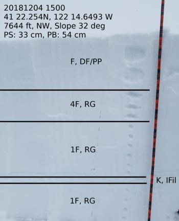
- Old Ski Bowl - 35 inches average with drifts 40 to 50 inches, wind textured with soft snow surfaces. Ridge lines scoured to rock.
- Castle Lake - 10 to 15 inches; needs more snow for reasonable winter recreation. The lake is not fully frozen and NOT supportable. An active bear has been observed on Left Peak.
- Eddy Mountains - 25-30 inches; decent coverage. Vehicle access 5.2 miles up Parks Creek road from Stewart Mineral Springs.
Weather and Current Conditions
Weather Summary
Several chapters of inclement weather will deliver periods of wind, rain and snow over the next 10 days. A breif rundown for the precipitation timing: later today into tonight, Tuesday night, Friday/Friday night and Saturday night through Sunday next week. Snow levels will be around 4,500 feet today, 4,200 feet tonight and 4,100 feet tomorrow with moderate amounts of precipitation, .17" water by 10am Monday. Today will be a breezy one above treeline on Mount Shasta. We can't quite promise a white Christmas yet, but it's looking hopeful.
24 Hour Weather Station Data @ 5:00 AM
| Weather Station | Temp (°F) | Wind (mi/hr) | Snow (in) | Comments | ||||||||
|---|---|---|---|---|---|---|---|---|---|---|---|---|
| Cur | Min | Max | Avg | Avg | Max Gust | Dir | Depth | New | Water Equivalent | Settlement | ||
| Mt. Shasta City (3540 ft) | 36 | 29 | 50 | 38 | 0 | N | ||||||
| Sand Flat (6750 ft) | 32 | 27 | 36 | 31 | 25 | 0 | 0 | 1 | ||||
| Ski Bowl (7600 ft) | 31 | 26 | 34 | 30.5 | 35 | 0 | 0 | 0 | ||||
| Gray Butte (8000 ft) | 29 | 26.5 | 32 | 29.5 | 8 | 25 | WNW | |||||
| Castle Lake (5870 ft) | 0 | 0 | 0 | 0 | 0 | 0 | 0 | station down | ||||
| Mount Eddy (6509 ft) | 30.5 | 27.5 | 35 | 31.5 | 1 | 10 | WSW | 27.5 | 0 | 0 | ||
| Ash Creek Bowl (7250 ft) | station down | |||||||||||
| Ash Creek Ridge (7895 ft) | station down |
Two Day Mountain Weather Forecast
Produced in partnership with the Medford NWS
| For 7000 ft to 9000 ft | |||
|---|---|---|---|
|
Sunday (4 a.m. to 10 p.m.) |
Sunday Night (10 p.m. to 4 a.m.) |
Monday (4 a.m. to 10 p.m.) |
|
| Weather | A 40% chance of snow after 10am. Increasing clouds, breezy. | Snow showers, mainly before 4am. | A 30% chance of snow showers before 10am, partly sunny. |
| Temperature (°F) | 35 | 27 | 31 |
| Wind (mi/hr) | S/SE 10-15 | S/SE 5-10 | N/NW 0-5 |
| Precipitation SWE / Snowfall (in) | / < 1 | / 1-3 | / < .5 |
| For 9000 ft to 11000 ft | |||
| Sunday | Sunday Night | Monday | |
| Weather | A 40 percent chance of snow after 10am, increasing clouds, temperatures falling, windy. | Snow showers, mainly before 4am, windy. | A 40 percent chance of snow showers, mainly before 10am, partly sunny, windy. |
| Temperature (°F) | 30 | 13 | 17 |
| Wind (mi/hr) | SW 30-40 | SW 1-2 | NW 10-15 |
| Precipitation SWE / Snowfall (in) | / 1-2 | / 3-5 | / < .5 |
Season Precipitation for Mount Shasta City
| Period | Measured (in) | Normal (in) | Percent of Normal (%) |
|---|---|---|---|
| From Oct 1, 2025 (the wet season) | 5.08 | 9.21 | 55 |
| Month to Date (since Jun 1, 2026) | 0.35 | 1.85 | 19 |
| Year to Date (since Jan 1, 2026) | 20.36 | 37.21 | 55 |

