

You are here
Avalanche Advisory for 2018-12-11 06:30
- EXPIRED ON December 12, 2018 @ 6:30 amPublished on December 11, 2018 @ 6:30 am
- Issued by Aaron Beverly - Mount Shasta Avalanche Center
Bottom Line
The avalanche danger is LOW at all elevations. LOW does not mean NO avalanche danger. Look out for small isolated wind slabs on leeward slopes greater than 35 degrees. Expect blustery conditions near and above treeline late today.


Avalanche Problem 1: Wind Slab
-
Character ?

-
Aspect/Elevation ?
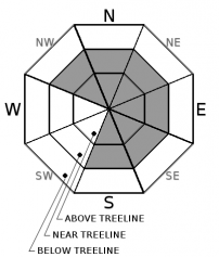
-
Likelihood ?CertainVery LikelyLikelyPossible
 Unlikely
 -
Size ?HistoricVery LargeLargeSmall

Small cornices and wind pillows were seen yesterday but these were unreactive. A bit of old and new snow accompanied by strong winds late tonight might contribute to the formation of small wind slabs, but these are unlikely to be of much concern. Nevertheless, it is a good idea to keep an eye out for them. Signs of this problem are wind pillows, wind textured snow surfaces, and cornice formation. If uncertainty exists, travel in more wind protected terrain.
Forecast Discussion
Natural and human triggered avalanches are unlikely, but LOW avalanche danger still means you should watch for unstable snow on isolated terrain features or in extreme terrain.
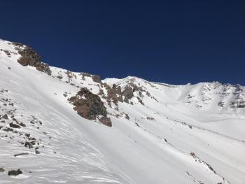
Rocks litter the snow surface near and above treeline. These are mostly easy to spot, but a few still lurk beneath waiting to knick your skis on a deep carve.
The Mount Shasta Ski Park opens tomorrow. Come out and partake in the winter fun!
Recent Observations
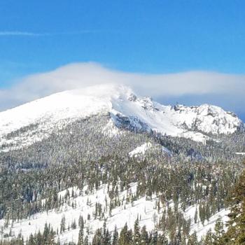
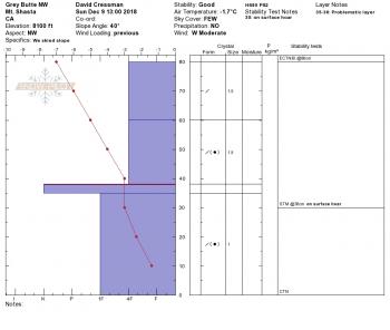
Sliders and riders discovered a fun, fast and stable snow pack yesterday near Powder Bowl and Gray Butte, both above and below treeline. No significant signs of a wind slab problem were encountered. Winds were so calm, you could light a candle. The 1-2 inches of new snow filled in some of the wind affected areas above treeline creating smooth creamy snow surfaces. Snow below treeline was moist but easy to ride. See the observation for details.
Weather and Current Conditions
Weather Summary
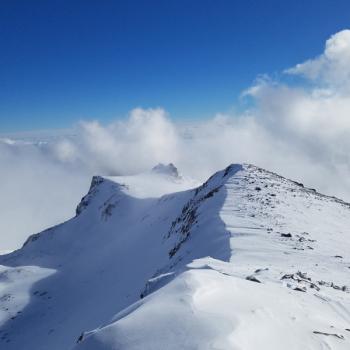
A frontal system moves in later today that will bring warmer air, strong winds, and a meager amount of snow above 6200 ft. Things look to kick in late tonight. Hang on if you happen to find yourself above treeline.
This weekend looks more promising for snow accumulation.
24 Hour Weather Station Data @ 4:00 AM
| Weather Station | Temp (°F) | Wind (mi/hr) | Snow (in) | Comments | ||||||||
|---|---|---|---|---|---|---|---|---|---|---|---|---|
| Cur | Min | Max | Avg | Avg | Max Gust | Dir | Depth | New | Water Equivalent | Settlement | ||
| Mt. Shasta City (3540 ft) | 25 | 25 | 45 | 36.5 | 1 | N | ||||||
| Sand Flat (6750 ft) | 18 | 17 | 32 | 24 | 27 | 1 | 0 | 2 | ||||
| Ski Bowl (7600 ft) | 28 | 21 | 32 | 25.5 | 34.5 | 1 | 0 | 2.2 | ||||
| Gray Butte (8000 ft) | 30.5 | 21 | 30.5 | 26 | 4 | 25 | ESE | |||||
| Castle Lake (5870 ft) | station down | |||||||||||
| Mount Eddy (6509 ft) | 33 | 19.5 | 33 | 25.5 | 2 | 8 | WSW | 28.9 | 1 | 1 | ||
| Ash Creek Bowl (7250 ft) | station down | |||||||||||
| Ash Creek Ridge (7895 ft) | station down |
Two Day Mountain Weather Forecast
Produced in partnership with the Medford NWS
| For 7000 ft to 9000 ft | |||
|---|---|---|---|
|
Tuesday (4 a.m. to 10 p.m.) |
Tuesday Night (10 p.m. to 4 a.m.) |
Wednesday (4 a.m. to 10 p.m.) |
|
| Weather | A slight chance of snow before 1 p.m, then rain likely, possibly mixed with snow. Mostly cloudy. Gusty. Chance of precipitation is 60%. Little or no snow accumulation expected. | Rain and snow likely, becoming all snow after 10 p.m. Patchy blowing snow after 4 a.m. Cloudy, then gradually becoming partly cloudy. Windy and gusty. Chance of precipitation is 70%. | Patchy blowing snow before 10 a.m. Mostly sunny. Gusty. |
| Temperature (°F) | 39 | 27 | 37 |
| Wind (mi/hr) | N 10 | W 17 | NW 11 |
| Precipitation SWE / Snowfall (in) | / 0 | / < 0.5 | / 0 |
| For 9000 ft to 11000 ft | |||
| Tuesday | Tuesday Night | Wednesday | |
| Weather | Snow likely, mainly after 4 p.m. Patchy blowing snow. Mostly cloudy. Wind chill values as low as -1. Windy and gusty. Chance of precipitation is 60%. | Snow, mainly before 1 a.m., then snow showers after 1 a.m. Widespread blowing snow. Wind chill values as low as -9. Windy and gusty. Chance of precipitation is 80%. | Widespread blowing snow before 10 a.m. Mostly sunny. Wind chill values as low as -10. Windy and gusty. |
| Temperature (°F) | 30 | 15 | 21 |
| Wind (mi/hr) | W 27 | W < 0.5 | NW 28 |
| Precipitation SWE / Snowfall (in) | / < 0.5 | / 1-2 | / 0 |
Season Precipitation for Mount Shasta City
| Period | Measured (in) | Normal (in) | Percent of Normal (%) |
|---|---|---|---|
| From Oct 1, 2025 (the wet season) | 5.16 | 9.69 | 53 |
| Month to Date (since Jun 1, 2026) | 0.43 | 2.33 | 18 |
| Year to Date (since Jan 1, 2026) | 20.44 | 37.69 | 54 |

