

You are here
Avalanche Advisory for 2018-12-14 05:55
- EXPIRED ON December 15, 2018 @ 5:55 amPublished on December 14, 2018 @ 5:55 am
- Issued by Nick Meyers - Shasta-Trinity National Forest
Bottom Line
Heavy snowfall with strong winds will contribute to increasing avalanche danger late this afternoon and evening. Safe travel through avalanche terrain will require a cautious approach. New wind slabs are possible near and above treeline and the avalanche danger is expected to rise to MODERATE due to the incoming storm. Below treeline, avalanche danger will remain LOW for the day.


Avalanche Problem 1: Wind Slab
-
Character ?

-
Aspect/Elevation ?
-
Likelihood ?CertainVery LikelyLikelyPossible
 Unlikely
 -
Size ?HistoricVery LargeLargeSmall

New wind slabs are likely to develop late this afternoon and this evening. Southerly winds will actively load leeward slopes near and above treeline. There is no clearer sign of unstable snow than recent avalanche activity. Pay attention out there. Look for blowing snow, wind pillows, and/or smooth, round, hollow sounding snow. Be suspicious of any steep slope with recent deposits of wind drifted snow as the storm progresses.
Forecast Discussion
A winter weather advisory is in effect this afternoon, issued by the NWS Medford. Blizzard conditions are expected near and above treeline.
Recent Observations
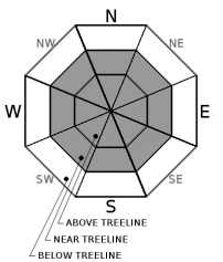
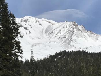
Yesterday hosted variable snow conditions and a dearth of avalanche danger. Mount Shasta is wind blown and scoured with rideable terrain in select areas. It's been two weeks since we've had any sort of natural or human triggered avalanche activity. Exposed rocks pepper the landscape. Unproblematic, hard wind slabs exist in some low angle, leeward morain concavities near and above treeline. Unconsolidated snow is limited to northerly aspects and some protected terrain below treeline. Castle Lake needs more snow for reasonable winter recreation. The Eddy mountains have a decent snowpack, similar to Mount Shasta. All told, another good storm will be great for our winter snowpack.
Above treeline on the south side of Mount Shasta yesterday, December 13, 2018. / Photo: J Koster
Weather and Current Conditions
Weather Summary
Southwest flow aloft has developed, opening the storm door. Upstream weather will move in quickly, pushing a strong front onshore early this afternoon. Precipitation with this front will not be overly significant due to it's fast moving pace. Snow levels should remain near 4,400 feet today, lowering to 3,800 feet tonight and back up to 4,500 feet tomorrow. A winter weather advisory has been issued by the National Weather Service, in effect from 1PM this afternoon to 7PM PST this evening. Very windy conditions can be expected with blizzard conditions on the mountain later today. Showers will continue into Saturday morning, but the remainder of the day should be dry. The weather pattern will remain progressive as the next upstream trough moves in Sunday. Winds will be a concern once again. This front will move a bit slower and with more available moisture. Snow levels will rise to 5,500 feet.
24 Hour Weather Station Data @ 3:00 AM
| Weather Station | Temp (°F) | Wind (mi/hr) | Snow (in) | Comments | ||||||||
|---|---|---|---|---|---|---|---|---|---|---|---|---|
| Cur | Min | Max | Avg | Avg | Max Gust | Dir | Depth | New | Water Equivalent | Settlement | ||
| Mt. Shasta City (3540 ft) | 43 | 23 | 56 | 39 | 1 | N | ||||||
| Sand Flat (6750 ft) | 32 | 22 | 42 | 32 | 26 | 0 | 0 | .5 | ||||
| Ski Bowl (7600 ft) | 29.5 | 29.5 | 44.5 | 36 | 33.7 | 0 | 0 | .5 | ||||
| Gray Butte (8000 ft) | 27.5 | 27.5 | 42.5 | 35 | 9 | 25 | W | |||||
| Castle Lake (5870 ft) | station down | |||||||||||
| Mount Eddy (6509 ft) | 31.5 | 26 | 44 | 35.5 | 2 | 10 | S | 28.8 | 0 | 0.5 | ||
| Ash Creek Bowl (7250 ft) | station down | |||||||||||
| Ash Creek Ridge (7895 ft) | station down |
Two Day Mountain Weather Forecast
Produced in partnership with the Medford NWS
| For 7000 ft to 9000 ft | |||
|---|---|---|---|
|
Friday (4 a.m. to 10 p.m.) |
Friday Night (10 p.m. to 4 a.m.) |
Saturday (4 a.m. to 10 p.m.) |
|
| Weather | Snow, mainly after 10am. Snow could be heavy at times. Windy. Chance of precipitation 100%. | Snow showers, mainly before 10pm. Chance of precipitation 80%. | Snow likely, mainly before 10am. Mostly cloudy. |
| Temperature (°F) | 32 | 25 | 33 |
| Wind (mi/hr) | S 20-25 | SW 25-30 | S 30-35 |
| Precipitation SWE / Snowfall (in) | / 2-6 | / .5-1 | / 1-2 |
| For 9000 ft to 11000 ft | |||
| Friday | Friday Night | Saturday | |
| Weather | Snow, mainly after 10am. Snow could be heavy at times. Windy. Chance of precipitation 100% | Snow showers. Windy. Chance of precipitation 80%. | Snow likely, mainly before 10am. Mostly cloudy. Windy. |
| Temperature (°F) | 27 | 12 | 28 |
| Wind (mi/hr) | S 60-70 | SW 7-11 | S 25-30 |
| Precipitation SWE / Snowfall (in) | / 7-11 | / 1-2 | / 1-3 |
Season Precipitation for Mount Shasta City
| Period | Measured (in) | Normal (in) | Percent of Normal (%) |
|---|---|---|---|
| From Oct 1, 2025 (the wet season) | 5.16 | 10.43 | 49 |
| Month to Date (since Jun 1, 2026) | 0.43 | 3.07 | 14 |
| Year to Date (since Jan 1, 2026) | 20.44 | 38.43 | 53 |

