

You are here
Avalanche Advisory for 2018-12-15 06:26
- EXPIRED ON December 16, 2018 @ 6:26 amPublished on December 15, 2018 @ 6:26 am
- Issued by Nick Meyers - Shasta-Trinity National Forest
Bottom Line
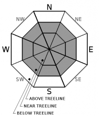
Wind slabs are the primary avalanche problem this weekend. Winds have and will continue to blow out of the S-SW-W and NW, moving new snow onto leeward N-NE-E and SE aspects, near and above treeline. Avalanche danger will fluctuate. Move around the mountains this weekend exercising caution. Have a travel plan for the day, travel through avalanche terrain one at a time, regroup out of avalanche terrain, and practice effective communication within your group.


Avalanche Problem 1: Wind Slab
-
Character ?

-
Aspect/Elevation ?
-
Likelihood ?CertainVery LikelyLikelyPossible
 Unlikely
 -
Size ?HistoricVery LargeLargeSmall

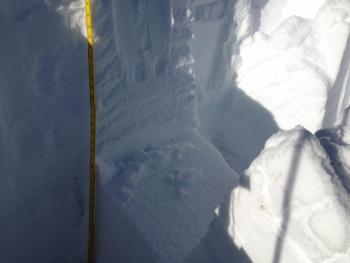
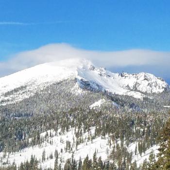
Four inches of new snow with moderate S, SW, W and finally NW winds may have created new, small to medium size wind slabs near and above treeline. Wind slabs are likely to grow in size over the course of the weekend with additional snow and wind. There is no clearer sign of unstable snow than recent avalanche activity. Pay attention out there. Winds slabs are often most sensitive to trigger immediately during or just after storm cycles. Look for blowing snow, wind pillows, shooting cracks and/or smooth, round, hollow sounding snow. Be suspicious of any steep slope with recent deposits of wind drifted snow as the storm progresses. Keep an eye out for any isolated areas where drifting snow is accumulating, forming new and perhaps unstable wind slab(s). Winds will switch back to S/SW today. Weak layers could include old snow/new snow interfaces and/or density changes in the new snow.
Forecast Discussion
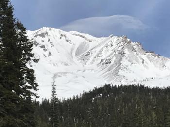
Friday's storm was just a warm up. A short respite today will be followed up with a robust storm arriving late today, tonight and Sunday. Avalanche danger is expected to be at its highest Sunday afternoon into Monday morning for areas mostly near and above treeline. Below treeline, use normal caution.
Recent Observations
If you blinked yesterday, you might have missed the fast paced storm that blew through the area. Precipitation fell from 1300 to 1800 hours, a 5 hour little storm that resulted in about 4 inches (.39" H20) of new snow near treeline on the mountain, and less in the Eddy's and Castle Lake area. Snow surfaces prior to the storm were variable, including many scoured, rocky areas. Temperatures have remained chilly. During the storm, southerly winds dominated and then quickly swung around to WNW. Average wind speed over the last 24 hours was 18 mph. Observations are based on weather station information as we didn't get a chance for a late afternoon storm tour yesterday.
Weather and Current Conditions
Weather Summary
A wet and windy pattern will continue and we should see the effects of the next system later this afternoon/evening. Friday's first wave was a fast paced little number. Sunday's storm will be slower, wetter and a notch weaker with the winds. Snow levels will rise quickly to 5,500 feet tonight and 6,000 feet tomorrow. Upwards of 2 inches of water is expected, which could potentially mean several feet of snow near and above treeline by Monday. Southerly flow will produce strong winds and blizzard conditions on the mountain. Showers will continue into the work week as moist onshore flow persists, and precipitation will never really leave the area before the next front arrives Tuesday.
24 Hour Weather Station Data @ 5:00 AM
| Weather Station | Temp (°F) | Wind (mi/hr) | Snow (in) | Comments | ||||||||
|---|---|---|---|---|---|---|---|---|---|---|---|---|
| Cur | Min | Max | Avg | Avg | Max Gust | Dir | Depth | New | Water Equivalent | Settlement | ||
| Mt. Shasta City (3540 ft) | 31 | 28.5 | 43 | 34.5 | 1 | N | ||||||
| Sand Flat (6750 ft) | 22 | 18 | 33 | 26 | 28 | 2 | 1 | |||||
| Ski Bowl (7600 ft) | 24.5 | 16.5 | 28.5 | 23.5 | 36 | 4 | 0.39 | 1 | ||||
| Gray Butte (8000 ft) | 21.5 | 14.5 | 26.5 | 22 | 18 | 43 | WNW | |||||
| Castle Lake (5870 ft) | station down | |||||||||||
| Mount Eddy (6509 ft) | 27 | 18.5 | 34 | 27 | 2 | 25 | S | 30.1 | 3.1 | 2 | ||
| Ash Creek Bowl (7250 ft) | station down | |||||||||||
| Ash Creek Ridge (7895 ft) | station down |
Two Day Mountain Weather Forecast
Produced in partnership with the Medford NWS
| For 7000 ft to 9000 ft | |||
|---|---|---|---|
|
Saturday (4 a.m. to 10 p.m.) |
Saturday Night (10 p.m. to 4 a.m.) |
Sunday (4 a.m. to 10 p.m.) |
|
| Weather | Rain and snow likely, cloudy, chance of precipitation 60%. Snow level near town, then rising to 5,000 feet | Rain and snow, breezy. Chance of precipitation 80%. Snow level 5,500 feet | Rain and snow, heavy at times, windy. Chance of precipitation 100%. Snow level 6,000 feet. |
| Temperature (°F) | 34 | 31 | 35 |
| Wind (mi/hr) | S 10-15 | S 15-20 | S 20-25 |
| Precipitation SWE / Snowfall (in) | / 0-1 | / 1-2 | / 10-16 |
| For 9000 ft to 11000 ft | |||
| Saturday | Saturday Night | Sunday | |
| Weather | Snow likely, cloudy and windy. Chance of precipitation 60%. | Snow, windy. Chance of precipitation 80%. | Snow, heavy at times, windy. Chance of precipitation 100% |
| Temperature (°F) | 28 | 23 | 24 |
| Wind (mi/hr) | SW 35-40 | SW 1-2 | S 55-65 |
| Precipitation SWE / Snowfall (in) | / 1-2 | / 6-10 | / 22-26 |
Season Precipitation for Mount Shasta City
| Period | Measured (in) | Normal (in) | Percent of Normal (%) |
|---|---|---|---|
| From Oct 1, 2025 (the wet season) | 5.45 | 10.68 | 51 |
| Month to Date (since Jun 1, 2026) | 0.72 | 3.32 | 22 |
| Year to Date (since Jan 1, 2026) | 20.73 | 38.68 | 54 |

