

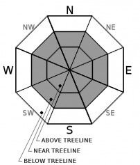
You are here
Avalanche Advisory for 2018-12-16 06:25
- EXPIRED ON December 17, 2018 @ 6:25 amPublished on December 16, 2018 @ 6:25 am
- Issued by Aaron Beverly - Mount Shasta Avalanche Center
Bottom Line
Avalanche danger is CONSIDERABLE. Signifcant snow accumulation and strong winds will cause potentially thick wind slabs to form near and above treeline. Careful snowpack evaluation, cautious route-finding and conservative decision making will be essential today.


Avalanche Problem 1: Wind Slab
-
Character ?

-
Aspect/Elevation ?
-
Likelihood ?CertainVery LikelyLikelyPossible
 Unlikely
 -
Size ?HistoricVery LargeLargeSmall

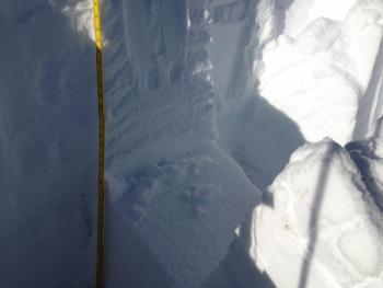
If you dare to venture out in the rain, snow, and wind, wind slabs will be a major concern. With significant snow and wind expected today, look for potentially thick wind slabs above treeline on all aspects. Near and below treeline elevations have received mostly rain over the last 24 hours and will continue to do so, but snow levels will drop by tonight. Wind slabs could grow to several feet thick over the next couple of days.
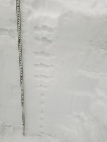
There is no clearer sign of unstable snow than recent avalanche activity. This is a day to pay attention. Winds slabs are often most sensitive to trigger immediately during or just after storm cycles. Look for blowing snow, wind pillows, shooting cracks and/or smooth, round, hollow sounding snow. Be suspicious of any steep slope with recent deposits of wind drifted snow. Weak layers could include old snow/new snow interfaces and/or density changes in the new snow.
Forecast Discussion
CONSIDERABLE avalanche danger means careful snowpack evaluation, cautious route-finding and conservative decision making are essential today. Natural avalanches are possible and human triggered avalanches are likely. You may encounter small avalanches in many areas, large avalanches in specific areas, or very large avalanches in isolated areas.
Recent Observations
Over 3 inches of new snow fell yesterday at Bunny Flat followed by rain that settled the snowpack by over 2 inches at the Old Ski Bowl. Despite seemingly cold weather and low snow levels, most found rainy wet conditions up to 8000 ft. Winds were southerly averaging 13 mi/hr and gusting up to 31. About 0.6 inches of water was recorded.
Weather and Current Conditions
Weather Summary
Hang on for this one. Blizzard conditions are expected above 8000 ft today and tonight. Over 3 inches of water is hanging around in the atmosphere destined to fall by Tuesday morning most of which is coming today. Unfortunately snow levels are high: 6800 ft today then dropping to 5600 ft tonight and 4500 ft tomorrow. Winds are going to howl.
24 Hour Weather Station Data @ 4:00 AM
| Weather Station | Temp (°F) | Wind (mi/hr) | Snow (in) | Comments | ||||||||
|---|---|---|---|---|---|---|---|---|---|---|---|---|
| Cur | Min | Max | Avg | Avg | Max Gust | Dir | Depth | New | Water Equivalent | Settlement | ||
| Mt. Shasta City (3540 ft) | 41 | 32 | 43 | 40 | 3 | |||||||
| Sand Flat (6750 ft) | 32 | 22 | 33 | 32 | 27 | 1 | 0 | 1 | ||||
| Ski Bowl (7600 ft) | 31 | 25 | 31.5 | 30 | 34 | 0 | 0.63 | 2 | ||||
| Gray Butte (8000 ft) | 29 | 23 | 30 | 28 | 13 | 31 | S | |||||
| Castle Lake (5870 ft) | station down | |||||||||||
| Mount Eddy (6509 ft) | 33.5 | 29 | 34 | 32 | 3 | 17 | SSW | 28.4 | 0.7 | 1.5 | ||
| Ash Creek Bowl (7250 ft) | station down | |||||||||||
| Ash Creek Ridge (7895 ft) | station down |
Two Day Mountain Weather Forecast
Produced in partnership with the Medford NWS
| For 7000 ft to 9000 ft | |||
|---|---|---|---|
|
Sunday (4 a.m. to 10 p.m.) |
Sunday Night (10 p.m. to 4 a.m.) |
Monday (4 a.m. to 10 p.m.) |
|
| Weather | Rain and snow. The rain and snow could be heavy at times. Windy and gusty. Chance of precipitation is 100%. | Snow, mainly before 10 p.m., then snow showers likely after 4 a.m. Breezy and gusty. Chance of precipitation is 100%. | Snow showers likely before 10 a.m., then snow likely after 10 a.m. Mostly cloudy. Chance of precipitation is 60%. |
| Temperature (°F) | 37 | 26 | 33 |
| Wind (mi/hr) | S 27 | SW 17 | S 9 |
| Precipitation SWE / Snowfall (in) | / 10-14 | / 1-3 | / < 1 |
| For 9000 ft to 11000 ft | |||
| Sunday | Sunday Night | Monday | |
| Weather | Snow. The snow could be heavy at times. Low wind chill values. Windy and gusty. Chance of precipitation is 100%. | Snow, mainly before 4 a.m., then snow showers likely after 4 a.m. Low wind chill values. Windy and gusty. Chance of precipitation is 100%. | Snow showers likely before 10 a.m., then snow likely after 10 a.m. Mostly cloudy. Low wind chill values. Windy and gusty. Chance of precipitation is 60%. |
| Temperature (°F) | 29 | 16 | 28 |
| Wind (mi/hr) | S 73 | SW 25-31 | SW 27 |
| Precipitation SWE / Snowfall (in) | / 25-31 | / 3-7 | / 1 |
Season Precipitation for Mount Shasta City
| Period | Measured (in) | Normal (in) | Percent of Normal (%) |
|---|---|---|---|
| From Oct 1, 2025 (the wet season) | 5.90 | 10.94 | 54 |
| Month to Date (since Jun 1, 2026) | 1.17 | 3.58 | 33 |
| Year to Date (since Jan 1, 2026) | 21.18 | 38.94 | 54 |

