

You are here
Avalanche Forecast for 2018-12-19 06:00
- EXPIRED ON December 20, 2018 @ 6:00 amPublished on December 19, 2018 @ 6:00 am
- Issued by Aaron Beverly - Mount Shasta Avalanche Center
Bottom Line
The avalanche danger is MODERATE near and above treeline. Blowing snow may have created new wind slabs. Evaluate terrain carefully as you travel and exercise caution if traveling near leeward slopes greater than 35 degrees. Avalanche danger is LOW below treeline.


Avalanche Problem 1: Wind Slab
-
Character ?

-
Aspect/Elevation ?
-
Likelihood ?CertainVery LikelyLikelyPossible
 Unlikely
 -
Size ?HistoricVery LargeLargeSmall

Though no signs of instability or a wind slab problem were observed yesterday afternoon, productive westerly 20 mi/hr winds blew for close to 6 hours and there was plenty of snow available for transport. If venturing above treeline today, keep an eye out for dense slabs atop softer snow beneath particularly on easterly facing slopes. A stout rain crust could provide the right bed surface to make things slide.
Signs of wind slabs are blowing snow, cornices, wind pillows, shooting cracks and/or smooth, round, hollow sounding snow. Be suspicious of any steep slope with recent deposits of wind drifted snow.
Forecast Discussion
Be prepared for strong winds and low wind chills today and tomorrow above treeline.
Recent Observations
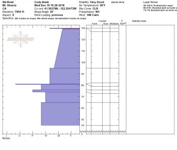
Close to 4 inches of snow fell near the Old Ski Bowl in the last 24 hours. Productive 20 mi/hr W winds blew steadily for close to 6 hours yesterday afternoon.
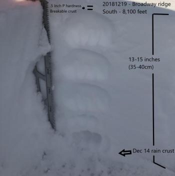
As of 2:00 p.m. yesterday, no signs of instability were observed and snowpack tests were unreactive. Whiteout conditions prevented any visuals of the upper mountain. A very soft slab had formed atop an impenetrable ice layer on an east facing aspect of lower Sun Bowl. This in itself presented no notable concern, though a denser wind slab on top of this is something to watch out for. At least 6 inches of light dry snow was available for transport on Broadway Ridge and a sustained moderate SW wind was transporting it.
Below treeline, there was 12-14 inches of low density surface snow. Warming temperatures were beginning to give it that denser heavier feel, but sliders and riders had no complaints.
Weather and Current Conditions
Weather Summary
A period of high pressure will keep things dry today and tonight. Another strong front will push through the Pacific Northwest tomorrow, the southern end of which could bring us a couple of inches of new snow above 6400 ft.
Expect strong winds above treeline today and tomorrow.
A series of warm fronts lined up over the Pacific look to keep things wet most of next week.
24 Hour Weather Station Data @ 3:00 AM
| Weather Station | Temp (°F) | Wind (mi/hr) | Snow (in) | Comments | ||||||||
|---|---|---|---|---|---|---|---|---|---|---|---|---|
| Cur | Min | Max | Avg | Avg | Max Gust | Dir | Depth | New | Water Equivalent | Settlement | ||
| Mt. Shasta City (3540 ft) | 38 | 37.5 | 43 | 40.5 | 3 | N | ||||||
| Sand Flat (6750 ft) | 30 | 29 | 33 | 31 | 34 | 2 | 0.4 | 1 | ||||
| Ski Bowl (7600 ft) | 23 | 23 | 29.5 | 26.5 | 46.9 | 3.8 | 0.81 | 1.6 | ||||
| Gray Butte (8000 ft) | 24 | 24 | 28 | 26 | 15 | 37 | W | |||||
| Castle Lake (5870 ft) | station down | |||||||||||
| Mount Eddy (6509 ft) | 24.5 | 24.5 | 34 | 30.5 | 1 | 10 | S | 30.8 | 0.6 | 0 | ||
| Ash Creek Bowl (7250 ft) | station down | |||||||||||
| Ash Creek Ridge (7895 ft) | station down |
Two Day Mountain Weather Forecast
Produced in partnership with the Medford NWS
| For 7000 ft to 9000 ft | |||
|---|---|---|---|
|
Wednesday (4 a.m. to 10 p.m.) |
Wednesday Night (10 p.m. to 4 a.m.) |
Thursday (4 a.m. to 10 p.m.) |
|
| Weather | A 20 percent chance of snow showers before 10 a.m. Mostly sunny. | Partly cloudy. Breezy and gusty. | A chance of snow before 10 a.m., then snow, possibly mixed with rain. Breezy and gusty. Chance of precipitation is 80%. |
| Temperature (°F) | 41 | 31 | 38 |
| Wind (mi/hr) | SE 5-10 | SE 10-15 | S 15-20 |
| Precipitation SWE / Snowfall (in) | / 0 | / 0 | / 1-2 |
| For 9000 ft to 11000 ft | |||
| Wednesday | Wednesday Night | Thursday | |
| Weather | A 20 percent chance of snow showers before 10 a.m. Mostly sunny. Windy and gusty. | Partly cloudy. Windy and gusty. | Snow, mainly after 4 p.m. Low wind chills. Windy and gusty. Chance of precipitation is 80%. |
| Temperature (°F) | 33 | 32 | 32 |
| Wind (mi/hr) | W 25-30 | SW 0 | SW 45-55 |
| Precipitation SWE / Snowfall (in) | / 0 | / 0 | / 1-3 |
Season Precipitation for Mount Shasta City
| Period | Measured (in) | Normal (in) | Percent of Normal (%) |
|---|---|---|---|
| From Oct 1, 2025 (the wet season) | 7.36 | 11.75 | 63 |
| Month to Date (since Jun 1, 2026) | 2.63 | 4.39 | 60 |
| Year to Date (since Jan 1, 2026) | 22.64 | 39.75 | 57 |

