

You are here
Avalanche Forecast for 2018-12-20 06:43
- EXPIRED ON December 21, 2018 @ 6:43 amPublished on December 20, 2018 @ 6:43 am
- Issued by Nick Meyers - Shasta-Trinity National Forest
Bottom Line
LOW avalanche danger will prevail for most of today for all aspects and elevations. Normal caution is advised. Expect rising avalanche danger near and above treeline later this afternoon as an approaching storm will bring strong winds and new snow to the mountains. MODERATE avalanche danger may be attained late this evening where a human triggered, wind slab avalanche could be possible.


Avalanche Problem 1: Wind Slab
-
Character ?

-
Aspect/Elevation ?
-
Likelihood ?CertainVery LikelyLikelyPossible
 Unlikely
 -
Size ?HistoricVery LargeLargeSmall

The wind slab problem remains today. Triggering a wind slab during daylight hours is unlikely, however new snow and southwesterly wind later this afternoon and tonight will contribute to fresh wind slabs, near and above treeline. Triggering a small to medium size wind slab is possible in isolated areas, steep and/or extreme terrain. Keep an eye out for dense slabs atop softer snow. Our stout rain crust could provide just the right bed surface. Signs of wind slabs are blowing snow, cornices, wind pillows, shooting cracks and/or smooth, round, hollow sounding snow.
Forecast Discussion
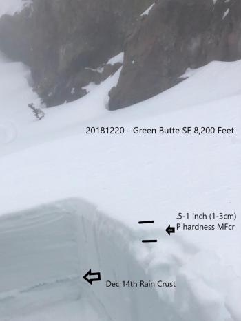
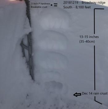
December 13/14 brought rain and misty conditions up to 8,500 - 9,000 feet in the mountains. This created a stout rain crust that dominates all aspects below said elevations. An approximate 1 foot of new snow fell on top of that. A few brief snow showers have followed along with some periods of warm temperatures and wind. This has been a perfect recipe for variable conditions. We have not seen a single avalanche during this period. Persistent avalanche problems are not a concern at this time. As new snow and wind events approach and unleash -- this is the time to be most aware of avalanche danger.
Recent Observations
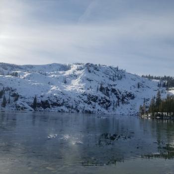
Warmer temperatures made for a tropical skiing experience as trees unloaded snow in the form of dripping water and tree bombs below treeline yesterday. Temperatures maxed out at 39 degrees F at local weather stations. A hard crust caps off 13-15 inches of softer snow, all above the December 13/14 rain crust. Dig down almost anywhere up to +/- 8,500 feet and you'll encounter this stout rain/ice layer, caused from the mournful rain and mist event this past weekend. This ice layer can essentially be dubbed "the new ground". Rollerballs/Pinwheels were observed on southerly aspects near treeline yesterday. Above treeline, winds were blowing 10-20 mi/hr out of the west/northwest and southerly slopes were observed with some wind loading. Variable crusts can be found in many areas, as well as scoured ridgelines and even some powder in more protected, low lying zones. No natural or human triggered avalanches have been observed.
Weather and Current Conditions
Weather Summary
Expect increasing cloud cover and strong pre-frontal winds to move through the region today. Tonight, we should experience a short lived, albiet heavy spurt of precipitation over the mountains. Upwards of .5 inches of precipitable water is expected, mostly between the late afternoon and evening hours. Snow levels are forecast today at 6,200 feet, but temperatures should cool off and bring snow levels down a bit tonight to 5,200 feet. You can surely count on the winds...near and above treeline, hurricane force winds are expected through the evening hours, to the tune of 50+ mi/hr in exposed areas and on the upper mountain. We will get a break in the action tomorrow. The next front moves in Saturday. This system will be more westerly, bringing an approximate 1 inch of water and slightly lower snow levels.
24 Hour Weather Station Data @ 5:00 AM
| Weather Station | Temp (°F) | Wind (mi/hr) | Snow (in) | Comments | ||||||||
|---|---|---|---|---|---|---|---|---|---|---|---|---|
| Cur | Min | Max | Avg | Avg | Max Gust | Dir | Depth | New | Water Equivalent | Settlement | ||
| Mt. Shasta City (3540 ft) | 42 | 31 | 50 | 38.5 | 1 | N | ||||||
| Sand Flat (6750 ft) | 30 | 29 | 33 | 31 | 34 | 0 | 0 | 1 | ||||
| Ski Bowl (7600 ft) | 35 | 22 | 39 | 34 | 46 | 0 | 0 | 2 | ||||
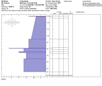
| Gray Butte (8000 ft) | 34.5 | 22 | 39 | 33.5 | 13 | 31 | NW | |||||
| Castle Lake (5870 ft) | station down | |||||||||||
| Mount Eddy (6509 ft) | 34.5 | 24.5 | 39.5 | 35 | 2 | 9 | S | 31.6 | 0 | 0 | ||
| Ash Creek Bowl (7250 ft) | station down | |||||||||||
| Ash Creek Ridge (7895 ft) | station down |
Two Day Mountain Weather Forecast
Produced in partnership with the Medford NWS
| For 7000 ft to 9000 ft | |||
|---|---|---|---|
|
Thursday (4 a.m. to 10 p.m.) |
Thursday Night (10 p.m. to 4 a.m.) |
Friday (4 a.m. to 10 p.m.) |
|
| Weather | Windy, mostly cloudy with a 40% chance of rain and snow this afternoon, after 4pm. | Snow showers likely in the evening. Snow level lowering to 5,200 feet. | Partly cloudy, lingering snow showers in the morning. |
| Temperature (°F) | 37 | 24 | 31 |
| Wind (mi/hr) | S 15-20 | SW 10-15 | N 5 |
| Precipitation SWE / Snowfall (in) | / 1-2 | / 3-6 | / 0 - .5 |
| For 9000 ft to 11000 ft | |||
| Thursday | Thursday Night | Friday | |
| Weather | Snow late this afternoon, mainly after 4pm. Snow could be heavy at times. Windy. | Snow, heavy at times, windy. | A slight chance of snow showers in the early morning, then partly cloudy. Windy. |
| Temperature (°F) | 31 | 15 | 19 |
| Wind (mi/hr) | SW 50-55 | SW 2-3 | W 15-20 |
| Precipitation SWE / Snowfall (in) | / 2-3 | / 4-7 | / 0 - .5 |
Season Precipitation for Mount Shasta City
| Period | Measured (in) | Normal (in) | Percent of Normal (%) |
|---|---|---|---|
| From Oct 1, 2025 (the wet season) | 7.36 | 12.04 | 61 |
| Month to Date (since Jun 1, 2026) | 2.63 | 4.68 | 56 |
| Year to Date (since Jan 1, 2026) | 22.64 | 40.04 | 57 |

