

You are here
Avalanche Forecast for 2019-01-17 06:30
- EXPIRED ON January 18, 2019 @ 6:30 amPublished on January 17, 2019 @ 6:30 am
- Issued by Aaron Beverly - Mount Shasta Avalanche Center
Bottom Line
Wind slabs exist and will continue to grow today as moderate to strong winds blow new snow onto the lee sides of ridges. Storm slabs are a secondary concern. Both were easy to trigger yesterday. Two feet of snow fell in the last 24 hours. Over another foot could fall today adding more weight to an unstable snowpack. Give it some time to adjust. Natural and human-triggered avalanches are likely.


Avalanche Problem 1: Wind Slab
-
Character ?

-
Aspect/Elevation ?
-
Likelihood ?CertainVery LikelyLikelyPossible
 Unlikely
 -
Size ?HistoricVery LargeLargeSmall

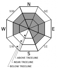
Stay off of wind loaded slopes near and above treeline. Wind slabs will be easy to trigger. Winds will continue to load northerly and easterly aspects today. They could be several feet thick. Classic start zones in Sun Bowl, Powder Bowl, and on Casaval Ridge are best avoided. Steer well clear of runout zones.
Look for convex pillows of wind-drifted snow on the lee side of ridges and other terrain features. Wind slabs may have a chalky look and feel. Shooting cracks and breaking blocks of snow are signs of instability and should alert you to the presence nearby wind slabs.
Avalanche Problem 2: Storm Slab
-
Character ?

-
Aspect/Elevation ?
-
Likelihood ?CertainVery LikelyLikelyPossible
Unlikely
-
Size ?HistoricVery LargeLargeSmall
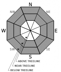
The warming storm yesterday created enough cohesion in the new snow to create storm slabs. They were easy to trigger on unsupported slopes nearing 40 degrees. Although storms slabs are short lived, continue to be wary of these today. Blocking in the top layers of snow indicates the presence of this problem. Storm slabs are typically encountered below and near treeline where the snowpack is protected from the wind.
Forecast Discussion
Avalanche danger remains elevated. New snow today will add more weight to a snowpack that is already adjusting to the 24 inches received in the last 24 hours. Give it some time. Don't ignore the obvious signs of avalanche danger. They were all seen yesterday:
- Recent avalanche activity. *
- Cracking, blocking or whumphing of the snow pack. *
- Significant snowfall in 24 hours. **
- Strong winds. **
- Temperature rise. *
* - This has happened
** - This has happened and will happen
Solid trip planning, group management and safe travel decisions are imperative today. Keep away from runout zones and all avalanche terrain.
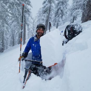
Recent Observations
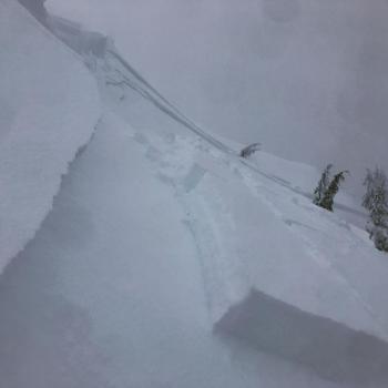
To use a non-technical term, yesterday's conditions felt avalanchey. Snow below and near treeline wanted to move and indeed did on steep slopes. Propagating wind slabs were easy to trigger in small wind loaded areas. Storm slabs released within new snow on small unsupported slopes. Column and shovel tilt tests further supported the presence of a storm slab problem. Shooting cracks and blocking were prevalent everywhere.
By mid-afternoon, new snow below treeline had become wet and heavy as temperatures spiked briefly.
In the last 24 hours, the Old Ski Bowl weather station recorded 24 inches of new snow. Near treeline, light to moderate winds blew mostly from the south.
Weather and Current Conditions
Weather Summary
A potent north moving low pressure system will continue to drive moisture into the area today, though after 10 a.m., the current storm will begin tapering off. Snow levels will stay near 4,000 feet until tomorrow afternoon when a warm front moves through causing levels to bounce to nearly 8000 feet and looks to finish off our new snow with rain.
Today strong winds will become more westerly and could reach gale force speeds above treeline. Tonight, winds will diminish. From 4,000 to 10,000 feet, 4 to 17 inches of new snow could fall in the next 24 hours with the most intense precipitation expected this morning.
24 Hour Weather Station Data @ 5:00 AM
| Weather Station | Temp (°F) | Wind (mi/hr) | Snow (in) | Comments | ||||||||
|---|---|---|---|---|---|---|---|---|---|---|---|---|
| Cur | Min | Max | Avg | Avg | Max Gust | Dir | Depth | New | Water Equivalent | Settlement | ||
| Mt. Shasta City (3540 ft) | 36 | 33 | 37 | 35 | 0 | N | ||||||
| Sand Flat (6750 ft) | 28 | 28 | 32 | 31 | 91 | 22 | 2 | 0 | ||||
| Ski Bowl (7600 ft) | 24 | 24 | 29 | 27 | 108.7 | 25 | 4.18 | 0 | ||||
| Gray Butte (8000 ft) | 23 | 23 | 27.5 | 26 | 16 | 43 | SSE | |||||
| Castle Lake (5870 ft) | station down | |||||||||||
| Mount Eddy (6509 ft) | 27 | 27 | 31 | 29.5 | 2 | 16 | SSW | 83 | 16 | 0 | ||
| Ash Creek Bowl (7250 ft) | station down | |||||||||||
| Ash Creek Ridge (7895 ft) | station down |
Two Day Mountain Weather Forecast
Produced in partnership with the Medford NWS
| For 7000 ft to 9000 ft | |||
|---|---|---|---|
|
Thursday (4 a.m. to 10 p.m.) |
Thursday Night (10 p.m. to 4 a.m.) |
Friday (4 a.m. to 10 p.m.) |
|
| Weather | Snow showers. The snow could be heavy at times. Blustery. Chance of precipitation is 100%. | Snow showers, mainly before 4 a.m, then snow likely. Chance of precipitation is 80%. | Snow before 4 p.m., then rain and snow likely. Blustery. Chance of precipitation is 90%. |
| Temperature (°F) | 31 | 25 | 33 |
| Wind (mi/hr) | South 15-20 | Southwest 10-15 | South 10-15 |
| Precipitation SWE / Snowfall (in) | / 3-7 | / 1-3 | / 1-4 |
| For 9000 ft to 11000 ft | |||
| Thursday | Thursday Night | Friday | |
| Weather | Snow showers. The snow could be heavy at times. Very windy. Sub-zero wind chills. Chance of precipitation is 100%. | Snow showers, mainly before 4 a.m., then snow likely. Very windy. Chance of precipitation is 80%. | Snow. Very windy. Low wind chills. Chance of precipitation is 90%. |
| Temperature (°F) | 17 | 13 | 31 |
| Wind (mi/hr) | Southwest 40-50 | West 9-13 | Southwest 35-45 |
| Precipitation SWE / Snowfall (in) | / 9-13 | / 1-4 | / 1-4 |
Season Precipitation for Mount Shasta City
| Period | Measured (in) | Normal (in) | Percent of Normal (%) |
|---|---|---|---|
| From Oct 1, 2025 (the wet season) | 13.93 | 19.04 | 73 |
| Month to Date (since Jun 1, 2026) | 5.52 | 3.83 | 144 |
| Year to Date (since Jan 1, 2026) | 5.52 | 3.83 | 144 |

