

You are here
Avalanche Forecast for 2019-01-19 06:21
- EXPIRED ON January 20, 2019 @ 6:21 amPublished on January 19, 2019 @ 6:21 am
- Issued by Nick Meyers - Shasta-Trinity National Forest
Bottom Line
CONSIDERABLE avalanche danger exists near and above treeline due to wind slab and cornice avalanche problems. Additional weight of rain on snow and/or heavy, wet snow may further destabilize slopes. Large, destructive avalanches remain possible today. Uncertainty exists with a storm slab avalanche problem. Carry rescue gear, know how to use it, ski and ride one at a time in avalanche terrain, don't regroup in run out zones.


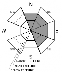
Avalanche Problem 1: Wind Slab
-
Character ?

-
Aspect/Elevation ?
-
Likelihood ?CertainVery LikelyLikelyPossible
 Unlikely
 -
Size ?HistoricVery LargeLargeSmall

Wind speeds have been ideal for wind loading. Wind slabs exist in near and above treeline terrain, along with fragile cornices. Hazard remains today on slopes below or adjacent to cornice features or wind pillows. Be conservative around these areas.
Wind has blown moderately out of the northwest to southeast over the past 3 days. Southwesterlies will be felt today in exposed terrain and further wind loading will occur. Potentially large and destructive avalanches are possible.
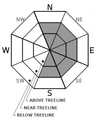
Avalanche Problem 2: Cornice
-
Character ?

-
Aspect/Elevation ?
-
Likelihood ?CertainVery LikelyLikelyPossible
Unlikely
-
Size ?HistoricVery LargeLargeSmall
Cornices exist along ridgelines and can be human triggered. Identify terra firm by looking for trees, rock(s) or other features that signify stable ground. Large cornices can sometime break back much further than expected. Give them a wide berth.
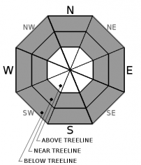
Avalanche Problem 3: Storm Slab
-
Character ?

-
Aspect/Elevation ?
-
Likelihood ?CertainVery LikelyLikelyPossible
Unlikely
-
Size ?HistoricVery LargeLargeSmall
Uncertainty exists with this avalanche problem and the initial affects of rain on snow. One to two foot thick storm slabs sitting on a weak layer of graupel and lower density snow exists below and near treeline. Observations have been limited due to access difficulties yesterday. Wet, heavy snow and rain on snow expected over the next 24 hours may wake up weaknesses within recent storm snow layers, creating an upside-down snowpack. Continue to be mindful of storm slab avalanches below and near treeline on slopes steeper than 35 degrees. If any signs of ongoing instability are encountered including recent avalanche activity, cracking, collapse, whumpfing sounds, or unstable snowpit test results, avoid exposure to avalanche terrain including low angle slopes connected to steeper terrain above.
Forecast Discussion
Upwards of 3 feet of storm snow continues to settle. Additional weight of rain on snow and heavy, wet snow on top of low density snow may destabilize slopes (upside down snowpack). Several red flags of avalanche danger are present today including wind, warming and periods of heavy (and wet) new snow. Above treeline observations and data are lacking due to very poor visibility.
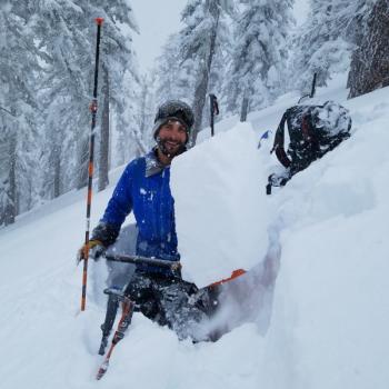
Recent Observations
- An average of 3 feet of new, unconsolidated snow has been observed above 7,000 feet. Drifts up to 60 inches + have been measured. This new snow is for the storm period of January 15th through January 17th. An additional several inches has been recorded in the last 24 hours.
- Winds have been light to moderate, averaging 10 mph with average gusts near 25 mph, primarily blowing out of the west.
- Cornices have formed on leeward NE-E-SE ridgelines.
- Treeline: Ski penetration: 4-6 inches / Boot penetration: 2-3 feet
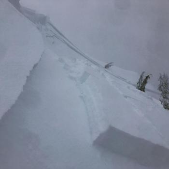
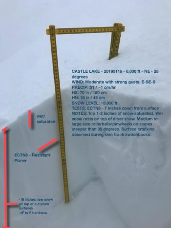
- Snowpit tests show moderate force required to activate a near treeline weak layer approximatley 12 inches deep within the snowpack, just below a prominent 1F, cohesive layer that is about 4 inches thick. This is the same layer that the Gray Butte avalanche failed on 2 days ago. (ECTN12@12"-rp, southeast facing, 30 degrees, 8,100 feet)
Weather and Current Conditions
Weather Summary
Rain is showing across most of southern Oregon and northern California this morning. Snow levels have climbed to around 7,000 feet. This frontal boundary has stalled over our area, as anticipated. Models indicate this front will wobble a bit, both north and south, bringing heavy bands of precipitation with it. Coastal areas and western Siskiyou County will receive the highest water amounts. If the cold front wobbles far enough south, snow levels could crash to near 4,000 feet. Otherwise, warm, tropical moisture associated with this system will allow for another round of precipitation today. An additional 1.71 inches of water is forecasted through Sunday evening. Tomorrow, precipitation will fade and snow levels will drop to near 5,800 feet. Winds will continue out of the south/southwest, moderate to strong, near and above treeline and alpine terrain.
24 Hour Weather Station Data @ 3:00 AM
| Weather Station | Temp (°F) | Wind (mi/hr) | Snow (in) | Comments | ||||||||
|---|---|---|---|---|---|---|---|---|---|---|---|---|
| Cur | Min | Max | Avg | Avg | Max Gust | Dir | Depth | New | Water Equivalent | Settlement | ||
| Mt. Shasta City (3540 ft) | 35.5 | 35.5 | 35.5 | 35.5 | 4 | ESE | ||||||
| Sand Flat (6750 ft) | 32 | 25 | 32 | 29 | 93 | 3 | 1 | 4 | ||||
| Ski Bowl (7600 ft) | 27 | 21.5 | 28 | 25.5 | 113.1 | 4 | 0.92 | 1.3 | ||||
| Gray Butte (8000 ft) | 25.5 | 20.5 | 26.5 | 23.5 | 10 | 25 | W | |||||
| Castle Lake (5870 ft) | station down | |||||||||||
| Mount Eddy (6509 ft) | 30.5 | 25 | 30.5 | 27.5 | 1 | 7 | S | 84 | 4 | 3 | ||
| Ash Creek Bowl (7250 ft) | station down | |||||||||||
| Ash Creek Ridge (7895 ft) | station down |
Two Day Mountain Weather Forecast
Produced in partnership with the Medford NWS
| For 7000 ft to 9000 ft | |||
|---|---|---|---|
|
Saturday (4 a.m. to 10 p.m.) |
Saturday Night (10 p.m. to 4 a.m.) |
Sunday (4 a.m. to 10 p.m.) |
|
| Weather | Rain and snow. Snow level near 6,500 feet. Chance of rain 100% | Windy, rain. Snow level near 7,400 feet. Chance of rain near 100% | Breezy, rain and snow. Snow level lowering to 5,800 feet. |
| Temperature (°F) | 38 | 32 | 35 |
| Wind (mi/hr) | South 10-15 | South 15-20 | Southwest 15-20 |
| Precipitation SWE / Snowfall (in) | / Little to no snow accumulation | / 1-3 | / 5-9 |
| For 9000 ft to 11000 ft | |||
| Saturday | Saturday Night | Sunday | |
| Weather | Snow, windy. Chance of precipitation 100% | Snow,, heavy at times, windy. Chance of precipitation 100% | Snow,, heavy at times, windy. Chance of precipitation 100% |
| Temperature (°F) | 27 and falling | 17 | 17 |
| Wind (mi/hr) | Southwest 20-30 | Southwest 8-12 | Southwest 40-50 |
| Precipitation SWE / Snowfall (in) | / 8-12 | / 12-18 | / 10-14 |
Season Precipitation for Mount Shasta City
| Period | Measured (in) | Normal (in) | Percent of Normal (%) |
|---|---|---|---|
| From Oct 1, 2025 (the wet season) | 13.93 | 19.48 | 72 |
| Month to Date (since Jun 1, 2026) | 5.52 | 4.27 | 129 |
| Year to Date (since Jan 1, 2026) | 5.52 | 4.27 | 129 |

