

You are here
Avalanche Forecast for 2019-01-22 06:00
- EXPIRED ON January 23, 2019 @ 6:00 amPublished on January 22, 2019 @ 6:00 am
- Issued by Ryan Sorenson - Mount Shasta Avalanche Center
Bottom Line
The avalanche danger is LOW for all elevations and aspects. Use normal caution. Continue to watch for isolated wind slabs. Pay attention to locally gusty winds along ridgelines of higher terrain. Use caution if climbing into the alpine today. Scoured, icy slopes present slide for life conditions.


Avalanche Problem 1: Normal Caution
-
Character ?

-
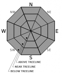
Aspect/Elevation ?
-
Likelihood ?CertainVery LikelyLikelyPossible
 Unlikely
 -
Size ?HistoricVery LargeLargeSmall

Small, isolated wind slab avalanches are possible in leeward terrain. Moderate to strong wind was felt yesterday. Locally gusty winds will continue today out of the north/northwest. Cornices exist along ridgelines and could be human triggered. Identify terra firm by looking for trees, rock(s) or other features that signify stable ground. Give them a wide berth. Scoured icy slopes present slide for life conditions. An ice axe, crampons, and helmet are mandatory if climbing into the upper regions of the mountain, but realize that self-arrest will be difficult.
Remember, low danger does not mean no danger. Use the ethos of normal caution to minimize consequences of the isolated avalanche event. Carry a beacon, shovel, and probe and know how to use them. Create a travel plan, stick to your travel plan, carry companion rescue gear, actively look for evidence of instability while on the snow, communicate well within your group, and expose only one person at a time to avalanche terrain.
Recent Observations
Windy and cold conditions were felt on the mountain yesterday. Most of the available snow has been hard packed or blown from the upper elevations.
Current snow conditions include:
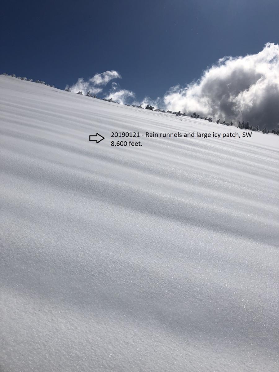
- Evidence of rain on snow and deep rain runnels.
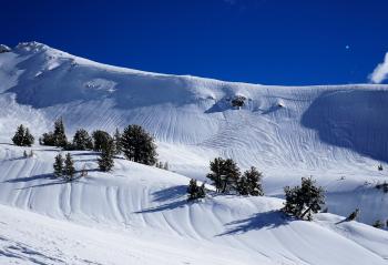
- Many cornice failures have occurred on ridgelines.
- Supportable crust near and above treeline with pockets of smooth, dry powder.
- Wind affected snow near and above treeline from steady wind and strong gusts over the past 24 hours.
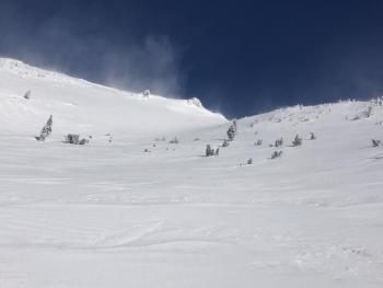
- Blowing snow visible on ridges, locally gusty conditions.
- Dry, chalky, hard wind textured snow above 8,000 feet.
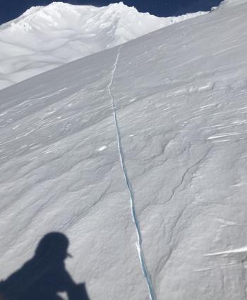
- Ridgelines scoured with heavy rime and ice plastered to exposed areas. (see picture below)

Weather and Current Conditions
Weather Summary
A high pressure ridge has moved into the area from the west. Mostly sunny conditions will prevail for the foreseeable future. A warm frontal system will miss the forecast area to our north, bringing scattered high level clouds and warming temperatures today. The northerly wind will continue to be moderate with strong gusts, announcing this change in weather pattern. Temperatures will continue to rise throughout the week.
24 Hour Weather Station Data @ 5:00 AM
| Weather Station | Temp (°F) | Wind (mi/hr) | Snow (in) | Comments | ||||||||
|---|---|---|---|---|---|---|---|---|---|---|---|---|
| Cur | Min | Max | Avg | Avg | Max Gust | Dir | Depth | New | Water Equivalent | Settlement | ||
| Mt. Shasta City (3540 ft) | 31 | 31 | 48 | 39.5 | 1 | N | ||||||
| Sand Flat (6750 ft) | 14 | 13 | 27 | 20 | 88 | 1 | 0 | 3 | ||||
| Ski Bowl (7600 ft) | 17.5 | 13.5 | 24 | 18 | 106 | 1 | 0 | 3 | ||||
| Gray Butte (8000 ft) | 14 | 13 | 28.5 | 19 | 4 | 18 | SE | |||||
| Castle Lake (5870 ft) | ||||||||||||
| Mount Eddy (6509 ft) | 22 | 19 | 24.5 | 21.5 | 0 | 7 | 78 | 0 | 0 | |||
| Ash Creek Bowl (7250 ft) | ||||||||||||
| Ash Creek Ridge (7895 ft) |
Two Day Mountain Weather Forecast
Produced in partnership with the Medford NWS
| For 7000 ft to 9000 ft | |||
|---|---|---|---|
|
Tuesday (4 a.m. to 10 p.m.) |
Tuesday Night (10 p.m. to 4 a.m.) |
Wednesday (4 a.m. to 10 p.m.) |
|
| Weather | Mostly sunny, moderate wind with strong gusts | Mostly cloudy in the evening then clearing | Partly cloudy. Highs in the lower to mid 40s |
| Temperature (°F) | 38 | 32 | 41 |
| Wind (mi/hr) | North 10-15 | Northwest 10-15 | Northwest 10-15 |
| Precipitation SWE / Snowfall (in) | / 0 | / 0 | / 0 |
| For 9000 ft to 11000 ft | |||
| Tuesday | Tuesday Night | Wednesday | |
| Weather | Mostly sunny, windy with strong gusts | Mostly clear, windy with strong gusts | Partly cloudy and windy |
| Temperature (°F) | 30 | 25 | 30 |
| Wind (mi/hr) | Northwest 15-25 | Northwest 0 | Northwest 15-20 |
| Precipitation SWE / Snowfall (in) | / 0 | / 0 | / 0 |
Season Precipitation for Mount Shasta City
| Period | Measured (in) | Normal (in) | Percent of Normal (%) |
|---|---|---|---|
| From Oct 1, 2025 (the wet season) | 13.93 | 20.13 | 69 |
| Month to Date (since Jun 1, 2026) | 5.52 | 4.92 | 112 |
| Year to Date (since Jan 1, 2026) | 5.52 | 4.92 | 112 |

