

You are here
Avalanche Forecast for 2019-02-01 05:22
- EXPIRED ON February 2, 2019 @ 5:22 amPublished on February 1, 2019 @ 5:22 am
- Issued by Nick Meyers - Shasta-Trinity National Forest
Bottom Line
Winter weather will bring heavy snow to the area over the next 24 hours. Southerly flow will host strong winds. Avalanche problems will include fresh wind slabs, cornices and potentially storm slabs. Heightened awareness will be necessary today on specific terrain features. LOW danger this morning will increase to MODERATE danger for most areas this afternoon as new snow accumulates. Near and above treeline, CONSIDERABLE danger is possible late today and into the night.


Avalanche Problem 1: Wind Slab
-
Character ?

-
Aspect/Elevation ?
-
Likelihood ?CertainVery LikelyLikelyPossible
 Unlikely
 -
Size ?HistoricVery LargeLargeSmall

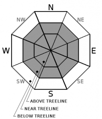
Fresh wind slabs will form near and above treeline today. Southerly wind will blow 40+ mi/hr over exposed terrain. Existing snow surfaces are firm and smooth where new wind slabs will form. Wind slabs look smooth and rounded, lens or pillow shaped, and chalky-white color. They can feel “slabby” (i.e. harder snow on top of softer snow) and often sound hollow like a drum. You may notice cracks shooting away from you–the longer the crack, the more dangerous. They can be very soft to so hard that you can hardly kick a boot into it. If you find any of these clues and are on a steep slope without anchors, then it almost always means danger.
What you should do:
• Stop immediately! Don’t go any farther!
• Back off if you’re on a big slope and dig down to investigate how well the slab is bonded to the underlying snow
• Jump on a few safe, test slopes to see how the snow responds.
• If the slab breaks away easily on your tests, don’t cross larger slopes. Go back the way you came or find another route that avoids wind slabs.
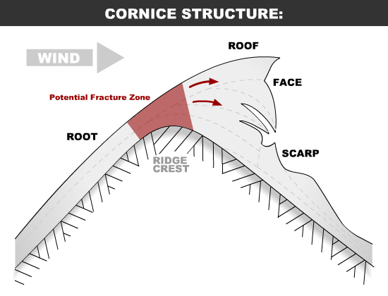
Avalanche Problem 2: Cornice
-
Character ?

-
Aspect/Elevation ?
-
Likelihood ?CertainVery LikelyLikelyPossible
Unlikely
-
Size ?HistoricVery LargeLargeSmall
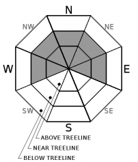
New cornice features may begin to form onto existing, corniced ridgelines. Southerly wind will cause cornices to form on northerly facing aspects. Places like Middle Peak of the Castle Lake area are a perfect example of terrain to be cautious of.
Avalanche Problem 3: Storm Slab
-
Character ?

-
Aspect/Elevation ?
-
Likelihood ?CertainVery LikelyLikelyPossible
Unlikely
-
Size ?HistoricVery LargeLargeSmall
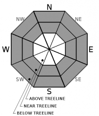
Storm Slab avalanches are the release of a cohesive layer (a slab) of new snow that breaks within new snow or on the old snow surface. Storm-slabs typically last between a few hours and few days (following snowfall). Storm slabs will be unlikely today, but possible tonight. Below and near treeline, protected areas where more than 8 inches of snow has fallen, storm slabs will be possible.
Forecast Discussion
A WINTER STORM WARNING is in effect from 1pm this afternoon to 4pm PST Saturday above 5,000 feet. Strong southerly winds will impact much of the mountains today. Evaluate snow and terrain carefully. Cautious route-finding and conservative decision making will be essential as the storm develops over the next 24 hours, and further into the weekend.
Recent Observations
Temperatures have ranged from 31 to 46 degrees F in the last 24 hours near 7,600 feet on Mount Shasta. Winds have picked up this morning, averaging 11 mi/hr, gusting up to 25 mi/hr at 8,000 feet. The height of snow (HS) at 7,600 feet is 92 inches.
Temperatures at Castle Lake ranged from 35 to 52 degrees F in the last 24 hours near 5,800 feet. The temperature on Mount Eddy ranged from 32 to 45 degrees F near 6,500 feet. The wind has increased this morning out of the southwest in the Eddies. The height of snow is 55 inches at 5,800 feet and 68 inches at 6,500 feet.
Current snow conditions are variable leading up to this weekends storm. A myriad of snow surface descriptions can be used: rain runnels, breakable crust, melt freeze corn, sastrugi features, packed powder, firm and icy.
No avalanches or signs of instability have been observed since last weekend.
Weather and Current Conditions
Weather Summary
Our period of quiet and stagnant weather is coming to an end. A Winter Weather Advisory has been issued from late this afternoon into Saturday morning and active weather is going to be the new normal for at least the weekend. Three distinct periods of precipitation will occur as moderate to strong southerly flow will pump moisture over Northern California. Siskiyou County will received the most impact with moderate snow amounts between 4,000 and 5,000 feet and heavy snow above 5,000 feet. Snow levels should linger around Snowmans Summit elevation. The second regime of active weather will begin Saturday night and into Sunday morning. Mountain show showers and valley rain can be expected. Snow levels will linger near 5,000 feet. The third and most impactful systems will approach Sunday. Timing and tracking for this system is getting dialed in. The jist...expect more heavy snow for Northern California Sunday night into Monday morning.
24 Hour Weather Station Data @ 5:00 AM
| Weather Station | Temp (°F) | Wind (mi/hr) | Snow (in) | Comments | ||||||||
|---|---|---|---|---|---|---|---|---|---|---|---|---|
| Cur | Min | Max | Avg | Avg | Max Gust | Dir | Depth | New | Water Equivalent | Settlement | ||
| Mt. Shasta City (3540 ft) | 29 | 29 | 57 | 40 | 0 | N | ||||||
| Sand Flat (6750 ft) | 33 | 29 | 46 | 36 | 75 | 0 | .15 | 0 | ||||
| Ski Bowl (7600 ft) | 31.5 | 31 | 46 | 36.5 | 92 | 0 | 0.19 | 0 | ||||
| Gray Butte (8000 ft) | 30.5 | 30 | 45.5 | 35.5 | 6 | 25 | S | |||||
| Castle Lake (5870 ft) | 35.5 | 35 | 52.5 | 41 | 52 | 0 | 0 | |||||
| Mount Eddy (6509 ft) | 33.5 | 32 | 45.5 | 38 | 2 | 19 | SSW | 66 | 0 | 0 | ||
| Ash Creek Bowl (7250 ft) | ||||||||||||
| Ash Creek Ridge (7895 ft) |
Two Day Mountain Weather Forecast
Produced in partnership with the Medford NWS
| For 7000 ft to 9000 ft | |||
|---|---|---|---|
|
Friday (4 a.m. to 10 p.m.) |
Friday Night (10 p.m. to 4 a.m.) |
Saturday (4 a.m. to 10 p.m.) |
|
| Weather | Snow, breezy. Snow level near 5,700 feet | Snow. The snow could be heavy at times. Windy. Snow level near 4,600 feet | Snow. The snow could be heavy at times. Breezy. Snow level near 4,800 feet |
| Temperature (°F) | 36 | 30 | 34 |
| Wind (mi/hr) | South 20-25 | South 20-25 | South 15-20 |
| Precipitation SWE / Snowfall (in) | / 5-9 | / 6-12 | / 4-10 |
| For 9000 ft to 11000 ft | |||
| Friday | Friday Night | Saturday | |
| Weather | Snow. The snow could be heavy at times. Windy. | Snow. The snow could be heavy at times. Windy. | Snow before 10am, then snow showers after. The snow could be heavy at times. Windy. |
| Temperature (°F) | 22 | 21 | 22 |
| Wind (mi/hr) | South 40-50 | South 9-13 | South 30-40 |
| Precipitation SWE / Snowfall (in) | / 9-13 | / 13-19 | / 10-16 |
Season Precipitation for Mount Shasta City
| Period | Measured (in) | Normal (in) | Percent of Normal (%) |
|---|---|---|---|
| From Oct 1, 2025 (the wet season) | 13.93 | 22.27 | 63 |
| Month to Date (since Jun 1, 2026) | 5.52 | 7.06 | 78 |
| Year to Date (since Jan 1, 2026) | 5.52 | 7.06 | 78 |

