

You are here
Avalanche Forecast for 2019-02-02 06:04
- EXPIRED ON February 3, 2019 @ 6:04 amPublished on February 2, 2019 @ 6:04 am
- Issued by Nick Meyers - Shasta-Trinity National Forest
Bottom Line
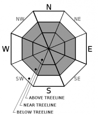
A warm to cold progression of winter storms is in progress. Periods of heavy snow and strong southerly wind will continue to ripen avalanche conditions. Wind slabs, storm slabs and cornice avalanche problems will wax and wane throughout the storm series. The avalanche danger will linger at MODERATE today below treeline and CONSIDERABLE near and above treeline. Ski and ride one at a time in avalanche terrain. Communicate with your group. Have a rescue plan in place.


Avalanche Problem 1: Wind Slab
-
Character ?

-
Aspect/Elevation ?
-
Likelihood ?CertainVery LikelyLikelyPossible
 Unlikely
 -
Size ?HistoricVery LargeLargeSmall

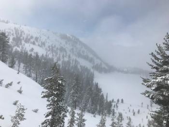
Near and above treeline, a wind slab problem has begun. Ten inches of new snow over the past 24 hours and moderate, southerly winds have made for near perfect wind loading conditions. Direct wind loading of northerly slopes is most likely, however cross-loading of some westerly and easterly aspects is possible. Slopes below or adjacent to cornice features will be most suspect.
What you should do:
• Stop immediately! Don’t go any further!
• Back off if you’re on a big slope and dig down to investigate how well the slab is bonded to the underlying snow
• Jump on a few safe, test slopes to see how the snow responds.
• If the slab breaks away easily on your tests, don’t cross larger slopes. Go back the way you came or find another route that avoids wind slabs.
Avalanche Problem 2: Cornice
-
Character ?

-
Aspect/Elevation ?
-
Likelihood ?CertainVery LikelyLikelyPossible
Unlikely
-
Size ?HistoricVery LargeLargeSmall
Watch for fresh cornices along ridgelines today, and as the storm progresses. In general, average wind speeds in the teens are perfect for cornice formation. Use a small wind lip as a test slope. If you are able to trigger small cornices, know that larger ones could be possible. Places like Middle Peak at Castle Lake, Green Butte and Casaval ridgelines, the top of Sun Bowl and Powder Bowl and the north ridge of Gray Butte are all perfect places where unstable cornices might exist. Wind will blow from southerly directions all weekend.
Avalanche Problem 3: Storm Slab
-
Character ?

-
Aspect/Elevation ?
-
Likelihood ?CertainVery LikelyLikelyPossible
Unlikely
-
Size ?HistoricVery LargeLargeSmall
Storm slabs are most common below and near treeline during periods of light or no wind, and/or protected areas. They are the most sensitive during periods of heavy, rapid snow accumulation. Storm Slab avalanches are the release of a cohesive layer (a slab) of new snow that breaks within new snow, or on the old snow surface. The weak point can be snow that fell early in the storm or just a poor bond with the old snow surface. Like a chain, it can just be the weakest part of a snow layer that formed in a single storm or prolonged snowy period. Storm-slabs typically last between a few hours and few days (following snowfall). Any aspect below and near treeline, storm slabs are possible and could be big enough to bury a person and/or sweep one off their feet and into trees, rocks, cliff, etc.
Forecast Discussion
You don't have to be a snow nerd to stay out of trouble this weekend. Pay attention to even the most simple observations like rapid accumulation of new snow, cracking or collapsing of the snowpack, wind blowing snow, and/or recent avalanches. When the snowpack is in question, terrain is the answer! We can all still have fun on slopes less than 30 degrees. Keep it tight out there folks!
A winter storm warning is still in effect until 4pm PST this afternoon above 5,000 feet. A winter storm watch has been issued from Sunday afternoon through Monday evening above 2,500 feet. Strong south winds above 10,000 feet are expected this morning.
For the most detailed weather information, you can visit our nearest NWS office here.
Recent Observations
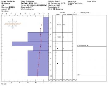
- Below snow surfaces, the existing snowpack is well bonded on all aspects and is in good shape to handle new snow loading. Any avalanche activity during the in progress storm will occur either at the old/new snow interface or within the storm snow.
- Precipitation for the current storm series began yesterday at 4am. Nearly constant rain and snow has occurred since then.
- Snow struggled to accumulate at treeline due to warmer temperatures during the day, but started to pile up last night.
- Temps have ranged from 26 to 31 degrees F in the last 24 hours near treeline on the mountain with 10 inches of new snow.
- On the west side, the Eddies received about 8 inches of new snow, Castle Lake area about 6 inches.
- Southerly winds have been strong over exposed, alpine regions of Mount Shasta. Below and near treeline, wind speeds have been moderate. Gray Butte weather station has recorded average wind speeds of 12 mi/hr, gusting to 30.
- Avalanches and signs of instability yesterday were minimal due to rain on snow, heavy wet snow and overall low snow accumulation rates. We were not able to get any above treeline observations yesterday.
- New snow falls on a variety of generally smooth surfaces including melt-freeze corn snow, crusts, sastrugi features and firm/icy snow surfaces.
Weather and Current Conditions
Weather Summary
The games have begun here in Southern Siskiyou County as a series of storms play through the area. Deep, southerly flow will bring moderate to heavy precipitation to the area this morning with snow levels near 4,500 feet. Snow showers will taper off this evening. The second system will approach and move through the area on Sunday/Monday. Along with ample water predictions (2.38 inches of water is forecast by Tuesday morning), cold arctic air pushes southward and will bring much cooler temperatures, as well as lower snow levels. Expect things to look and feel a little more winter-like in town, come next work week. In short, continued precipitation, cooling temperatures and sustained southerly wind is the soup de jour for the foreseable future.
24 Hour Weather Station Data @ 5:00 AM
| Weather Station | Temp (°F) | Wind (mi/hr) | Snow (in) | Comments | ||||||||
|---|---|---|---|---|---|---|---|---|---|---|---|---|
| Cur | Min | Max | Avg | Avg | Max Gust | Dir | Depth | New | Water Equivalent | Settlement | ||
| Mt. Shasta City (3540 ft) | 29 | 29 | 57 | 40 | 0 | N | ||||||
| Sand Flat (6750 ft) | 32 | 30 | 34 | 32 | 81 | 6 | 1 | .5 | ||||
| Ski Bowl (7600 ft) | 28.5 | 26 | 31.5 | 28 | 102 | 10 | 2.44 | .5 | ||||
| Gray Butte (8000 ft) | 27 | 25 | 30.5 | 27 | 12 | 31 | SSE | |||||
| Castle Lake (5870 ft) | 31 | 29.5 | 35.5 | 32 | 57 | 5 | 1 | |||||
| Mount Eddy (6509 ft) | 29.5 | 28.5 | 33.5 | 30.5 | 3 | 22 | SW | 70 | 8 | .5 | ||
| Ash Creek Bowl (7250 ft) | ||||||||||||
| Ash Creek Ridge (7895 ft) |
Two Day Mountain Weather Forecast
Produced in partnership with the Medford NWS
| For 7000 ft to 9000 ft | |||
|---|---|---|---|
|
Saturday (4 a.m. to 10 p.m.) |
Saturday Night (10 p.m. to 4 a.m.) |
Sunday (4 a.m. to 10 p.m.) |
|
| Weather | Snow this morning and snow showers this afternoon, windy. Snow level near 4,500 feet. | Snow showers. Snow level near 4,000 feet. | Snow in the morning, then showers in the afternoon. Snow levels near 3,500 feet. |
| Temperature (°F) | 35 | 27 | 29 |
| Wind (mi/hr) | Southeast 10-15 | South 5-10 | South 5-10 |
| Precipitation SWE / Snowfall (in) | / 3-6 | / 2-4 | / 4-8 |
| For 9000 ft to 11000 ft | |||
| Saturday | Saturday Night | Sunday | |
| Weather | Snow, heavy at times. Windy. | Snow showers | Snow, windy. |
| Temperature (°F) | 21 and falling | 13 | 15 |
| Wind (mi/hr) | South 35-45 | Southwest 4-7 | Southwest 15-25 |
| Precipitation SWE / Snowfall (in) | / 4-7 | / 3-5 | / 5-9 |
Season Precipitation for Mount Shasta City
| Period | Measured (in) | Normal (in) | Percent of Normal (%) |
|---|---|---|---|
| From Oct 1, 2025 (the wet season) | 15.24 | 22.51 | 68 |
| Month to Date (since Jun 1, 2026) | 1.31 | 0.24 | 546 |
| Year to Date (since Jan 1, 2026) | 6.83 | 7.30 | 94 |

