

You are here
Avalanche Forecast for 2019-02-03 06:30
- EXPIRED ON February 4, 2019 @ 6:30 amPublished on February 3, 2019 @ 6:30 am
- Issued by Aaron Beverly - Mount Shasta Avalanche Center
Bottom Line
Significant snow and moderate to strong winds are expected in the next 24 hours. These are obvious signs of avalanche danger. Most precipitation will come tonight along with a 500-foot snow level. Don't let epic ski conditions lull you into complacency. Be wary of wind slabs, weak cornices, and storm slabs. Careful snowpack evaluation, cautious route-finding, and conservative decision-making will be essential.


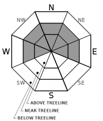
Avalanche Problem 1: Wind Slab
-
Character ?

-
Aspect/Elevation ?
-
Likelihood ?CertainVery LikelyLikelyPossible
 Unlikely
 -
Size ?HistoricVery LargeLargeSmall

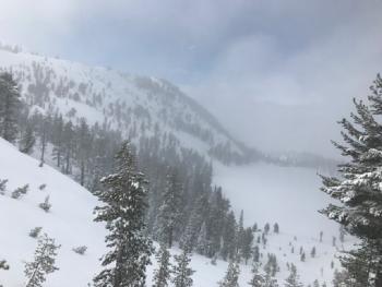
Wind slabs are forming along ridges near and above treeline. With significant snow and moderate to strong winds expected in 24 hours, expect continued growth of wind slabs. These could be several feet thick.
Direct wind loading of northerly slopes is likely. Cross loading of westerly and easterly aspects is possible. Slopes below or adjacent to cornice features will be most suspect.
If you are experience cracking, blocking, or whumphing:
- Stop immediately! Don’t go any further.
- Back off and dig down to investigate how well the slab is bonded to the underlying snow.
- Jump on a few safe, test slopes to see how the snow responds.If the slab breaks away easily on your tests, don’t cross slopes greater than 35 degrees. Go back the way you came or find another route.
Avalanche Problem 2: Cornice
-
Character ?

-
Aspect/Elevation ?

-
Likelihood ?CertainVery LikelyLikelyPossible
Unlikely
-
Size ?HistoricVery LargeLargeSmall
Beware of cornices forming atop north, east, and west facing ridges. Middle Peak above Castle Lake, Sun Bowl, Powder Bowl, Casaval Ridge, Gray Butte - these are all common collectors. You should not find yourself below these, but if above, steer clear.
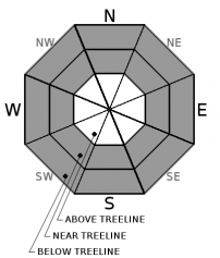
Avalanche Problem 3: Storm Slab
-
Character ?

-
Aspect/Elevation ?
-
Likelihood ?CertainVery LikelyLikelyPossible
Unlikely
-
Size ?HistoricVery LargeLargeSmall
Storm slabs are most common below and near treeline on slopes near or above 40 degrees. They are the most sensitive during periods of heavy, rapid snow accumulation. Storm slab avalanches are the release of a cohesive layer of new snow that breaks within new snow, or on the old snow surface. They are confined to wind protected areas.
Forecast Discussion
If snow amounts and temperatures verify, conditions will attract ski heroes out into the backcountry. But 24 inches of snow in 24 hours coupled with moderate to strong winds is a villain for which you better prepare. Significant snow and winds are blatant signs of avalanche danger.
All heroes have weaknesses. Today and tonight, they are leeward slopes and steep terrain.
Recent Observations
In the last 48 hours, we have received 14 inches of snow. Temperatures have ranged from 31 to 23 degrees. Near treeline, winds have been light from the west and south. Above treeline, moderate winds have been loading the lee side of ridges.
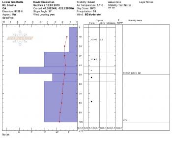
The recent storm came in warm. Snowpack is right side up with new snow bonding well with old snow. No new avalanches have been observed, though visibility has been obscured.
Northerly aspects have become wind loaded. Some minor cracking was observed. Wind drifts measured up to 30 inches. ECT test were inconclusive.
For the month of February, we are 423% of normal for precipitation!
Weather and Current Conditions
Weather Summary
Apparently we are about to be hit by two unusual fronts. A polar front today, followed tonight by an artic front. Sound cold? Snow levels will drop from 4,500 feet to 500 feet. Temperatures above treeline will be downright frigid.
Expect significant snow fall by tomorrow with the brunt of it coming tonight. We could see up to two feet of snow in the next 24 hours.
Southwest winds near and above treeline will be moderate to strong causing temperatures to chill to the bone. Don't forget to bring your puffy.
24 Hour Weather Station Data @ 6:00 AM
| Weather Station | Temp (°F) | Wind (mi/hr) | Snow (in) | Comments | ||||||||
|---|---|---|---|---|---|---|---|---|---|---|---|---|
| Cur | Min | Max | Avg | Avg | Max Gust | Dir | Depth | New | Water Equivalent | Settlement | ||
| Mt. Shasta City (3540 ft) | 37 | 37 | 43 | 39.5 | 1 | N | ||||||
| Sand Flat (6750 ft) | 26 | 26 | 33 | 31 | 85 | 2 | 0.44 | 0 | ||||
| Ski Bowl (7600 ft) | 22.5 | 22.5 | 31.5 | 26.5 | 106.1 | 4 | 0.92 | 0 | ||||
| Gray Butte (8000 ft) | 21.5 | 21.5 | 29 | 25.5 | 11 | 37 | WSW | |||||
| Castle Lake (5870 ft) | 26.5 | 26.5 | 34.5 | 30 | 68 | 8 | 0 | |||||
| Mount Eddy (6509 ft) | 25 | 24.5 | 31 | 28 | 1 | 8 | S | 78 | 2 | 0 | ||
| Ash Creek Bowl (7250 ft) | station down | |||||||||||
| Ash Creek Ridge (7895 ft) | station down |
Two Day Mountain Weather Forecast
Produced in partnership with the Medford NWS
| For 7000 ft to 9000 ft | |||
|---|---|---|---|
|
Sunday (4 a.m. to 10 p.m.) |
Sunday Night (10 p.m. to 4 a.m.) |
Monday (4 a.m. to 10 p.m.) |
|
| Weather | Snow before 10 a.m., then snow showers after 10 a.m. Chance of precipitation is 100%. | Snow showers. Chance of precipitation is 100%. | Snow showers. Chance of precipitation is 100%. |
| Temperature (°F) | 29 | 20 | 22 |
| Wind (mi/hr) | South 5-10 | South 10-15 | Southwest 10-15 |
| Precipitation SWE / Snowfall (in) | / 1-4 | / 7-11 | / 4-7 |
| For 9000 ft to 11000 ft | |||
| Sunday | Sunday Night | Monday | |
| Weather | Snow before 10 a.m., then snow showers after 10 a.m. Windy and gusty. Low wind chills. Chance of precipitation is 100%. | Snow showers. The snow could be heavy at times. Windy and gusty. Below freeing wind chils. Chance of precipitation is 100%. | Snow showers. The snow could be heavy at times. Windy and gusty. Below freezing wind chills. Chance of precipitation is 100%. |
| Temperature (°F) | 12 | 11 | 7 |
| Wind (mi/hr) | Southwest 20-25 | Southwest 7-10 | Southwest 30-35 |
| Precipitation SWE / Snowfall (in) | / 7-10 | / 14-19 | / 8-11 |
Season Precipitation for Mount Shasta City
| Period | Measured (in) | Normal (in) | Percent of Normal (%) |
|---|---|---|---|
| From Oct 1, 2025 (the wet season) | 15.96 | 22.75 | 70 |
| Month to Date (since Jun 1, 2026) | 2.03 | 0.48 | 423 |
| Year to Date (since Jan 1, 2026) | 7.55 | 7.54 | 100 |

