

You are here
Avalanche Forecast for 2019-02-04 06:00
- EXPIRED ON February 5, 2019 @ 6:00 amPublished on February 4, 2019 @ 6:00 am
- Issued by Ryan Sorenson - Mount Shasta Avalanche Center
Bottom Line
Unstable wind slabs and storm slabs near and above treeline are likely to be triggered by sliders and riders over the next 24 hours. Be wary of weak cornices and loose snow. Careful snowpack evaluation, cautious route-finding, and conservative decision-making will be essential. Carry rescue gear, know how to use it, ski and ride one at a time in avalanche terrain, don't regroup in runout zones. Travel in or below steep avalanche terrain is not recommended.


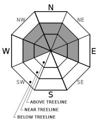
Avalanche Problem 1: Wind Slab
-
Character ?

-
Aspect/Elevation ?
-
Likelihood ?CertainVery LikelyLikelyPossible
 Unlikely
 -
Size ?HistoricVery LargeLargeSmall

Wind slabs are forming along ridges near and above treeline. With significant snow and moderate to strong winds expected in 24 hours, expect continued growth of wind slabs. These could be several feet thick.
Direct wind loading of northerly slopes is likely. Cross loading of westerly and easterly aspects is possible. Slopes below or adjacent to cornice features will be most suspect.
If you are experience cracking, blocking, or whumphing:
- Stop immediately! Don’t go any further.
- Back off and dig down to investigate how well the slab is bonded to the underlying snow.
- Jump on a few safe, test slopes to see how the snow responds.If the slab breaks away easily on your tests, don’t cross slopes greater than 35 degrees. Go back the way you came or find another route.
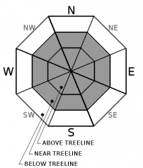
Avalanche Problem 2: Loose Dry
-
Character ?

-
Aspect/Elevation ?
-
Likelihood ?CertainVery LikelyLikelyPossible
Unlikely
-
Size ?HistoricVery LargeLargeSmall
The cold temperature today and tonight will dry out our snowpack creating conditions favourable for loose dry avalanches. Loose snow sliding down a mountainside is called a loose snow avalanche. Loose snow avalanches usually start from a point and fan outward as they descend. These seemingly harmless "sluff" avalanches can easily take the victim over cliffs, into crevasses or bury them deeply in a terrain trap such as a gully. Loose snow avalanches shouldn't be taken lightly and could even trigger deeper slabs below. Avoid steep exposed slopes and be mindful of terrain traps and gullies.
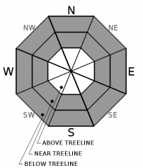
Avalanche Problem 3: Storm Slab
-
Character ?

-
Aspect/Elevation ?
-
Likelihood ?CertainVery LikelyLikelyPossible
Unlikely
-
Size ?HistoricVery LargeLargeSmall
Storm slabs are most common below and near treeline on slopes near or above 40 degrees. They are the most sensitive during periods of heavy, rapid snow accumulation. Storm slab avalanches are the release of a cohesive layer of new snow that breaks within new snow, or on the old snow surface.
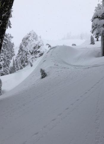
Recent storm slab instabilities have been observed on Gray Bute yesterday. Another 4-12 inches of snow will only add more weight to this unstable condition. Proper terrain navigation techniques and group management are increasingly important. Avoid steep slopes below and near treeline today.
Forecast Discussion
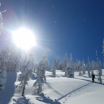
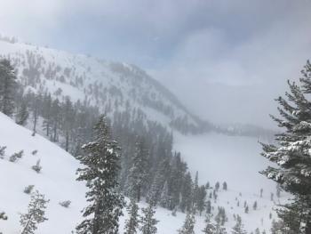
Beware of cornices forming atop north, east, and west facing ridges. Middle Peak above Castle Lake, Sun Bowl, Powder Bowl, Casaval Ridge, Gray Butte - these are all common collectors.
If you venture out, keep in mind the 5 red flags indicating avalanche danger:
Recent avalanche activity.
- Cracking, blocking or whumphing of the snow pack.
- Significant snowfall in 24 hours.
- Strong winds.
- Temperature rise.
- Solid trip planning, group management and safe travel decisions are imperative today. Keep away from runout zones and all avalanche terrain.
Solid trip planning, group management and safe travel decisions are imperative today. Keep away from runout zones and all avalanche terrain.
Recent Observations
We have received 23 inches of snow since Friday at Old Ski bowl 7,600 feet. New snow totals were 18-20 inches at the top of Gray Butte yesterday. Temperatures have ranged from 20 to 31 degrees in the last 24 hours. Near treeline, winds have been increasing from light to moderate from the west and south last night. Strong gusts up to 37 mi/hr were recorded on Gray Butte last night.
Temperatures at Castle Lake ranged from 24 to 37 degrees F in the last 24 hours near 5,800 feet. The temperature at Mount Eddy ranged from 22 to 30 degrees F near 6,500 feet. The wind has also remained light to moderate out of the south-east for the last 24 hours in the Eddies. The height of snow (HS) is 73 inches at 5,800 feet and 78 inches at 6,500 feet.
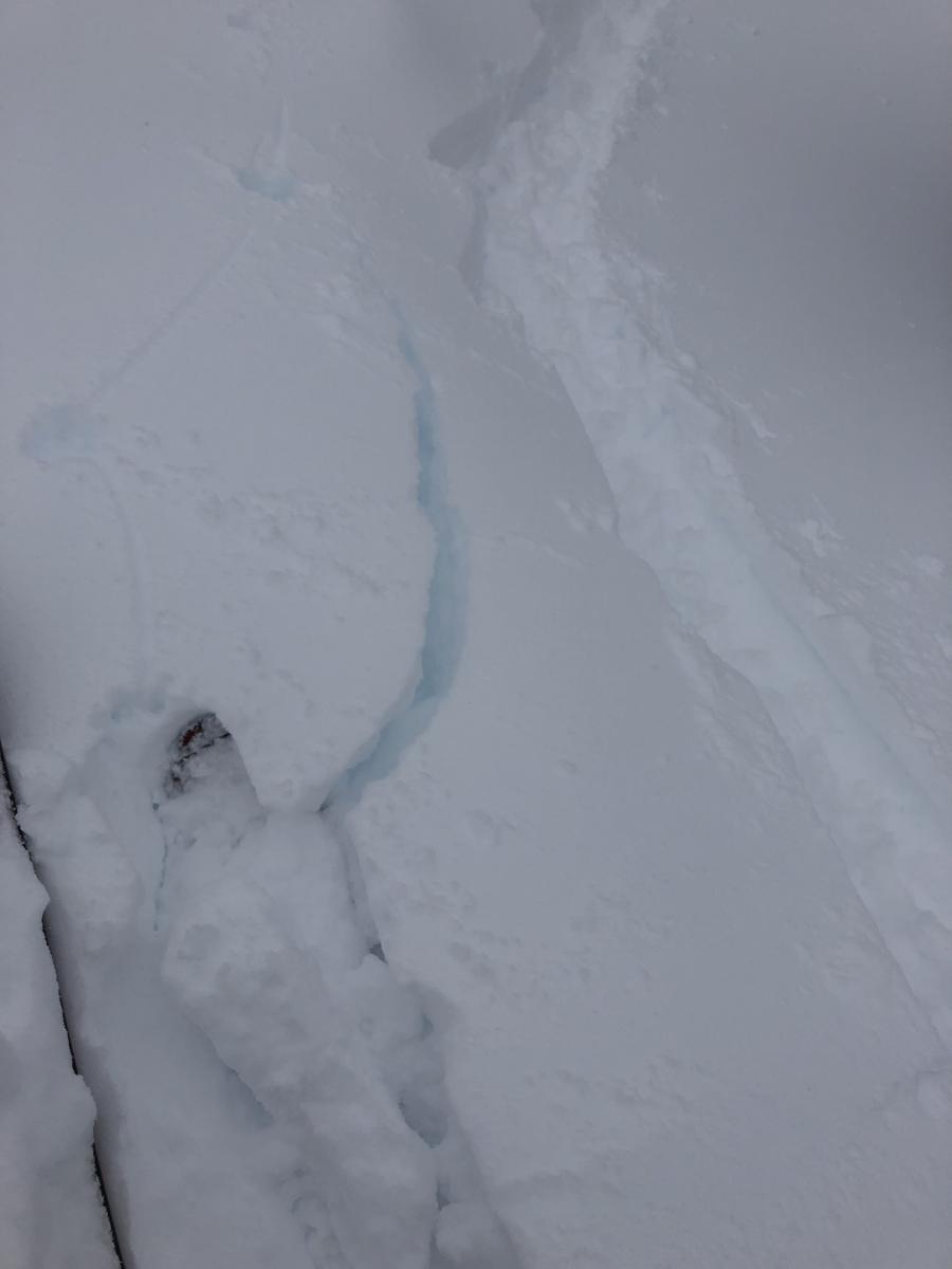
A tour up Gray Butte yesterday saw wind affected snow and small to medium drifts forming on leeward aspects. Cracking and instabilities confirm that wind slabs are forming but seem stubborn to trigger. Some results were seen on soft storm slabs on steeper terrain above 40 degrees was breaking 6-12 inches down on a density change in the new snow. Shooting cracks and small D .5 avalanches were observed on test slopes. Test pits saw Resistant planar fractures without full propagation of density changes in storm pack. Generally, stable conditions were observed yesterday considering the considerable amount of recent snowfall.
Weather and Current Conditions
Weather Summary
An Arctic front is currently impacting the forecast area bring cold temperatures and moderate winds. More significant snowfall is expected today as the remaining .6 inches of water falls through cold temperatures. Expect heavy periods of snow. Totals should be around 4-12 inches of new snow across the forecast area today. Snow levels have dropped to the base level hovering around sea level this morning. We could see snow as low as 1,000 feet today.
Southwest winds near and above treeline will be moderate to strong causing wind chills to drop well below zero. Daytime high temperatures will reach the low 20's today with nighttime lows in the single digits.
Another shortwave storm is moving through late Tuesday that could provide some more snow showers, but chances of precip and snow totals will stay minimal. Dry conditions are expected to move in Wednesday with the next storm expected in this weekend.
24 Hour Weather Station Data @ 3:00 AM
| Weather Station | Temp (°F) | Wind (mi/hr) | Snow (in) | Comments | ||||||||
|---|---|---|---|---|---|---|---|---|---|---|---|---|
| Cur | Min | Max | Avg | Avg | Max Gust | Dir | Depth | New | Water Equivalent | Settlement | ||
| Mt. Shasta City (3540 ft) | 32 | 32 | 40 | 36 | 3 | ESE | ||||||
| Sand Flat (6750 ft) | 24 | 24 | 31 | 27 | 86 | 4 | 0.34 | 1 | ||||
| Ski Bowl (7600 ft) | 20 | 20 | 26.5 | 23 | 112 | 7 | 0.44 | 1 | ||||
| Gray Butte (8000 ft) | 19.5 | 19.5 | 24.5 | 22 | 13 | 37 | WSW | |||||
| Castle Lake (5870 ft) | 24.5 | 24.5 | 37 | 28.5 | 73 | 8 | 2.8 | |||||
| Mount Eddy (6509 ft) | 25 | 24.5 | 31 | 28 | 1 | 8 | S | 78 | 2 | 0 | ||
| Ash Creek Bowl (7250 ft) | station down | |||||||||||
| Ash Creek Ridge (7895 ft) | station down |
Two Day Mountain Weather Forecast
Produced in partnership with the Medford NWS
| For 7000 ft to 9000 ft | |||
|---|---|---|---|
|
Monday (4 a.m. to 10 p.m.) |
Monday Night (10 p.m. to 4 a.m.) |
Tuesday (4 a.m. to 10 p.m.) |
|
| Weather | Snow showers. Chance of precipitation is 100%. | Snow showers in the evening, then snow showers likely after midnight. Chance of precipitation is 80%. | Mostly cloudy, 40 percent chance of snow showers |
| Temperature (°F) | 20 | 8 | 20 |
| Wind (mi/hr) | Southwest 10-15 | South 5-10 | Northwest 5-10 |
| Precipitation SWE / Snowfall (in) | / 4-8 | / 1-3 | / 0-2 |
| For 9000 ft to 11000 ft | |||
| Monday | Monday Night | Tuesday | |
| Weather | Snow showers. The snow could be heavy at times. Windy and gusty. Below freeing wind chills. Chance of precipitation is 100%. | Snow showers in the evening, then snow showers likely after midnight. Chance of precipitation is 80%. | Mostly cloudy, 40 percent chance of snow showers |
| Temperature (°F) | 12 | 2 | 4 |
| Wind (mi/hr) | Southwest 25-30 | South 6-12 | North 15-20 |
| Precipitation SWE / Snowfall (in) | / 6-12 | / 1-3 | / 0-3 |
Season Precipitation for Mount Shasta City
| Period | Measured (in) | Normal (in) | Percent of Normal (%) |
|---|---|---|---|
| From Oct 1, 2025 (the wet season) | 16.05 | 23.00 | 70 |
| Month to Date (since Jun 1, 2026) | 2.12 | 0.73 | 290 |
| Year to Date (since Jan 1, 2026) | 7.64 | 7.79 | 98 |

