

You are here
Avalanche Forecast for 2019-02-05 06:00
- EXPIRED ON February 6, 2019 @ 6:00 amPublished on February 5, 2019 @ 6:00 am
- Issued by Aaron Beverly - Mount Shasta Avalanche Center
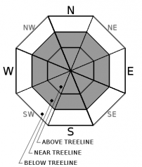
Bottom Line
Avalanche danger is moderate above treeline. Look for isolated wind slabs in leeward terrain and avoid overhanging cornices. Be prepared for frigid temperatures if climbing into the upper reaches of the mountain. Avalanche danger is low near and below treeline.


Avalanche Problem 1: Wind Slab
-
Character ?

-
Aspect/Elevation ?
-
Likelihood ?CertainVery LikelyLikelyPossible
 Unlikely
 -
Size ?HistoricVery LargeLargeSmall

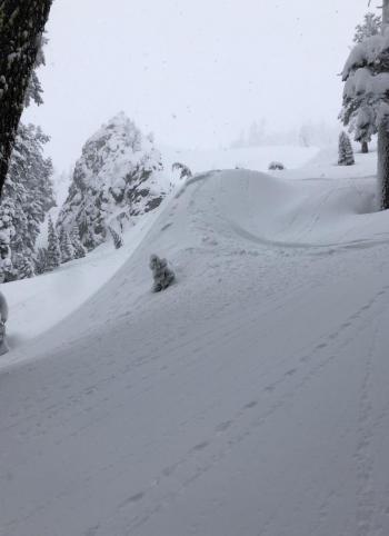
Wind slabs may still be encountered in isolated areas. Cornice formation, cracking, or blocking indicate the presense of this problem. Before entering leeward terrain greater than 35 degrees, evaluate the snowpack carefully. With plenty of light snow available for transport, moderate northerly winds may continue to build cornices and wind slabs today.
Forecast Discussion
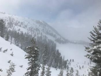
Overall, the snow pack has adjusted well to new snow over the last few days. Very few signs of instability have been observed. Cornices, though still growing, are resistant to any significant failures. Still, they are overhanging in places and will fail if you venture out too far. Stay clear.
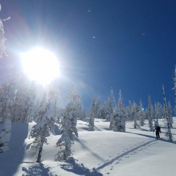
Climbers seeking enlightenment through suffering will find frigid temperatures suitable for their quest while making forays onto the upper regions of the Mount Shasta. Be prepared. Bring appropriate clothing and gear to protect you from the elements.
Recent Observations
In the last 24 hours, we have received a trace of new snow. Temperatures have ranged from 20 to 3 °F. Near treeline, westerly winds have been light.
A long tour up into Gray Rocks Lakes and around into Castle Lake for a snow survey exposed observers to a variety of aspects, elevations, and terrain features. No signficant signs of instabiltiy were encountered throughout. A very minor wind slab was triggered on a steep slope below a west facing ridgeline. Cornices were stubborn to trigger. Similar conditions were encountered on tours of Gray Butte.
Castle Lake Road is open and plowed.
Weather and Current Conditions
Weather Summary
The low pressure system that has been bringing cold wet weather from the north into the area is moving east out of the region. Some scattered snow showers may been seen today and tonight, but only trace amounts of snow are expected. Snow levels will remain below town and temperatures above treeline will be near 0 °F. Northerly winds will be moderate.
Unsettled weather will return by this weekend bringing a steady amount of cold weather and snow for several days.
If below normal temperatures and above normal precipitation is your bag, the climate prediction center is showing pleasing data for the next month.
24 Hour Weather Station Data @ 5:00 AM
| Weather Station | Temp (°F) | Wind (mi/hr) | Snow (in) | Comments | ||||||||
|---|---|---|---|---|---|---|---|---|---|---|---|---|
| Cur | Min | Max | Avg | Avg | Max Gust | Dir | Depth | New | Water Equivalent | Settlement | ||
| Mt. Shasta City (3540 ft) | 22 | 22 | 35 | 28 | 2 | N | ||||||
| Sand Flat (6750 ft) | 1 | 1 | 23 | 14 | 90.2 | 0 | .12 | 1 | ||||
| Ski Bowl (7600 ft) | 2.5 | 2.5 | 20.5 | 11.5 | 115 | 0 | 0.23 | 2 | ||||
| Gray Butte (8000 ft) | 3.5 | 3.5 | 20.5 | 11 | 10 | 37 | WNW | |||||
| Castle Lake (5870 ft) | 12 | 11.5 | 29 | 18.5 | 73 | 0 | 0 | |||||
| Mount Eddy (6509 ft) | 25 | 24.5 | 31 | 28 | 1 | 8 | S | 78 | 2 | 0 | ||
| Ash Creek Bowl (7250 ft) | station down | |||||||||||
| Ash Creek Ridge (7895 ft) | station down |
Two Day Mountain Weather Forecast
Produced in partnership with the Medford NWS
| For 7000 ft to 9000 ft | |||
|---|---|---|---|
|
Tuesday (4 a.m. to 10 p.m.) |
Tuesday Night (10 p.m. to 4 a.m.) |
Wednesday (4 a.m. to 10 p.m.) |
|
| Weather | Scattered snow showers. Partly sunny. Low wind chills. Chance of precipitation is 30%. | Scattered snow showers, mainly after 10 p.m. Mostly cloudy. Low wind chills. Chance of precipitation is 30%. | Mostly sunny. Low wind chills. |
| Temperature (°F) | 22 | 15 | 27 |
| Wind (mi/hr) | Northwest 5-10 | Northwest 5-10 | Northwest 5-10 |
| Precipitation SWE / Snowfall (in) | / 0 | / 0 | / 0 |
| For 9000 ft to 11000 ft | |||
| Tuesday | Tuesday Night | Wednesday | |
| Weather | Scattered snow showers. Partly sunny and cold. Sub-zero wind chills. Chance of precipitation is 30%. | Scattered snow showers, mainly after 10 p.m. Mostly cloudy. Sub-zero wind chills3. Chance of precipitation is 30%. | Mostly sunny. Sub-zero wind chills. |
| Temperature (°F) | 4 | 4 | 14 |
| Wind (mi/hr) | North 15-20 | Northwest 0 | Northwest 30-25 |
| Precipitation SWE / Snowfall (in) | / 0 | / 0 | / 0 |
Season Precipitation for Mount Shasta City
| Period | Measured (in) | Normal (in) | Percent of Normal (%) |
|---|---|---|---|
| From Oct 1, 2025 (the wet season) | 16.31 | 23.24 | 70 |
| Month to Date (since Jun 1, 2026) | 2.38 | 0.97 | 245 |
| Year to Date (since Jan 1, 2026) | 7.90 | 8.03 | 98 |

