

You are here
Avalanche Forecast for 2019-02-06 06:00
- EXPIRED ON February 7, 2019 @ 6:00 amPublished on February 6, 2019 @ 6:00 am
- Issued by Aaron Beverly - Mount Shasta Avalanche Center
Bottom Line
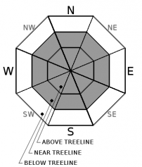
Avalanche danger is moderate above treeline. Look for isolated wind slabs in leeward terrain and avoid overhanging cornices. Be prepared for frigid temperatures if climbing into the upper reaches of the mountain. Avalanche danger is low near and below treeline.


Avalanche Problem 1: Wind Slab
-
Character ?

-
Aspect/Elevation ?
-
Likelihood ?CertainVery LikelyLikelyPossible
 Unlikely
 -
Size ?HistoricVery LargeLargeSmall

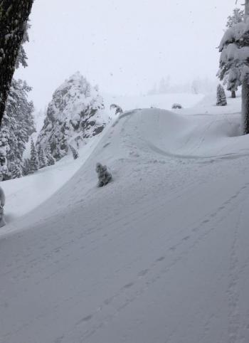
Moderate wind was transporting snow above treeline yesterday in a southeasterly direction, though cornices and wind slabs did not appear to be growing. However, it will be a good idea to continue to keep an out for this problem. Cornice formation, cracking, or blocking indicate the presence of wind slabs nearby. Before entering leeward terrain greater than 35 degrees, evaluate the snowpack carefully.
Forecast Discussion
Overall, the snow pack has adjusted well to new snow. Very few signs of instability have been observed. Cornices are stubborn to trigger, but they are overhanging in places and will fail if you venture out too far. Stay clear.
Be prepared for frigid temperatures and sub-zero wind chills if attempting to climb Mount Shasta.
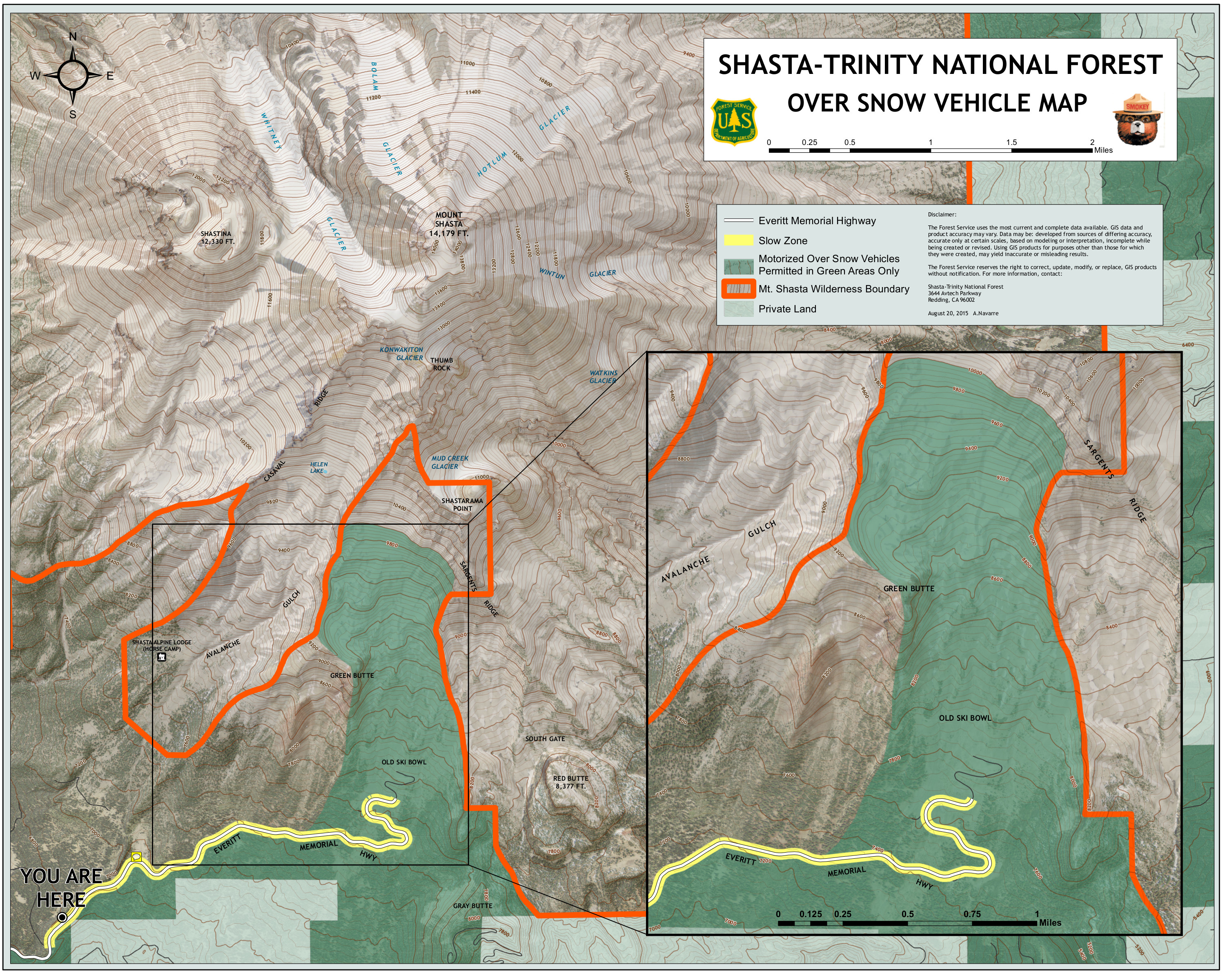
We've had some snowmobilers in the Sun Bowl area. Generally speaking, snow vehicles should stay on or below the road beyond Bunny Flat for 1.3 miles. Once hitting the first major switchback near Panther Meadow Campground, you are free to venture up to 10,000 feet into the Old Ski Bowl. Below is a map showing snow vehicle boundaries.
Recent Observations
In the last 24 hours, we have received no accumulation of snow. Temperatures have ranged from 18 to 3 degrees F. Near treeline, easterly and northerly winds have been mostly light. Last night northwest winds became strong maxing out at 36 mi/hr and gusting up to 55.
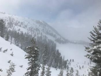
Conditions above treeline in the Old Ski Bowl @ 2:00 p.m., February 5th:
- Moderate northwest winds.
- Wind transporting snow.
- No signs of cornice or wind slab growth.
- Surface snow: sastrugis, soft 4F wind board.
- Snowpack: ≈ 60 cm of recent snow consisting of soft wind board atop mixed layers of wind broken and wind-packed grains. Old snow interface is a impenetrable ice layer that probably formed during the rain on snow event on February 1st.
- Column test results: ECTN ↓ 20 cm, ECTN ↓ 30 cm; failures occurring on density breaks in new snow.
- No recent signs of instability.
- Snowpack unreactive to snowmobile traffic.
- HS: 290 cm (114 in).
Weather and Current Conditions
Weather Summary
A high pressure ridge will keep conditions cold and dry today and tonight.
A weak front is expected to bring a smattering a snow Thursday and Friday. A low pressure system will significantly impact the area Saturday delivering over an inch of precipitable water. The good news is that snow levels are near guaranteed to stay at 2000 feet or below throughout - bad news if you don't like shovel snow.
24 Hour Weather Station Data @ 5:00 AM
| Weather Station | Temp (°F) | Wind (mi/hr) | Snow (in) | Comments | ||||||||
|---|---|---|---|---|---|---|---|---|---|---|---|---|
| Cur | Min | Max | Avg | Avg | Max Gust | Dir | Depth | New | Water Equivalent | Settlement | ||
| Mt. Shasta City (3540 ft) | 22 | 22 | 35 | 28 | 2 | N | ||||||
| Sand Flat (6750 ft) | 18 | 1 | 19 | 15 | 91 | 0 | 0 | 0 | ||||
| Ski Bowl (7600 ft) | 13 | 2.5 | 18 | 12 | 112.8 | 0 | 0.03 | 2 | ||||
| Gray Butte (8000 ft) | 11 | 3.5 | 17 | 11 | 12 | 55 | NW | |||||
| Castle Lake (5870 ft) | 17.5 | 11.5 | 21.5 | 17 | 71.5 | 0 | 1.5 | |||||
| Mount Eddy (6509 ft) | 16.5 | 10.5 | 18 | 15 | 2 | 13 | SSE | 82.3 | 0 | 0.5 | ||
| Ash Creek Bowl (7250 ft) | station down | |||||||||||
| Ash Creek Ridge (7895 ft) | station down |
Two Day Mountain Weather Forecast
Produced in partnership with the Medford NWS
| For 7000 ft to 9000 ft | |||
|---|---|---|---|
|
Wednesday (4 a.m. to 10 p.m.) |
Wednesday Night (10 p.m. to 4 a.m.) |
Thursday (4 a.m. to 10 p.m.) |
|
| Weather | A 20 percent chance of snow showers before 10 a.m. Mostly sunny. Low wind chills. | Partly cloudy. Low wind chills. | A 20 percent chance of snow showers after 10 a.m. Partly sunny. |
| Temperature (°F) | 27 | 9 | 28 |
| Wind (mi/hr) | Northwest 10-15 | North 5-10 | Southeast 0-5 |
| Precipitation SWE / Snowfall (in) | / 0 | / 0 | / 0 |
| For 9000 ft to 11000 ft | |||
| Wednesday | Wednesday Night | Thursday | |
| Weather | A 20 percent chance of snow showers before 10 a.m. Mostly sunny. Windy. Sub-zero wind chills. | Partly cloudy. Windy. Sub-zero wind chills. | A 20 percent chance of snow showers after 10 a.m. Partly sunny. Low wind chills. |
| Temperature (°F) | 15 | 15 | 16 |
| Wind (mi/hr) | North 35-45 | North 0 | West 5-10`\ |
| Precipitation SWE / Snowfall (in) | / 0 | / 0 | / 0 |
Season Precipitation for Mount Shasta City
| Period | Measured (in) | Normal (in) | Percent of Normal (%) |
|---|---|---|---|
| From Oct 1, 2025 (the wet season) | 16.31 | 23.48 | 69 |
| Month to Date (since Jun 1, 2026) | 2.38 | 1.21 | 197 |
| Year to Date (since Jan 1, 2026) | 7.90 | 8.27 | 96 |

